

 category 4 US, gradually approaching the Pilbara coast of WA")
 intensifying next 36h over the Gulf of Carpentaria")
 category 4 US, may intensify to Super Cyclone intensity within 24hours")

: expected to intensify very rapidly next 48hours over the Gulf of Carpentaria")
 category 4 US, may reach category 5 within 12 hours")
 intensifying rapidly next 48hours north-west of Western Australia")

: flaring convection, slow-moving system")
 intensifying rapidly next 48h to the north-west of Western Australia")
: close to moving back over sea, expected to intensify rapidly next 48h over Gulf of Carpentaria")

 intensifying rapidly to the north-west of Western Australia")

, flaring convection, cyclone still figthing vertical wind shear")

 has formed, expected to intensify rapidly next 48h north-west of Western Australia")

 is overland, rapid intensification over the Gulf of Carpentaria expected after 36hours")

 with flaring convection but still expected to fall below 35knots intensity in 36hours")

 : intensity could fall below 35knots in 36hours maybe sooner")


 making landfall less than 40km south of Lockhart as a strong category 2 US, rapid intensification expected over the Gulf")

 :extreme rapid intensification, landfall close to Lockhart as a Cat 3 US, rapid intensication expected over the Gulf in 48hours")

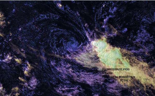
 has been weakening rapidly in the middle of the South Indian Ocean")

 intensifying rapidly over the Coral Sea, landfall in 18hours, likely intensifying rapidly once over the Gulf of Carpentaria")


 category 1 US is weakeing over the open seas of the South Indian Ocean")

 intensifying rapidly over the Coral Sea, landfall expected shortly after 24hours close to Lockhart/Queensland")

 is weakening over the open waters of the South Indian Ocean")


 intensifying rapidly over the Coral Sea with expected landfall over Cape York shortly before 36h")

Les News
WESTERN PACIFIC:TY 07W(MEKKHALA) approaching OKINAWA while weakening/08W(HIGOS) to merge with 07W in approx 60h/Invest 95W//24@1030 UTC
06/24/2026
- PATRICK HOAREAU
WESTERN PACIFIC:Typhoon 07W(MEKKHALA) Rapid Intensification likely next 24h forecast Peak Intensity at CAT 4 US in 48h/ Invest 94W//21@1000 UTC
06/21/2026
- PATRICK HOAREAU
WESTERN PACIFIC: TS 07W(MEKKHALA) forecast to reach Typhoon Intensity by 24h, forecast to peak at CAT 3 US in 72h//20@1000 UTC
06/20/2026
- PATRICK HOAREAU
WESTERN PACIFIC: Invest 92W/ SOUTH PACIFIC: Invest 96P/3 Week Tropical Cyclone Formation Probability//17@1030 UTC
06/17/2026
- PATRICK HOAREAU
WESTERN PACIFIC: Invest 92W/SOUTH PACIFIC: Subtropical Storm 96P/EASTERN PACIFIC: Invest 93E//15@0730 UTC
06/15/2026
- PATRICK HOAREAU
SOUTH INDIAN: Subtropical Storm 95S// 11/0900 UTC
06/11/2026
- PATRICK HOAREAU

Liens utiles
WESTERN PACIFIC:Typhoon 07W(MEKKHALA) Rapid Intensification likely next 24h forecast Peak Intensity at CAT 4 US in 48h/ Invest 94W//21@1000 UTC
WESTERN PACIFIC: TS 07W(MEKKHALA) forecast to reach Typhoon Intensity by 24h, forecast to peak at CAT 3 US in 72h//20@1000 UTC
WESTERN PACIFIC: Invest 92W/ SOUTH PACIFIC: Invest 96P/3 Week Tropical Cyclone Formation Probability//17@1030 UTC
WESTERN PACIFIC: Invest 92W/SOUTH PACIFIC: Subtropical Storm 96P/EASTERN PACIFIC: Invest 93E//15@0730 UTC
SOUTH INDIAN: Subtropical Storm 95S// 11/0900 UTC
S'identifier