CLICK ON THE IMAGERIES BELOW TO GET THEM ENLARGED

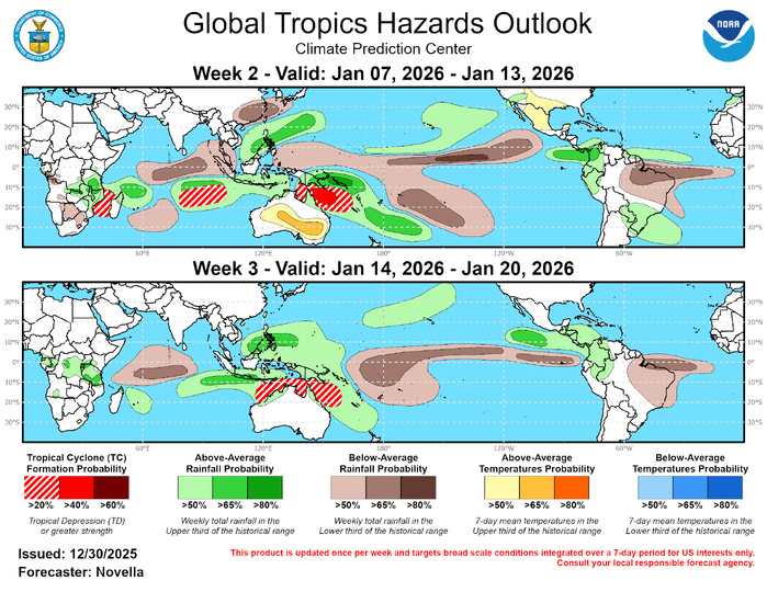
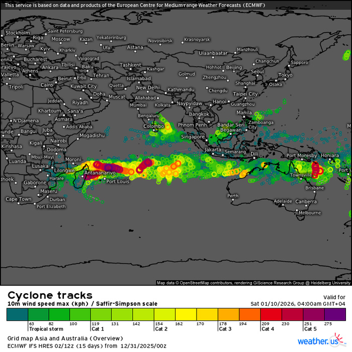
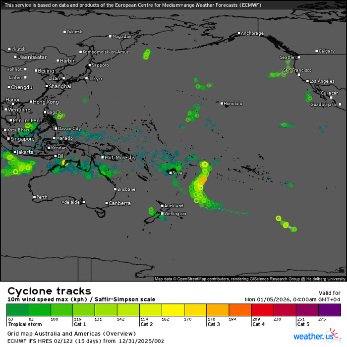
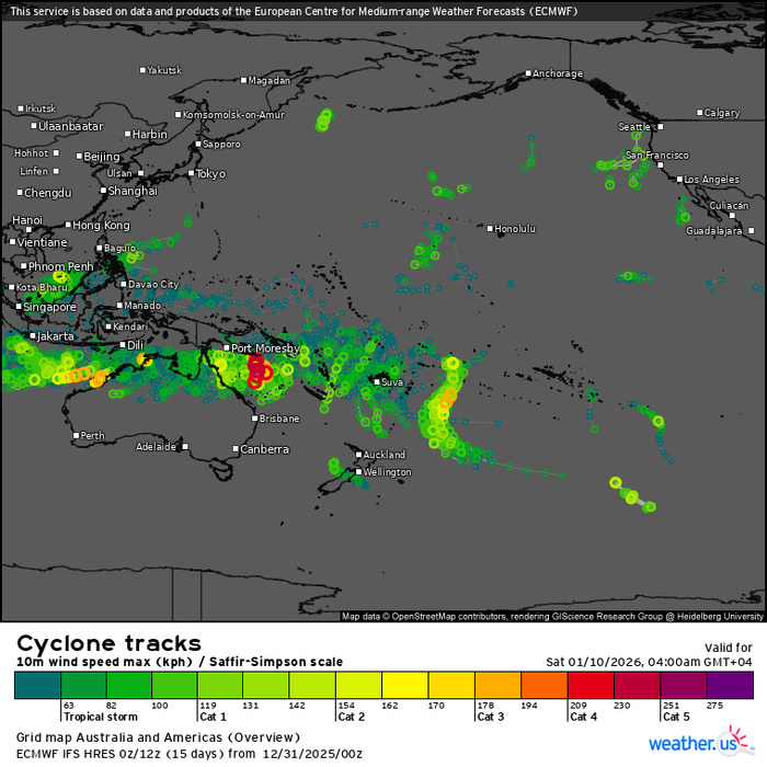
GTH Outlook Discussion Last Updated - 12/30/25 Valid - 01/07/26 - 01/20/26 The MJO remains quite weak and disorganized based on RMM observations and upper-level velocity potential anomaly fields through late December. Any upticks in RMM amplitude have been brief, as other modes of tropical variability appear to be predominant drivers in the tropics. Consistent with the ongoing La Nina, a region of strongly suppressed convection was observed recently near the Date Line, though other La Nina related anomalies have begun to shift across portions of the equatorial Pacific likely due to other interfering dynamics at play. Specifically, this includes a relaxed trade wind regime east of the Date Line tied to strong equatorial Rossby wave activity over the Pacific, as well as, below normal SST and subsurface temperatures becoming more confined to the eastern Pacific as an eastward expansion of warming ocean temperatures over the Central Pacific suggests ongoing oceanic downwelling Kelvin wave activity. Looking ahead, RMM forecasts have been consistent in favoring a continuation of the status quo, with little indication of any coherent MJO activity reemerging in the coming weeks. Several ensemble members from the dynamical models place their higher amplitude solutions that span multiple phases in RMM space, which is contributing to high uncertainty in the subseasonal outlook. However, if any reemergence of the MJO were to occur later in January, the western Pacific would appear to be the most likely part of the tropics based on upper-level velocity potential and lower level zonal wind anomaly forecasts. Should this occur, the lower level westerly phase of the MJO would reinforce the aforementioned warming waters over the Central Pacific and help further erode La Nina. Notwithstanding these potential outcomes, the updated outlook relies mostly on the La Nina background state, model guidance, and climatology. Since 12/24, one Tropical Cyclone (TC) formed in the tropics with one TC remaining active upon forming from the week prior. In the southeastern Indian Ocean, TC Hayley formed on 12/28 over the Timor Sea and intensified to a category 2 strength system where it made landfall over the Dampier Peninsula of northern Australia. The Joint Typhoon Warning Center (JTWC) expects Hayley to dissipate over land, and models show heavy rainfall amounts which may trigger localized flooding over the region during the next few days. After forming on 12/18 near 12S/110W to the south of Java, Indonesia, TC Grant has continued to track westward and steadily gain strength across the southern Indian Ocean. Currently positioned near 14S/78E in the south-central part of the basin as a Category 4 system, the JTWC expects Grant to continue tracking westward steered by a rebuilding subtropical ridge, and experience some fluctuations in intensity later this week. Beyond the official track period, model guidance shows Grant remaining as a closed tropical low as it approaches to the northeast of Madagascar. However the eventual track and strength of Grant remain quite uncertain at this lead. For further updates on this system, please refer to https://www.metoc.navy.mil/jtwc/jtwc.html. Environmental conditions are expected to remain favorable for additional TC development over the southern Indian Ocean and parts of the South Pacific during the next two weeks. There is good consistency in the ensembles and probabilistic genesis tools favoring formation in the south-central Indian Ocean in the wake of TC Grant, with an increasing potential for development over the Mozambique Channel. Although odds of formation look to be highest during the week-1 period, 20% chances are posted for week-2 over the Mozambique Channel and 20% chances from approximately 80E to 100E given the potential for delayed development in the tools. In the South Pacific, higher chances for TC development are posted (40%) based on good agreement in the ECMWF ensemble and AI based solutions over the Coral Sea. Surrounding this area, 20% chances extend from the Gulf of Carpentaria to near New Caledonia where ensembles maintain a broader area of mean low pressure. North of the equator, there is also some tool support for TC development over the Bay of Bengal and in the South China Sea. However no corresponding shapes are issued as outlook confidence is tempered by a quiet January climatology in these basins. For week-3, extended range probabilistic guidance points to additional development in the southern Indian Ocean and areas north of Australia by mid-January. While the return of coherent subseasonal activity remains uncertain, 20% chances are posted over portions of the southeastern Indian Ocean and the South Pacific where anomalous lower-level westerlies are favored to persist with more enhanced divergence aloft in the GEFS and ECMWF ensembles over this part of tropics.
Last Updated - 30/12/25 3 WEEK TROPICAL CYCLONE FORMATION PROBABILITY

The precipitation outlook for weeks 2 and 3 is based on background La Nina conditions, anticipated TC tracks, and a consolidated skill weighted blend of CFSv2, GEFS, and ECMWF ensemble guidance. For temperatures, above-normal but non hazardous temperatures are favored for much of the western and central CONUS. Above-normal temperatures with possible extreme heat conditions are also favored for portions of interior Australia where tools show increased chances for daytime temperatures exceeding 105 degrees F. For hazardous weather conditions in your area during the next two weeks, please refer to your local NWS office, the Medium Range Hazards Forecast from the Weather Prediction Center (WPC), and the CPC Week-2 Hazards Outlook. Forecasts issued over Africa are made in coordination with the International Desk at CPC.
