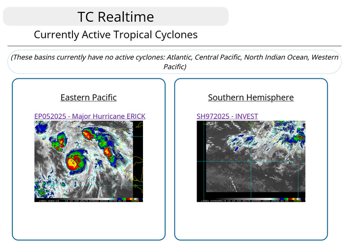
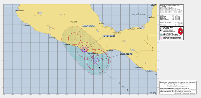
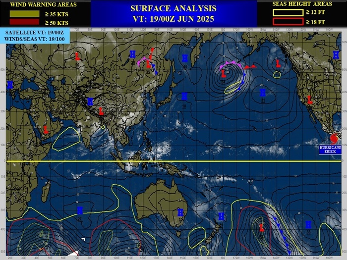
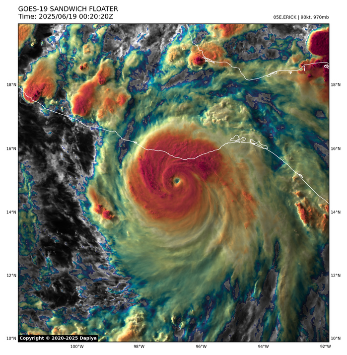
EASTERN NORTH PACIFIC: HURRICANE 05E(ERICK). 19/03UTC ESTIMATED LOCATION AND INTENSITY. INTENSITY IS 110 KNOTS/CAT 3 US.
0525061400 90N 844W 20
0525061406 90N 851W 20
0525061412 91N 858W 25
0525061418 92N 865W 25
0525061500 93N 872W 25
0525061506 94N 876W 25
0525061512 94N 879W 25
0525061518 94N 884W 25
0525061600 94N 891W 25
0525061606 97N 899W 25
0525061612 100N 906W 25
0525061618 106N 915W 30
0525061700 112N 924W 30
0525061706 117N 932W 35
0525061712 121N 937W 40
0525061718 125N 941W 45
0525061800 128N 946W 50
0525061806 131N 951W 55
0525061812 136N 957W 70
0525061818 142N 963W 90
0525061900 149N 967W 105
0525061903 152N 971W 110
WARNING 10 ISSUED AT 19/04UTC. NHC DISCUSSION ISSUED AT 19/03UTC
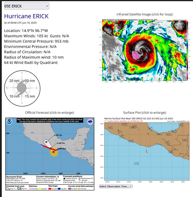
Hurricane Erick Discussion Number 10
NWS National Hurricane Center Miami FL EP052025
900 PM CST Wed Jun 18 2025
Erick's rapid intensification continued through 18/23Z. as an Air
Force Reserve Hurricane Hunter aircraft near that time reported
that the central pressure had fallen to 953 mb. However, since
that time, the satellite appearance of the hurricane went through
a period when it was a little degraded, suggesting that the
intensification rate may have slowed. This may be due to an
attempted eyewall replacement cycle, as the aircraft data suggested
concentric wind maxima during its pass through the center. The
intensity is a little uncertain, as the plane had to abort due to
computer problems before it could probe the northeastern eyewall.
Based on the central pressure, the observed wind structure, and the
various satellite intensity estimates, the initial intensity is set
to a possibly conservative 110 kt.
The initial motion estimate is northwestward at 320/8 kt. This
motion should bring the center to the Mexican coast in the state of
Oaxaca within the next 12 h, with a subsequent northwestward motion
bringing the system farther inland over southern Mexico on Thursday
and Thursday night. The forecast guidance is essentially the same
as for the previous advisory, and the new forecast track has a
slight nudge to the right based on the current location and motion.
Conditions continue to be favorable for strengthening, and it is
possible that Erick could get stronger before landfall if the
possible eyewall replacement completes. Regardless of additional
intensification, rapid weakening is expected after landfall, and
Erick is expected to dissipate over southern Mexico Thursday night
or Friday.
KEY MESSAGES:
1. Erick continues to intensify and is now a major hurricane. It
is expected to be a major hurricane when it reaches the coast of
Mexico in the western portion of the state of Oaxaca or the eastern
portion of the state of Guerrero within the hurricane warning area
early Thursday. Devastating wind damage is possible where the core
of the storm moves onshore. Weather conditions are already
deteriorating, and preparations to protect life and property should
be rushed to completion.
2. Erick will produce heavy rainfall across portions of Central
America and Southwest Mexico through this week. Life-threatening
flooding and mudslides are likely, especially in areas of steep
terrain.
3. A dangerous, life-threatening storm surge is expected to produce
coastal flooding near and to the east of where the center crosses
the coast, in areas of onshore winds. The surge will be accompanied
by large and destructive waves.
FORECAST POSITIONS AND MAX WINDS
INIT 19/0300Z 15.2N 97.1W 110 KT 125 MPH
12H 19/1200Z 16.2N 97.8W 85 KT 100 MPH...INLAND
24H 20/0000Z 17.8N 99.1W 30 KT 35 MPH...INLAND
36H 20/1200Z...DISSIPATED
$$
Forecaster Beven
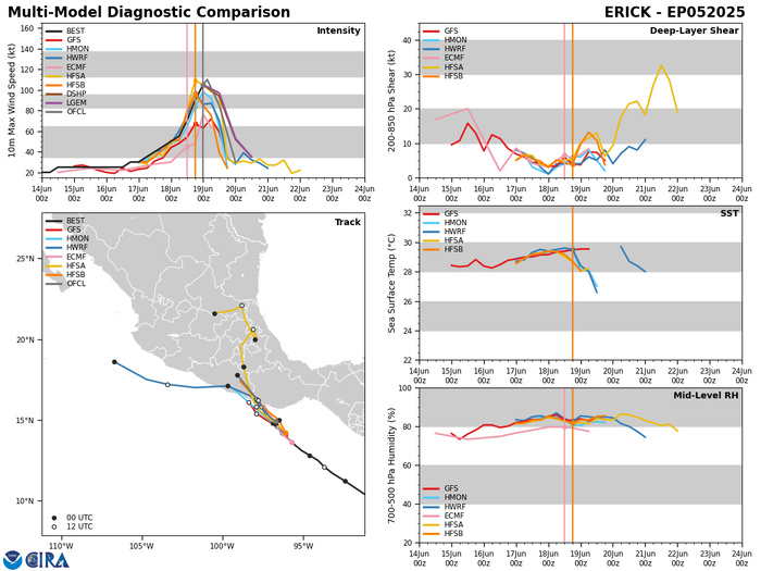
Model Diagnostic Plot
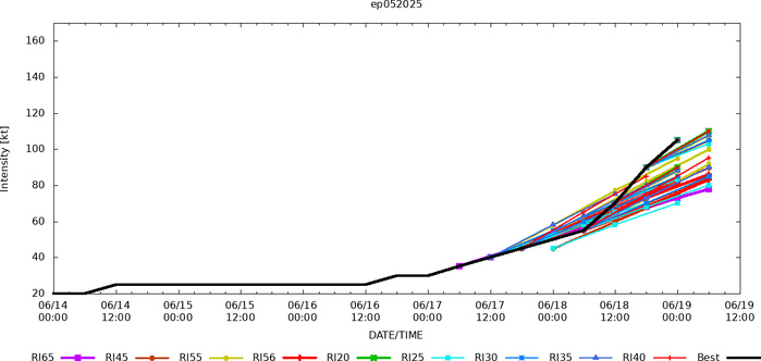
Rapid Intensification Guidance
19/00UTC SATELLITE ANALYSIS
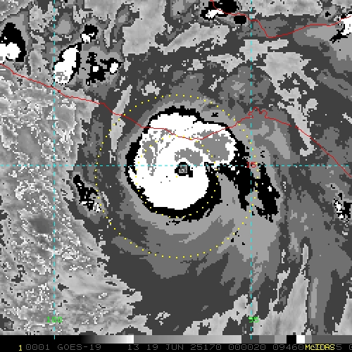
TXPZ27 KNES 190022
TCSENP
A. 05E (ERICK)
B. 19/0000Z
C. 14.9N
D. 96.7W
E. ONE/GOES-E
F. T6.0/6.0
G. IR/EIR/VIS/AMSR2
H. REMARKS...OW EYE SURROUNDED BY W AND EMBEDDED IN B RESULTS IN AN E#
OF 5.5 WITH AN E# ADJUSTMENT OF 0.5 FOR A DT OF 6.0. THE MET EQUALS 5.5
AND THE PT EQUALS 6.0. THE FT IS BASED ON THE DT.
I. ADDL POSITIONS
18/1955Z 14.5N 96.3W AMSR2
...LINER
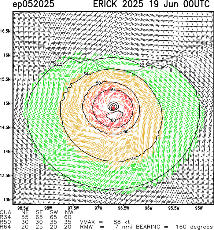
Aircraft-based Tropical Cyclone Surface Wind Analysis
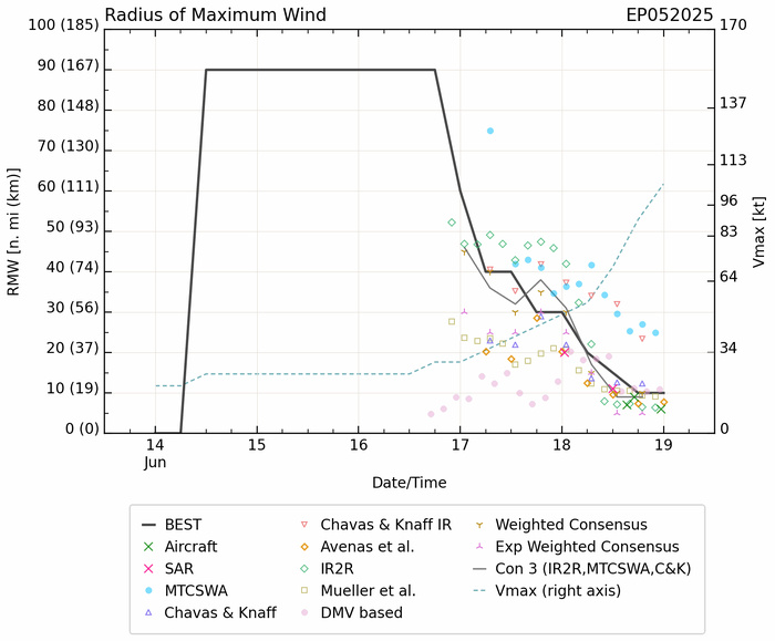
Radius of Maximum Wind (RMW)
Last Updated - 06/17/25 3 WEEK TROPICAL CYCLONE FORMATION PROBABILITY
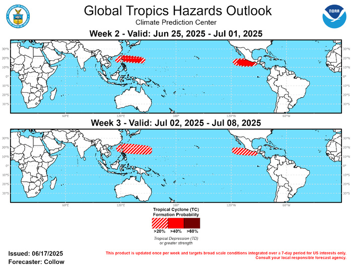
GTH Outlook Discussion Last Updated - 06/17/25 Valid - 06/25/25 - 07/08/25 During the past week, the RMM-based MJO index rapidly weakened back into the unit circle following a more amplified signal across the Western Pacific in early June. However, despite the weakening, some coherency remained in its propagation across the Western Hemisphere, and the phase speed has been suggestive of a Convectively Coupled Kelvin Wave (CCKW). Following constructive interference with a westward propagating Equatorial Rossby Wave (ERW) across the Americas, the CCKW weakened as it reached Africa and Eurasia due to destructive interference with the persistent suppressed convective envelope over that region. By week-2, a similar pattern is forecast to take shape as dynamical models indicate increased upper-level divergence developing over the Western Pacific. RMM-based forecasts from the ECMWF and GEFS depict a bimodal distribution of ensemble members, with a clustering of some members within the eastern Indian Ocean and Maritime Continent, and others depicting a stronger signal quickly emerging across the Western Hemisphere indicative of CCKW activity moving across the Pacific. The interaction between the CCKW and ERW led to increased upper-level divergence aloft across the Americas in the past week. While increased wind shear limited tropical cyclone development across the Atlantic Basin, the favorable upper-level pattern resulted in a continuation of the quick start to the Eastern North Pacific Hurricane Season with 2 additional TC formations during the past week. Tropical Storms Dalila (6/13) and Erick (6/17) both formed to the south of Mexico. While Dalila was short-lived and remained offshore, Erick is forecast to impact the southern Mexico coast at hurricane intensity later this week. Additional CCKW activity during week-2 is likely to continue the fast start to the season, and individual ensemble members from the GEFS and ECMWF depict surface lows spinning up to the south of Mexico and Central America during this timeframe. Therefore, 40-60 percent chances of TC development are posted across the Eastern Pacific during week-2, and 20-40 percent chances continuing into week-3. The GEFS also depicts an enhanced signal for TC activity across the western Caribbean and Gulf of America, but has overdone the potential thus far, precluding any areas for potential TC development from being designated. Contrary to the Eastern Pacific, the Western North Pacific has seen an extremely slow start to its TC season, although there are some signs activity is beginning to increase. TC Wutip developed across the South China Sea and tracked into the Gulf of Tonkin making 2 landfalls in southeastern China, the second at minimal typhoon intensity. Enhanced convection is forecast to develop across the Western North Pacific by week-2, and combined with the increasing climatology for the basin, this supports a 40-60 percent chance of TC formation from the Philippines to about 140 deg E, with a 20-40 percent chance over the South China Sea. The GEFS and ECMWF indicate a meandering convective envelope by week-3, with a low frequency enhanced convective envelope possibly persisting across the Western Pacific into early July. This justifies a 20-40 percent chance of TC development during week-3, although there is larger uncertainty regarding higher frequency modes of variability which may further enhance or suppress TC development.
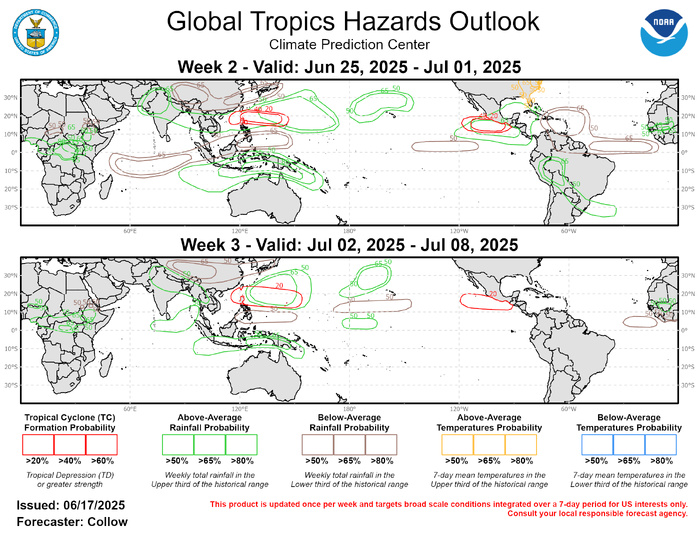
Absent clear subseasonal to seasonal forcing modes, the forecasts for above- and below-normal rainfall are based heavily on a consensus of operational dynamical model guidance. Enhanced convection across the Maritime Continent into the Western Pacific during weeks 2 and 3 increases confidence for above-normal rainfall from India eastward across southeastern Asia and into the Western Pacific. Above-normal rainfall is also predicted over the Southern Hemisphere, over Indonesia and Papua New Guinea. In contrast, below-normal rainfall is forecast across the Indian Ocean (week-2), extending into the southwestern Pacific (south of 10 deg N). Below-normal rainfall is also forecast across Interior China extending east to Japan. Above-normal rainfall is predicted across the Eastern Pacific and over parts of central South America during week-2, with below-normal rainfall indicated across the Equatorial Atlantic and eastern Caribbean. By week-3, there is more uncertainty in the overall convective pattern across the Western Hemisphere further reducing forecast confidence. A heat wave is predicted across the eastern U.S. beginning this weekend into next week supporting elevated probabilities for above-normal temperatures during week-2.
