

: flaring convection, slow-moving system")
 intensifying rapidly next 48h to the north-west of Western Australia")
: close to moving back over sea, expected to intensify rapidly next 48h over Gulf of Carpentaria")

 intensifying rapidly to the north-west of Western Australia")

, flaring convection, cyclone still figthing vertical wind shear")

 has formed, expected to intensify rapidly next 48h north-west of Western Australia")

 is overland, rapid intensification over the Gulf of Carpentaria expected after 36hours")

 with flaring convection but still expected to fall below 35knots intensity in 36hours")

 : intensity could fall below 35knots in 36hours maybe sooner")


 making landfall less than 40km south of Lockhart as a strong category 2 US, rapid intensification expected over the Gulf")

 :extreme rapid intensification, landfall close to Lockhart as a Cat 3 US, rapid intensication expected over the Gulf in 48hours")

 has been weakening rapidly in the middle of the South Indian Ocean")

 intensifying rapidly over the Coral Sea, landfall in 18hours, likely intensifying rapidly once over the Gulf of Carpentaria")


 category 1 US is weakeing over the open seas of the South Indian Ocean")

 intensifying rapidly over the Coral Sea, landfall expected shortly after 24hours close to Lockhart/Queensland")

 is weakening over the open waters of the South Indian Ocean")


 intensifying rapidly over the Coral Sea with expected landfall over Cape York shortly before 36h")


 category 2 US is now weakening over the open seas of the South Indian Ocean")

 has formed, intensifying rapidly over the Coral Sea with landfall over Cape York expected shortly after 36hours")


 is now an intense cyclone, category 3 US right in the middle of the South Indian Ocean")

 category 2 US intensifying over the open waters of the South Indian Ocean")


Les News
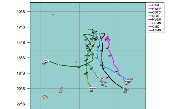
TC 24S(IALY) intensifying a bit//INVEST 93W//INVEST 93S// ECMWF 10 Day Storm Tracks//1706utc
05/17/2024
- PATRICK HOAREAU
INVEST 93W// INVEST 92S// 10 Day ECMWF Storm Tracks// 3 Week TC Formation Probability// 1503utc
05/15/2024
- PATRICK HOAREAU
Western North Pacific 3 Week TC Formation Probability// 0903utc
05/09/2024
- PATRICK HOAREAU
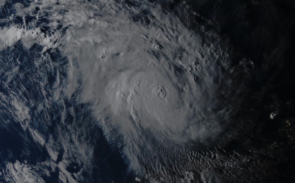
TC 23S(HIDAYA) peaked at 80 knots/CAT 1 US A NEW RECORD AS THE MOST INTENSE TC IN THIS REGION//0315utc
05/03/2024
- PATRICK HOAREAU
INVEST 90S Tropical Cyclone Formation Alert//ECMWF 10 Day Storm Tracks//3 Week TC Formation Probability//0103utc
05/01/2024
- PATRICK HOAREAU
ECMWF 10 Day Storm Tracks// 3Week TC Formation Probability// 2403utc
04/24/2024
- PATRICK HOAREAU

Liens utiles
INVEST 93W// INVEST 92S// 10 Day ECMWF Storm Tracks// 3 Week TC Formation Probability// 1503utc
Western North Pacific 3 Week TC Formation Probability// 0903utc
TC 23S(HIDAYA) peaked at 80 knots/CAT 1 US A NEW RECORD AS THE MOST INTENSE TC IN THIS REGION//0315utc
INVEST 90S Tropical Cyclone Formation Alert//ECMWF 10 Day Storm Tracks//3 Week TC Formation Probability//0103utc
ECMWF 10 Day Storm Tracks// 3Week TC Formation Probability// 2403utc
S'identifier