
:now Typhoon CAT 4 peaking within 12/24h//North Indian:TC 03B(GULAB) slowly intensifying while approaching India,25/15utc")
: intensifying up to Super Typhoon level in 72h//North Indian:TC 03B peaking within 24h up to landfall//Atlantic: 18L(SAM) getting stronger,25/03utc updates")
:forecast to reach STY intensity by 96hours//North Indian:TC 03B intensifying over the BOB//Atlantic:18L(SAM)intensifying Hurricane,24/09utc")
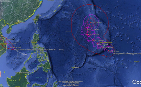
:rapid intensification next 48h, 21W(DIANMU):final warning//Atlantic:18L(SAM):rapid intensification next 48h,24/03utc")
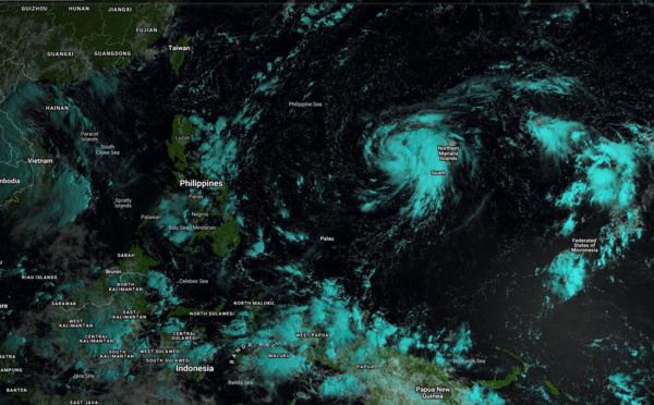
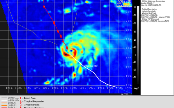
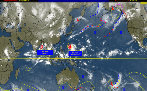
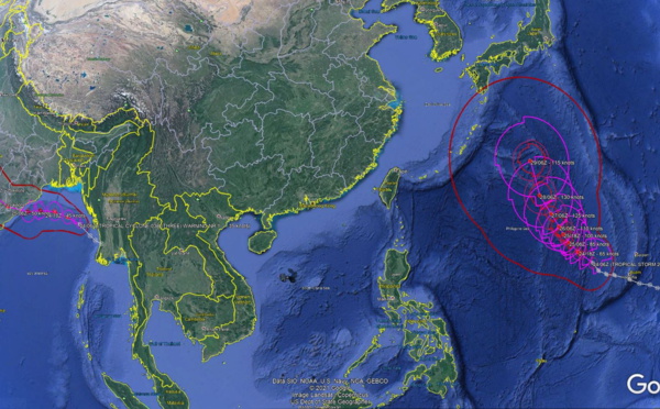
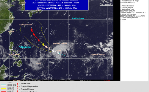
 landfall South of Dan Nang/TS 20W forecast to peak at Typhoon/CAT 4 by 96h//Atlantic: TD 18L intensifying, 23/09utc")


 Final Warning on the 2nd most intense cyclone of 2021//Atlantic: 15L(ODETTE) intensifying, 18/09utc")
 monitored for the past 12 days and still there//Atlantic: Tropical Cyclone Formation Alert issued again for 96L,17/09utc")
 intensity is forecast to peak near Typhoon level//Atlantic: 2 Tropical Cyclone Formation Alerts,16/09utc")
 still there and likely to re-intensify a bit//Atlantic: Tropical Cyclone Formation Alert, 15/09utc updates")

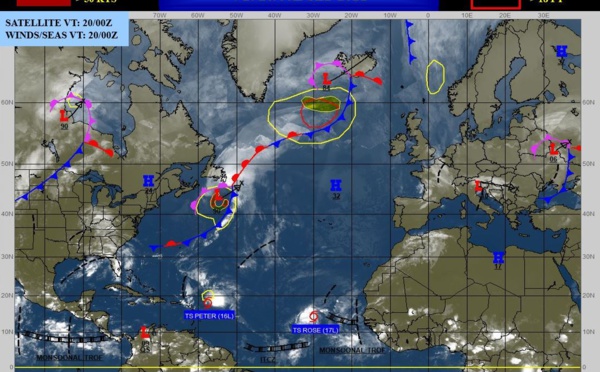
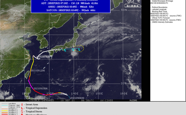
 slow-moving next 24hours//Atlantic: TS 14L(NICHOLAS) made landfall at Hurricane/CAT 1 now over-land,14/09utc")
 slowing down East of Shanghai as a CAT 1// Atlantic: TS 14L(NICHOLAS) deepening off Brownsville, 13/09utc updates")
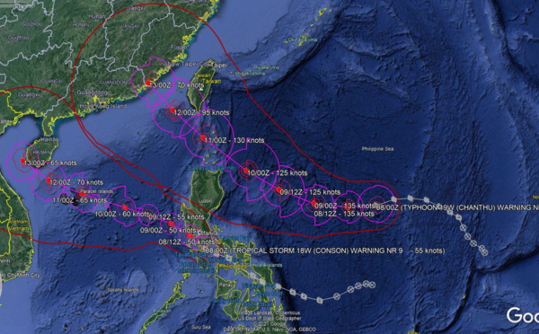
 CAT 2 weakening gradually,18W(CONSON): final warning// Invest 95B: intensity near 35knots, 12/21utc updates")
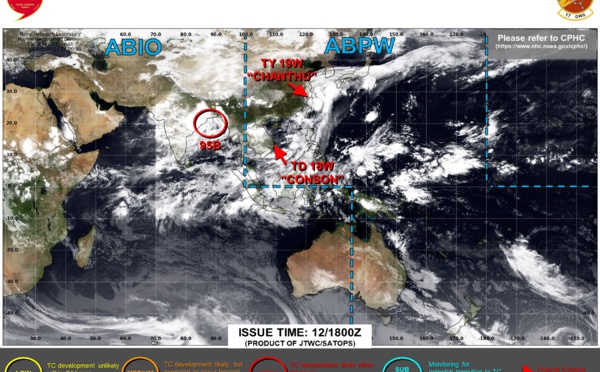
 resilient as a strong CAT 3//North Indian: Tropical Cyclone Formation Alert for Invest 95B, 12/09utc")
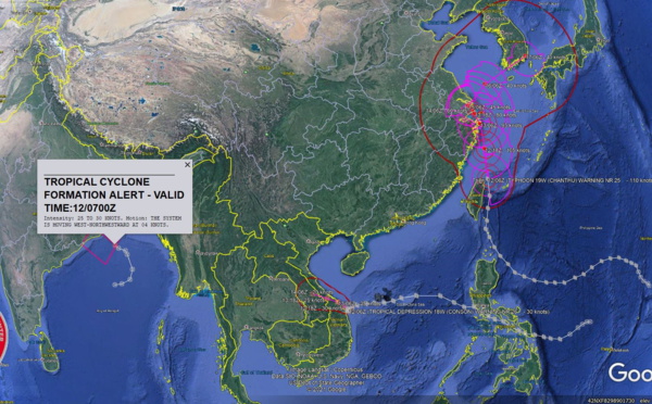
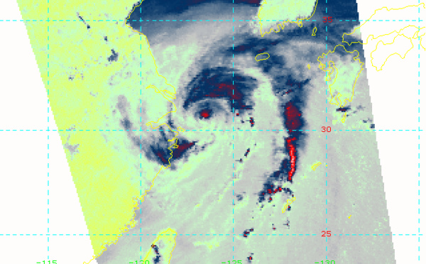
 displaying eye-wall cycles,TD 18W(CONSON) nearing Dan Nang//Eastern Pacific & Atlantic: TCFA's, 12/03utc updates")
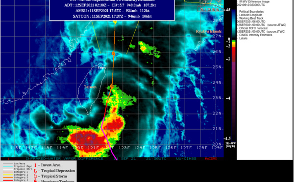
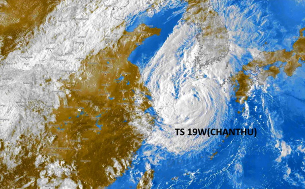
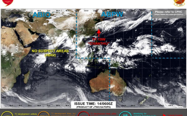
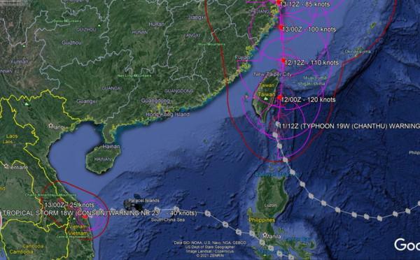
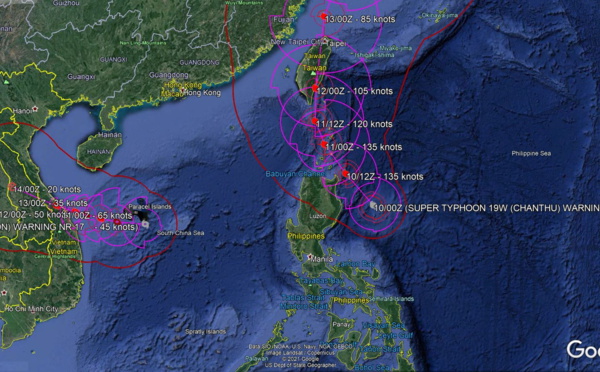
: landfall South of Dan Nang, 19W(CHANTHU) skirting Taiwan as a CAT 4 Typhoon, 11/15utc updates")
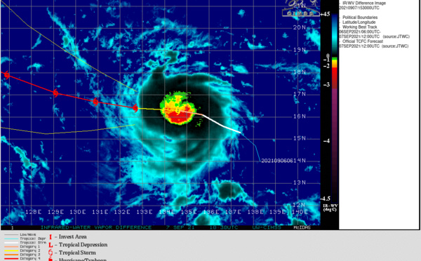
 peaked as a CAT 5(155knots) with gusts well over 300km/h, 11/03utc updates")
 is intensifying once again 215km SE of Aparri, 18W(CONSON) update, E.Pacific & Atlantic updates10/03utc")
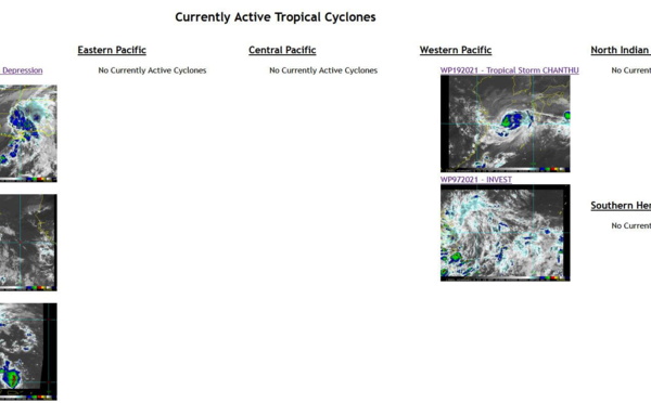
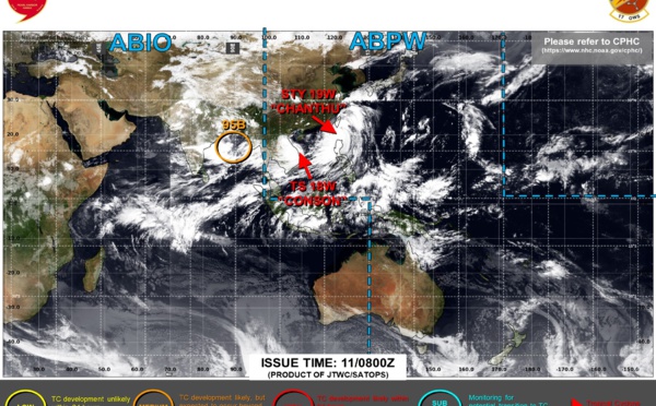
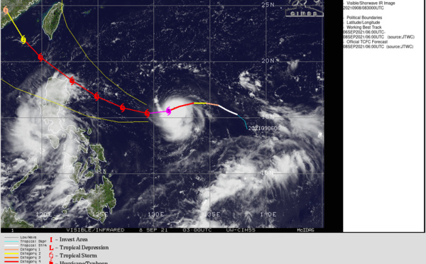
, TY 19W(CHANTHU) and Invest 96W: congested cyclonic traffic, 09/15 updates")
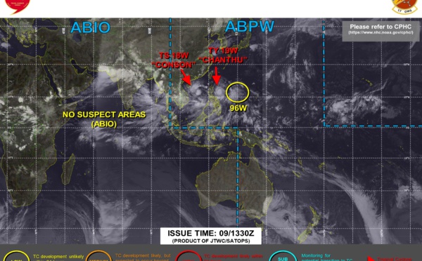
 gaining strength over South China Sea/Super Typhoon 19W(CHANTHU) back at CAT 5 over the Philippine Sea,EPacific & Atlantic updates,09/03utc")
 reaches CAT 5, 2nd in 2021 after 02W(SURIGAE) in April, 08/09utc update")
 tracking over Southern Luzon,19W(CHANTHU) forecast to reach Super Typhoon intensity within 24hours,15E & 12L(LARRY) updates,08/03utc")
 has been intensifying very rapidly and is now a CAT 4, 07/18utc update")
 set to intensify once over the South China Sea, 19W(CHANTHU) forecast to reach CAT 4 by 48h//Eastern Pacific & Atlantic updates,07/09utc")
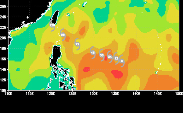
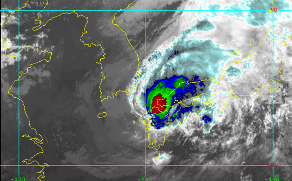
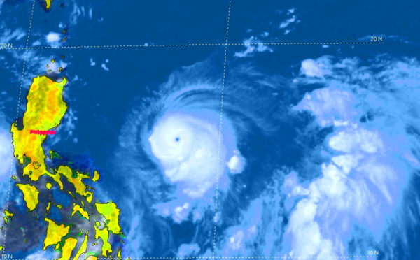
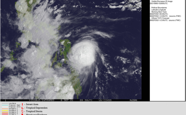
 is making landfall over Samar and then crossing the Philippines next 2/3 days, 06/15utc update")
Les News
WESTERN PACIFIC:TY 07W(MEKKHALA) approaching OKINAWA while weakening/08W(HIGOS) to merge with 07W in approx 60h/Invest 95W//24@1030 UTC
06/24/2026
- PATRICK HOAREAU
WESTERN PACIFIC:Typhoon 07W(MEKKHALA) Rapid Intensification likely next 24h forecast Peak Intensity at CAT 4 US in 48h/ Invest 94W//21@1000 UTC
06/21/2026
- PATRICK HOAREAU
WESTERN PACIFIC: TS 07W(MEKKHALA) forecast to reach Typhoon Intensity by 24h, forecast to peak at CAT 3 US in 72h//20@1000 UTC
06/20/2026
- PATRICK HOAREAU
WESTERN PACIFIC: Invest 92W/ SOUTH PACIFIC: Invest 96P/3 Week Tropical Cyclone Formation Probability//17@1030 UTC
06/17/2026
- PATRICK HOAREAU
WESTERN PACIFIC: Invest 92W/SOUTH PACIFIC: Subtropical Storm 96P/EASTERN PACIFIC: Invest 93E//15@0730 UTC
06/15/2026
- PATRICK HOAREAU
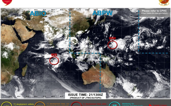
SOUTH INDIAN: Subtropical Storm 95S// 11/0900 UTC
06/11/2026
- PATRICK HOAREAU

Liens utiles
WESTERN PACIFIC:Typhoon 07W(MEKKHALA) Rapid Intensification likely next 24h forecast Peak Intensity at CAT 4 US in 48h/ Invest 94W//21@1000 UTC
WESTERN PACIFIC: TS 07W(MEKKHALA) forecast to reach Typhoon Intensity by 24h, forecast to peak at CAT 3 US in 72h//20@1000 UTC
WESTERN PACIFIC: Invest 92W/ SOUTH PACIFIC: Invest 96P/3 Week Tropical Cyclone Formation Probability//17@1030 UTC
WESTERN PACIFIC: Invest 92W/SOUTH PACIFIC: Subtropical Storm 96P/EASTERN PACIFIC: Invest 93E//15@0730 UTC
SOUTH INDIAN: Subtropical Storm 95S// 11/0900 UTC
S'identifier