

CLICK ON THE IMAGERIES BELOW TO GET THEM ENLARGED

JTWC PH
JTWC FACEBOOK
Joint Typhoon Warning Center
National Hurricane Center
11/03/2026
10/27/2026
10/20/2026
10/13/2026
10/06/2026
09/29/2026
09/22/2026
GTH Outlook Discussion
Last Updated - 11/10/26
Valid - 11/18/26 - 12/01/26
RMM observations show an Indian Ocean MJO signal that has grown to a high amplitude while resuming some eastward propagation during the past day or so. Based on zonal wind observations, the growing amplitude in RMM space appears to be tied to strengthening lower-level trades along the equator between 70E and 100E, resulting in decreasing RMM2 values, which is also reinforced by anomalous westerlies aloft over this part of the tropics. While some of this behavior can be explained, in part, by a positive Indian Ocean Dipole (+IOD) circulation, the SST dipole gradient is not particularly robust and several tools have been more supportive of a subseasonal component, including objective wave filtering over this part of the tropics.
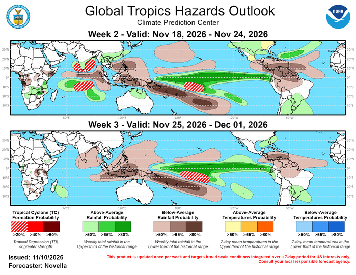
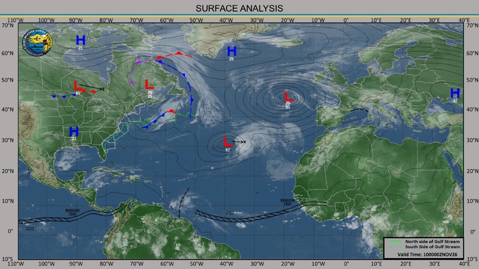
In light of the increasing MJO signal, a key focus of the outlook concerns how models bring in the ensuing lower-level westerly phase of the MJO over the Indian Ocean (that would project more strongly onto RMM phases 3 and 4), as this presents a period of destructive interference with not only with the +IOD, but also with the very strong El Nino background state that has dominated the global tropics.Guidance favors some weakening of the lower-level easterlies over the Indian Ocean, but to wildly varying extents among all the multi-model guidance suite contributing to outlook uncertainty. Interestingly, the ECMWF is the outlier this week and remains the least progressive with the MJO. An uptick in anomalous westerlies is favored over the equatorial Indian Ocean, but this development is short-lived and not as robust compared to other models. However, some resurgence of anomalous westerlies and enhanced divergence aloft is generally favored among all models over the equatorial Pacific in the longer leads, which could be pointing to an eastward propagating MJO resurfacing on the other side of the low frequency suppressed convective envelope in the equatorial Pacific. There is some support in the objective wave filtering for this realization, though this would be a fairly fast moving scenario more in-line with a convectively coupled Kelvin wave, and less of a canonical MJO. Taken all together, El Nino still remains favored to be the dominant tropical driver in the outlook, with the MJO and other modes of variability acting to modulate the low frequency convective responses. Tropical cyclogenesis is favored over the Indian Ocean and in the South Pacific tied to the MJO and El Nino forcing, respectively. Lowered chances for development are forecast over the eastern Pacific and Atlantic, consistent with climatology as the hurricane seasons conclude at the end of November for these basins.
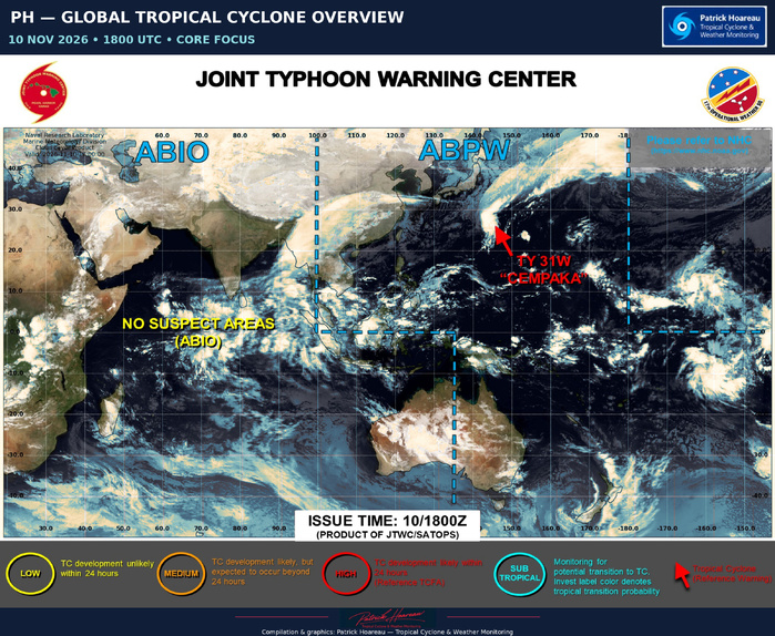
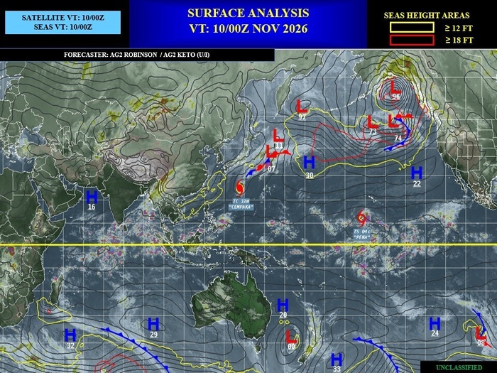
Three Tropical Cyclones (TCs) developed during the past week with two currently remaining active. A short-lived TC (03S) formed on 11/7 near 13S/52E, and later dissipated due to high shearing the next day to the north of Madagascar. In the western Pacific, TC Cempaka formed on 11/6 near 18N/150E and has tracked northwestward into the Philippine Sea and peaked at category 2 strength earlier this week. The Joint Typhoon Warning Center (JTWC) expects Cempaka to accelerate eastward and interact with a frontal boundary extending southward from mid-latitudes. By later this week, there is high uncertainty as to whether Cempaka fully dissipates due to high shearing, or if it decouples from the frontal boundary. For further updates on Cempaka, please refer to the JTWC at: https://www.metoc.navy.mil/jtwc/jtwc.html. In the central Pacific, TC Pena formed on 11/6 near 11N/150W and is the first TC to form during November in the basin since 1982. The National Hurricane Center (NHC) forecasts Pena to maintain Tropical Storm intensity while tracking westward, but eventually weaken to a Tropical Depression, with the possibility of degenerating further or open into a trough as it crosses the Date Line later this week.
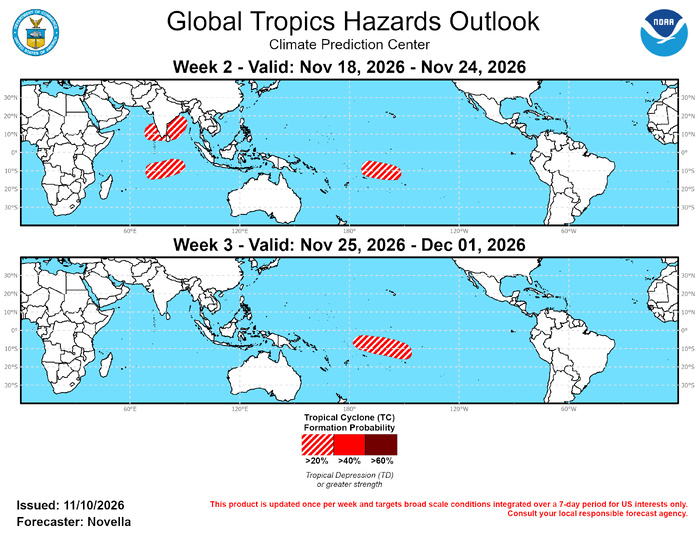
Following these two systems, model guidance has been fairly muted with additional TC genesis signals across the Pacific north of the equator and throughout the Atlantic basin during the next couple of weeks. With the El Nino related low-level anomalous westerlies expected to remain entrenched across the equatorial Pacific, additional formation is possible in the Central Pacific, though tools have been consistent in favoring the greatest development chances in the South Pacific from the Date Line to approximately 160W. Both ensemble and deterministic guidance points to formation most likely occurring late in week-1, however 20% chances are indicated in the week-2 outlook should formation be delayed later next week. With the large-scale environment expected to remain favorable for additional TC development, 20% chances are posted across a similar region in the South Pacific for week-3, which is also supported in the extended range TC tools. Given the proximity to American Samoa and surrounding islands, any westward tracking TCs that develop would bring increased chances for heavy precipitation, high winds and other adverse impacts.
Despite the large model spread in the strength and coverage of enhanced lower-level westerlies developing in the equatorial Indian Ocean tied to the MJO, tools have also been consistent in featuring a twin cyclone potential on both sides of the equator. Both the ECMWF and Google Deepmind guidance have become increasingly supportive of development in the Bay of Bengal, however, the highest chances for development are favored during the middle to later portions of week-1. Therefore, 20% chances are posted to capture any delay in formation across the western Bay of Bengal with coverage extending westward into the Arabian Sea where tools have shown some support for development (or possible reformation). South of the equator, TC genesis signals are comparably lower, though formation timing is closer to the start of week-2 to support 20% chances being posted from approximately 70E to 90E. For week-3, no TC genesis areas are highlighted in the Indian Ocean due to the lack of support in the extended range guidance, and uncertainties associated with the MJO.
JTWC FACEBOOK
Joint Typhoon Warning Center
National Hurricane Center
11/03/2026
10/27/2026
10/20/2026
10/13/2026
10/06/2026
09/29/2026
09/22/2026
GTH Outlook Discussion
Last Updated - 11/10/26
Valid - 11/18/26 - 12/01/26
RMM observations show an Indian Ocean MJO signal that has grown to a high amplitude while resuming some eastward propagation during the past day or so. Based on zonal wind observations, the growing amplitude in RMM space appears to be tied to strengthening lower-level trades along the equator between 70E and 100E, resulting in decreasing RMM2 values, which is also reinforced by anomalous westerlies aloft over this part of the tropics. While some of this behavior can be explained, in part, by a positive Indian Ocean Dipole (+IOD) circulation, the SST dipole gradient is not particularly robust and several tools have been more supportive of a subseasonal component, including objective wave filtering over this part of the tropics.
In light of the increasing MJO signal, a key focus of the outlook concerns how models bring in the ensuing lower-level westerly phase of the MJO over the Indian Ocean (that would project more strongly onto RMM phases 3 and 4), as this presents a period of destructive interference with not only with the +IOD, but also with the very strong El Nino background state that has dominated the global tropics.Guidance favors some weakening of the lower-level easterlies over the Indian Ocean, but to wildly varying extents among all the multi-model guidance suite contributing to outlook uncertainty. Interestingly, the ECMWF is the outlier this week and remains the least progressive with the MJO. An uptick in anomalous westerlies is favored over the equatorial Indian Ocean, but this development is short-lived and not as robust compared to other models. However, some resurgence of anomalous westerlies and enhanced divergence aloft is generally favored among all models over the equatorial Pacific in the longer leads, which could be pointing to an eastward propagating MJO resurfacing on the other side of the low frequency suppressed convective envelope in the equatorial Pacific. There is some support in the objective wave filtering for this realization, though this would be a fairly fast moving scenario more in-line with a convectively coupled Kelvin wave, and less of a canonical MJO. Taken all together, El Nino still remains favored to be the dominant tropical driver in the outlook, with the MJO and other modes of variability acting to modulate the low frequency convective responses. Tropical cyclogenesis is favored over the Indian Ocean and in the South Pacific tied to the MJO and El Nino forcing, respectively. Lowered chances for development are forecast over the eastern Pacific and Atlantic, consistent with climatology as the hurricane seasons conclude at the end of November for these basins.
Three Tropical Cyclones (TCs) developed during the past week with two currently remaining active. A short-lived TC (03S) formed on 11/7 near 13S/52E, and later dissipated due to high shearing the next day to the north of Madagascar. In the western Pacific, TC Cempaka formed on 11/6 near 18N/150E and has tracked northwestward into the Philippine Sea and peaked at category 2 strength earlier this week. The Joint Typhoon Warning Center (JTWC) expects Cempaka to accelerate eastward and interact with a frontal boundary extending southward from mid-latitudes. By later this week, there is high uncertainty as to whether Cempaka fully dissipates due to high shearing, or if it decouples from the frontal boundary. For further updates on Cempaka, please refer to the JTWC at: https://www.metoc.navy.mil/jtwc/jtwc.html. In the central Pacific, TC Pena formed on 11/6 near 11N/150W and is the first TC to form during November in the basin since 1982. The National Hurricane Center (NHC) forecasts Pena to maintain Tropical Storm intensity while tracking westward, but eventually weaken to a Tropical Depression, with the possibility of degenerating further or open into a trough as it crosses the Date Line later this week.
Following these two systems, model guidance has been fairly muted with additional TC genesis signals across the Pacific north of the equator and throughout the Atlantic basin during the next couple of weeks. With the El Nino related low-level anomalous westerlies expected to remain entrenched across the equatorial Pacific, additional formation is possible in the Central Pacific, though tools have been consistent in favoring the greatest development chances in the South Pacific from the Date Line to approximately 160W. Both ensemble and deterministic guidance points to formation most likely occurring late in week-1, however 20% chances are indicated in the week-2 outlook should formation be delayed later next week. With the large-scale environment expected to remain favorable for additional TC development, 20% chances are posted across a similar region in the South Pacific for week-3, which is also supported in the extended range TC tools. Given the proximity to American Samoa and surrounding islands, any westward tracking TCs that develop would bring increased chances for heavy precipitation, high winds and other adverse impacts.
Despite the large model spread in the strength and coverage of enhanced lower-level westerlies developing in the equatorial Indian Ocean tied to the MJO, tools have also been consistent in featuring a twin cyclone potential on both sides of the equator. Both the ECMWF and Google Deepmind guidance have become increasingly supportive of development in the Bay of Bengal, however, the highest chances for development are favored during the middle to later portions of week-1. Therefore, 20% chances are posted to capture any delay in formation across the western Bay of Bengal with coverage extending westward into the Arabian Sea where tools have shown some support for development (or possible reformation). South of the equator, TC genesis signals are comparably lower, though formation timing is closer to the start of week-2 to support 20% chances being posted from approximately 70E to 90E. For week-3, no TC genesis areas are highlighted in the Indian Ocean due to the lack of support in the extended range guidance, and uncertainties associated with the MJO.

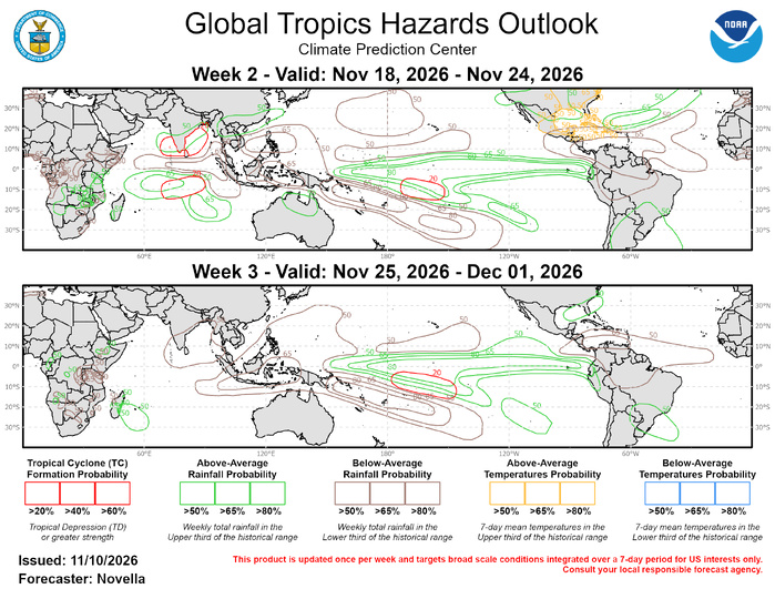
The precipitation outlook for weeks 2 and 3 is based on potential TC activity, composites of ENSO (with some consideration of MJO composites), and a skill weighted consolidated blend of ECMWF, GEFS, and CFSv2 ensemble mean solutions. Above-normal, but non-hazardous temperatures are favored for much of the central and eastern CONUS. For hazardous weather concerns in your area in the coming weeks, please refer to your local NWS, the Medium Range Hazards Forecast produced by the Weather Prediction Center, and the CPC Week-2 Hazards Outlook. Forecasts made over Africa are made in coordination with the International Desk at CPC, and can represent local-scale conditions in addition to global-scale variability.