

JTWC PH
JTWC FACEBOOK
Joint Typhoon Warning Center
National Hurricane Center
GTH Outlook Discussion
Last Updated - 09/22/26
Valid - 09/30/26 - 10/13/26
El Nino continues to dominate the global tropics, which is supported by persistently enhanced convective and circulation anomalies in response to a highly anomalous warm water volume in the equatorial Pacific. The latest weekly Relative Oceanic Nino Index (RONI) value has recently surpassed the 2 degree C threshold, classifying the ongoing El Nino as a 'very strong' and likely an historical intraseasonal event. Amid this powerful background state, MJO activity continues to be difficult to discern, though there are continued indications in the subseasonal tools for an ongoing Western Hemispheric event. Based on objective wave filtering of zonal wind and upper-level velocity potential anomaly fields, there are two subseasonal signals. One remains embedded within the low frequency suppressed convective envelope over the Eastern Hemisphere, and a more prominent, secondary signal shifting eastward across the Western Hemisphere, which is better projecting onto the RMM index.
Looking ahead, the majority of dynamical models favor an eastward propagating MJO over the Western Hemisphere, followed by a westward retreat of the signal closer to the western Pacific. The ECMWF, on the other hand, remains an interesting outlier, and instead favors a more progressive MJO that reaches the Indian Ocean at a moderate amplitude. A higher amplitude RMM signal favored over the Indian Ocean is potentially significant. Low RMM2 values have not been observed in months, and it possibly points to the secondary MJO signal attempting to become better separated from the dominant low frequency background state. This is supported in the lower-level zonal wind forecasts focused north of the equator, which depict a band of anomalous westerlies breaking through the low frequency footprint of enhanced trades centered approximately between 120W and 80W. This is expected to weaken the intense El Nino shearing regime over Mexico, Gulf of America, and parts of the Caribbean favorable for Tropical Cyclone (TC) development. In addition, the more progressive signal favored in the ECMWF may also be tied to an emerging positive Indian Ocean Dipole (+IOD) response which is also supported by its velocity potential forecasts depicting more enhanced divergence aloft over Africa where it has typically been suppressed due to the El Nino. Despite these developments in the ECMWF, there is still a good deal of uncertainty in the outlook given the more westward focused GEFS and CFSv2 subseasonal outlooks. This uncertainty is also reinforced by a favored regeneration of the background state in the guidance, which would act to reposition the main convective envelope over the equatorial Pacific towards the middle of October..
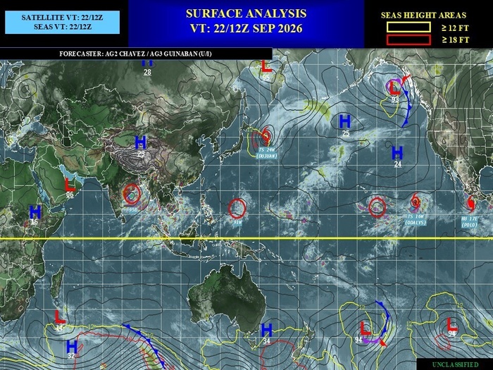
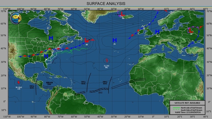
Three TCs developed during the past week, with one remaining active in the western Pacific from the week prior. Since forming on 9/15, TC Dujuan (24W) tracked westward into the northern Philippine Sea while strengthening to a Category 1 strength storm over the past weekend. Currently rounding a subtropical ridge and turning eastward offshore of Honshu, Japan, the Joint Typhoon Warning Center (JTWC) expects Dujuan to weaken and undergo extratropical transition in the next day or so. Its absorption into the extratropical westerlies looks to amplify the mid-level pattern over the northern Pacific, and potentially force a deep trough off the West Coast of the U.S. later this week. In the eastern Pacific, TCs Odalys and Polo formed on 9/20 and 9/21, near 11N/124W and 14N/105W, respectively. Polo is the first TC to form east of 105W since Genevieve in July, and experienced rapid intensification during the past 24 hours where it is currently a category 5 Major Hurricane. The National Hurricane Center (NHC) expects Polo to turn to the northwest and track near the Gulf of California. Combined with a mid-level trough off the coast of Baja California during the next few days, ample moisture advection is favored over the western and central CONUS during week-1, with heavy precipitation amounts forecast (in excess of 2-3 inches) over the eastern Four Corners which could trigger flooding over parts of New Mexico and adjacent parts of Texas. Meanwhile, TC Odalys is forecast to strengthen to a Category 1 Hurricane, and take a northeasterly track due the aforementioned troughing off the West Coast of the U.S. The NHC notes high uncertainty with the eventual tracks of either Odalys and Polo by later this week, as several deterministic solutions continue to feature a binary interaction as the two draw closer to one another. In the Atlantic, TC Fay formed on 9/19 near 33N/111W and reached Tropical Storm intensity over the weekend. Fay has turned back to the west, and downgraded to a Tropical Depression where it is eventually expected to dissipate into an open trough later this week as it encounters a more hostile environment.
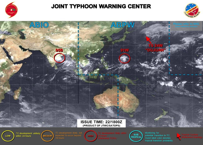
For week-1, the JTWC is monitoring two areas for potential TC development, one located in the Bay of Bengal (Invest 95B) and the other located near the Marianas (Invest 91W) both with high chances of development within the next day or so. In the western Hemisphere, the NHC is monitoring three areas for development during the next week. One is located to the southeast of Hawaii (Invest 15E) with 90% chances of formation, and is associated with the remnants of Tropical Depression 15 which had initially formed back on 9/13 over the eastern part of the basin. Regardless of the exact track of this disturbance, ensemble guidance shows the potential for heavy precipitation with flooding possible across many parts of Hawaii during week-1. The second NHC watch area is located closer to Mexico where there are 60% chances of additional TC development in the wake of TC Polo during the next week. Regardless of formation, ensemble solutions favor this disturbance taking a similar track to that of TC Polo, which could bring either a reinforcement or a secondary shot of tropical moisture into the southwestern CONUS during the week-2 period. Across the Atlantic, models have been consistent in featuring a tropical wave moving into the eastern Main Development Region (MDR) of the tropical Atlantic, where there are 30% chances for development near the Cabo Verde Islands.
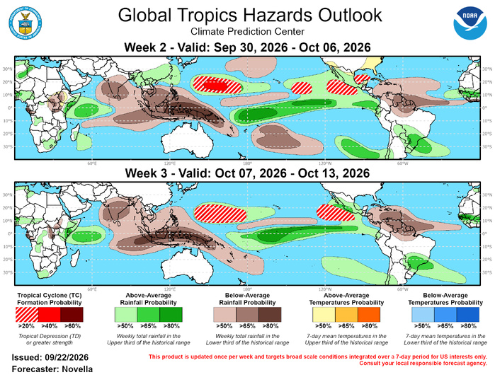
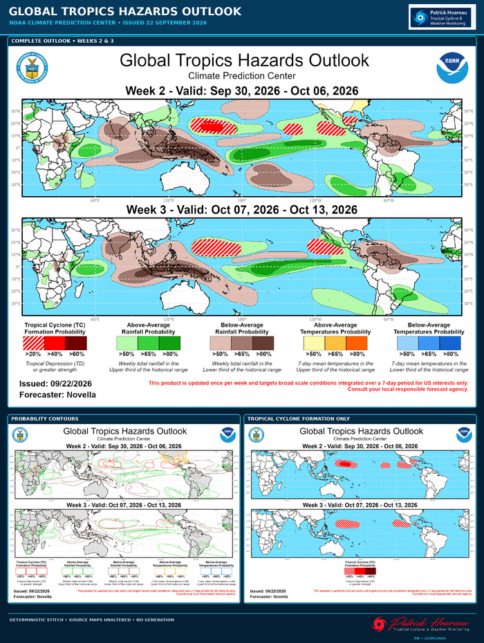
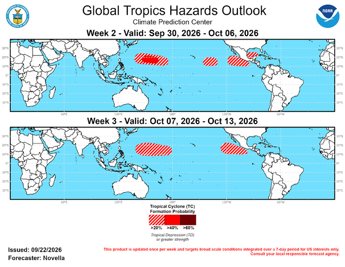
For the updated TC outlook, 40% chances of development are posted mainly to the east of the Marianas, with a broader area of 20% chances from approximately 140E to just west of the Date Line based on good support in the ensembles and probabilistic tools for additional development during the early to middle portion of week-2. In the central and eastern Pacific, the week-2 probabilistic TC guidance is quite busy due to existing TC activity from week-1, though there is coherent signal in the tools for additional formation between 140W and 130W in the wake of TC Odalys supporting 20% chances for development for week-2. In addition, due to the favored eastward advancement of the enhanced westerly regime to reduce shear over the tropical Americas, another 20% area is posted in the eastern Pacific with increased coverage closer to Mexico, as well as 20% chances posted in the southwestern Gulf of America where the ECMWF ensemble and Google AI to show a number of deepening lows supportive of development. Despite the uncertainties associated with the MJO by week-3, the large-scale environment is expected to remain favorable for additional TC development in the western Pacific, and a broad area of 20% chances of TC formation are posted, similar to the week-2 coverage. Likewise, 20% are again posted in the eastern Pacific closer to Mexico for week-3 based on decent support in the extended range probabilistic TC tools. While shearing environment is expected to become slightly less hostile in the eastern MDR, no TC genesis areas are posted based on a lack of support in the extended range TC tools as well as climatology becoming less active over this part of the basin later in October.
JTWC FACEBOOK
Joint Typhoon Warning Center
National Hurricane Center
GTH Outlook Discussion
Last Updated - 09/22/26
Valid - 09/30/26 - 10/13/26
El Nino continues to dominate the global tropics, which is supported by persistently enhanced convective and circulation anomalies in response to a highly anomalous warm water volume in the equatorial Pacific. The latest weekly Relative Oceanic Nino Index (RONI) value has recently surpassed the 2 degree C threshold, classifying the ongoing El Nino as a 'very strong' and likely an historical intraseasonal event. Amid this powerful background state, MJO activity continues to be difficult to discern, though there are continued indications in the subseasonal tools for an ongoing Western Hemispheric event. Based on objective wave filtering of zonal wind and upper-level velocity potential anomaly fields, there are two subseasonal signals. One remains embedded within the low frequency suppressed convective envelope over the Eastern Hemisphere, and a more prominent, secondary signal shifting eastward across the Western Hemisphere, which is better projecting onto the RMM index.
Looking ahead, the majority of dynamical models favor an eastward propagating MJO over the Western Hemisphere, followed by a westward retreat of the signal closer to the western Pacific. The ECMWF, on the other hand, remains an interesting outlier, and instead favors a more progressive MJO that reaches the Indian Ocean at a moderate amplitude. A higher amplitude RMM signal favored over the Indian Ocean is potentially significant. Low RMM2 values have not been observed in months, and it possibly points to the secondary MJO signal attempting to become better separated from the dominant low frequency background state. This is supported in the lower-level zonal wind forecasts focused north of the equator, which depict a band of anomalous westerlies breaking through the low frequency footprint of enhanced trades centered approximately between 120W and 80W. This is expected to weaken the intense El Nino shearing regime over Mexico, Gulf of America, and parts of the Caribbean favorable for Tropical Cyclone (TC) development. In addition, the more progressive signal favored in the ECMWF may also be tied to an emerging positive Indian Ocean Dipole (+IOD) response which is also supported by its velocity potential forecasts depicting more enhanced divergence aloft over Africa where it has typically been suppressed due to the El Nino. Despite these developments in the ECMWF, there is still a good deal of uncertainty in the outlook given the more westward focused GEFS and CFSv2 subseasonal outlooks. This uncertainty is also reinforced by a favored regeneration of the background state in the guidance, which would act to reposition the main convective envelope over the equatorial Pacific towards the middle of October..
Three TCs developed during the past week, with one remaining active in the western Pacific from the week prior. Since forming on 9/15, TC Dujuan (24W) tracked westward into the northern Philippine Sea while strengthening to a Category 1 strength storm over the past weekend. Currently rounding a subtropical ridge and turning eastward offshore of Honshu, Japan, the Joint Typhoon Warning Center (JTWC) expects Dujuan to weaken and undergo extratropical transition in the next day or so. Its absorption into the extratropical westerlies looks to amplify the mid-level pattern over the northern Pacific, and potentially force a deep trough off the West Coast of the U.S. later this week. In the eastern Pacific, TCs Odalys and Polo formed on 9/20 and 9/21, near 11N/124W and 14N/105W, respectively. Polo is the first TC to form east of 105W since Genevieve in July, and experienced rapid intensification during the past 24 hours where it is currently a category 5 Major Hurricane. The National Hurricane Center (NHC) expects Polo to turn to the northwest and track near the Gulf of California. Combined with a mid-level trough off the coast of Baja California during the next few days, ample moisture advection is favored over the western and central CONUS during week-1, with heavy precipitation amounts forecast (in excess of 2-3 inches) over the eastern Four Corners which could trigger flooding over parts of New Mexico and adjacent parts of Texas. Meanwhile, TC Odalys is forecast to strengthen to a Category 1 Hurricane, and take a northeasterly track due the aforementioned troughing off the West Coast of the U.S. The NHC notes high uncertainty with the eventual tracks of either Odalys and Polo by later this week, as several deterministic solutions continue to feature a binary interaction as the two draw closer to one another. In the Atlantic, TC Fay formed on 9/19 near 33N/111W and reached Tropical Storm intensity over the weekend. Fay has turned back to the west, and downgraded to a Tropical Depression where it is eventually expected to dissipate into an open trough later this week as it encounters a more hostile environment.
For week-1, the JTWC is monitoring two areas for potential TC development, one located in the Bay of Bengal (Invest 95B) and the other located near the Marianas (Invest 91W) both with high chances of development within the next day or so. In the western Hemisphere, the NHC is monitoring three areas for development during the next week. One is located to the southeast of Hawaii (Invest 15E) with 90% chances of formation, and is associated with the remnants of Tropical Depression 15 which had initially formed back on 9/13 over the eastern part of the basin. Regardless of the exact track of this disturbance, ensemble guidance shows the potential for heavy precipitation with flooding possible across many parts of Hawaii during week-1. The second NHC watch area is located closer to Mexico where there are 60% chances of additional TC development in the wake of TC Polo during the next week. Regardless of formation, ensemble solutions favor this disturbance taking a similar track to that of TC Polo, which could bring either a reinforcement or a secondary shot of tropical moisture into the southwestern CONUS during the week-2 period. Across the Atlantic, models have been consistent in featuring a tropical wave moving into the eastern Main Development Region (MDR) of the tropical Atlantic, where there are 30% chances for development near the Cabo Verde Islands.
For the updated TC outlook, 40% chances of development are posted mainly to the east of the Marianas, with a broader area of 20% chances from approximately 140E to just west of the Date Line based on good support in the ensembles and probabilistic tools for additional development during the early to middle portion of week-2. In the central and eastern Pacific, the week-2 probabilistic TC guidance is quite busy due to existing TC activity from week-1, though there is coherent signal in the tools for additional formation between 140W and 130W in the wake of TC Odalys supporting 20% chances for development for week-2. In addition, due to the favored eastward advancement of the enhanced westerly regime to reduce shear over the tropical Americas, another 20% area is posted in the eastern Pacific with increased coverage closer to Mexico, as well as 20% chances posted in the southwestern Gulf of America where the ECMWF ensemble and Google AI to show a number of deepening lows supportive of development. Despite the uncertainties associated with the MJO by week-3, the large-scale environment is expected to remain favorable for additional TC development in the western Pacific, and a broad area of 20% chances of TC formation are posted, similar to the week-2 coverage. Likewise, 20% are again posted in the eastern Pacific closer to Mexico for week-3 based on decent support in the extended range probabilistic TC tools. While shearing environment is expected to become slightly less hostile in the eastern MDR, no TC genesis areas are posted based on a lack of support in the extended range TC tools as well as climatology becoming less active over this part of the basin later in October.

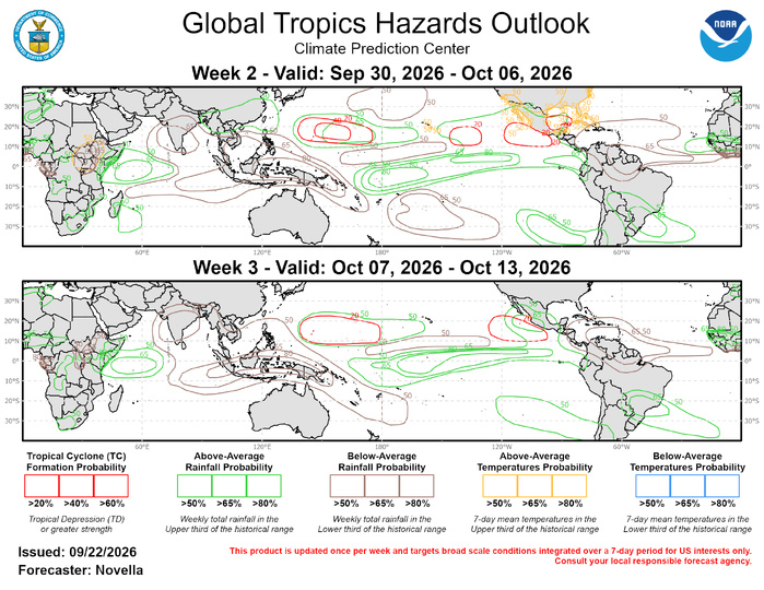
The precipitation outlook for weeks 2 and 3 is primarily based on a skill weighted consolidated blend of GEFS, CFS, and ECMWF ensemble forecast systems, El Nino composites, with some consideration of Western Hemispheric and Indian Ocean MJO event composites for Aug-Oct. For hazardous weather concerns in your area during the next two weeks, please refer to your local NWS office, the Medium Range Hazards Forecast from the Weather Prediction Center (WPC), and the CPC Week-2 Hazards Outlook. Forecasts issued over Africa are made in coordination with the International Desk at CPC.