

CLICK ON THE IMAGERIES BELOW TO GET THEM ENLARGED

JTWC PH
JTWC FACEBOOK
Joint Typhoon Warning Center
National Hurricane Center
10/27/2026
10/20/2026
10/13/2026
10/06/2026
09/29/2026
09/22/2026
GTH Outlook Discussion
Last Updated - 11/03/26
Valid - 11/11/26 - 11/24/26
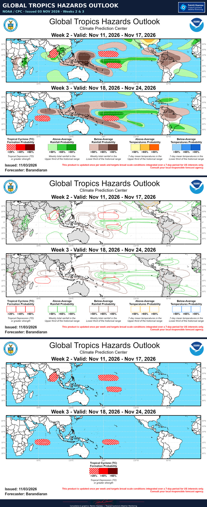
El Nino continues to dominate the global tropics, evidenced by very strong and persistent convective and circulation anomalies in response to a highly anomalous warm water volume in the equatorial Pacific. MJO activity remains difficult to discern within the background state, however there is some support in the tools for an ongoing positive Indian Ocean Dipole (+IOD) event. Dynamical models generally feature a strengthening but nearly stationary MJO signal over the Indian Ocean during week-1, but during the week-2 period and beyond the RMM-based model forecasts diverge significantly. The GEFS and BOMM models favor a fairly amplified solution and clear eastward propagation into the Western Pacific by the end of the forecast period. On the other hand, the ECMWF, JMA, and to a lesser extent the CFSv2 exhibit much less eastward propagation of the MJO, as well as a steady weakening of the signal, moving within the unit circle by week-3. Upper-level velocity potential maps from the ECMWF and GEFS show better agreement and both indicate significant destructive interference between the MJO and the standing El Nino base state during the week 2-3 period, although differences in timing and strength of the interaction vary in this analysis as well. Regardless, the El Nino footprint remains the major player over the tropical Pacific, while lingering MJO activity in the Indian Ocean during week-2 may enhance tropical cyclone (TC) activity in the Bay of Bengal.
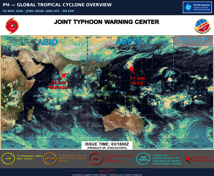
Two TCs formed over the last week, both over the Bay of Bengal (BoB). On October 26, the Joint Typhoon Warning Center (JTWC) began monitoring a tropical disturbance in the western BoB, which underwent a Fujiwhara interaction and became absorbed by TC Arnab, which had formed the previous week. JTWC has retroactively designated the system as TC 03B. Also in the BoB, TC Mursau formed in the eastern portion of the basin on Nov 1. Murasu has tracked westward across the basin and is nearing landfall along the southeastern coast of India. For the latest information on TC Murasu please refer to the JTWC.
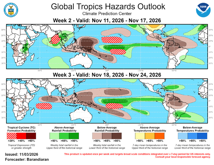
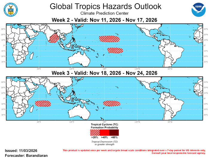
Model guidance generally favors enhanced TC activity in the Indian Ocean during the forecast period. During week-2 both the GEFS and ECMWF show increased signal over the BoB possibly due to support from lingering MJO activity. The Google AI TC model has been less bullish over the Indian Ocean over the last few days, slightly reducing forecast confidence, but there is sufficient model support to warrant a 20-40% chance of TC genesis over the BoB during week-2. Model guidance is much more bullish over the Central Pacific on both sides of the Equator during week-2, both from the dynamical models as well as AI-informed models, particularly early in week-2. Google’s AI model is particularly robust in week-2 north of the Equator, indicating a burst of potential TC activity at the outset of the forecast period. This signal is likely associated with an area of disturbed weather already being monitored by the National Hurricane Center, which has a 70% chance of formation over the next 7 days. Given the indication of a slow development in some of the model guidance, a 20-40% chance of TC genesis is posted for a broad area from roughly the Date Line east to the waters south of Hawaii, and an additional area with a 20-40% chance of TC genesis is posted for the South Pacific from 5-15S and 145-175W. During week-3, signal strength from a variety of guidance tools becomes weaker in the Northern Hemisphere. Tool support remains steady in the South Pacific, while ECMWF extended-range TC guidance shows an uptick in potential TC activity in the southern Indian Ocean. For week-3, a 20-40% chance of TC genesis remains posted for the South Pacific for the same region as week-2, with a slight westward extension to the Date Line, while a 20-40% chance of TC genesis is indicated for the southern Indian Ocean from 5-15S and 55-85E.
JTWC FACEBOOK
Joint Typhoon Warning Center
National Hurricane Center
10/27/2026
10/20/2026
10/13/2026
10/06/2026
09/29/2026
09/22/2026
GTH Outlook Discussion
Last Updated - 11/03/26
Valid - 11/11/26 - 11/24/26
El Nino continues to dominate the global tropics, evidenced by very strong and persistent convective and circulation anomalies in response to a highly anomalous warm water volume in the equatorial Pacific. MJO activity remains difficult to discern within the background state, however there is some support in the tools for an ongoing positive Indian Ocean Dipole (+IOD) event. Dynamical models generally feature a strengthening but nearly stationary MJO signal over the Indian Ocean during week-1, but during the week-2 period and beyond the RMM-based model forecasts diverge significantly. The GEFS and BOMM models favor a fairly amplified solution and clear eastward propagation into the Western Pacific by the end of the forecast period. On the other hand, the ECMWF, JMA, and to a lesser extent the CFSv2 exhibit much less eastward propagation of the MJO, as well as a steady weakening of the signal, moving within the unit circle by week-3. Upper-level velocity potential maps from the ECMWF and GEFS show better agreement and both indicate significant destructive interference between the MJO and the standing El Nino base state during the week 2-3 period, although differences in timing and strength of the interaction vary in this analysis as well. Regardless, the El Nino footprint remains the major player over the tropical Pacific, while lingering MJO activity in the Indian Ocean during week-2 may enhance tropical cyclone (TC) activity in the Bay of Bengal.
Two TCs formed over the last week, both over the Bay of Bengal (BoB). On October 26, the Joint Typhoon Warning Center (JTWC) began monitoring a tropical disturbance in the western BoB, which underwent a Fujiwhara interaction and became absorbed by TC Arnab, which had formed the previous week. JTWC has retroactively designated the system as TC 03B. Also in the BoB, TC Mursau formed in the eastern portion of the basin on Nov 1. Murasu has tracked westward across the basin and is nearing landfall along the southeastern coast of India. For the latest information on TC Murasu please refer to the JTWC.
Model guidance generally favors enhanced TC activity in the Indian Ocean during the forecast period. During week-2 both the GEFS and ECMWF show increased signal over the BoB possibly due to support from lingering MJO activity. The Google AI TC model has been less bullish over the Indian Ocean over the last few days, slightly reducing forecast confidence, but there is sufficient model support to warrant a 20-40% chance of TC genesis over the BoB during week-2. Model guidance is much more bullish over the Central Pacific on both sides of the Equator during week-2, both from the dynamical models as well as AI-informed models, particularly early in week-2. Google’s AI model is particularly robust in week-2 north of the Equator, indicating a burst of potential TC activity at the outset of the forecast period. This signal is likely associated with an area of disturbed weather already being monitored by the National Hurricane Center, which has a 70% chance of formation over the next 7 days. Given the indication of a slow development in some of the model guidance, a 20-40% chance of TC genesis is posted for a broad area from roughly the Date Line east to the waters south of Hawaii, and an additional area with a 20-40% chance of TC genesis is posted for the South Pacific from 5-15S and 145-175W. During week-3, signal strength from a variety of guidance tools becomes weaker in the Northern Hemisphere. Tool support remains steady in the South Pacific, while ECMWF extended-range TC guidance shows an uptick in potential TC activity in the southern Indian Ocean. For week-3, a 20-40% chance of TC genesis remains posted for the South Pacific for the same region as week-2, with a slight westward extension to the Date Line, while a 20-40% chance of TC genesis is indicated for the southern Indian Ocean from 5-15S and 55-85E.

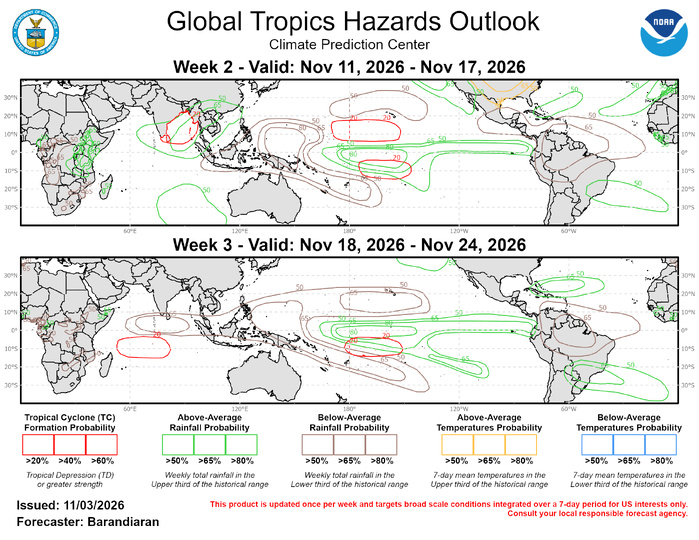
The precipitation outlook for weeks 2 and 3 is based on potential TC activity, ENSO composites, and informed by GEFS, CFS, Canadian, and ECMWF ensemble mean solutions. Above-normal temperatures are favored for much of the central Contiguous U.S. and along the Texas-Mexico border during week-2. For hazardous weather conditions in your area during the coming two-week period, please refer to your local NWS office, the Medium Range Hazards Forecast produced by the Weather Prediction Center, and the CPC Week-2 Hazards Outlook. Forecasts made over Africa are made in coordination with the International Desk at CPC