

CLICK ON THE IMAGERIES BELOW TO GET THEM ENLARGED

09/29/2026
09/22/2026
GTH Outlook Discussion
Last Updated - 10/06/26
Valid - 10/14/26 - 10/27/26
The global tropics continue to be dominated by El Nino with very strong and persistent convective and circulation anomalies in response to a highly anomalous warm water volume in the Equatorial Pacific. This is supported by a persistent wave-1 pattern in the global upper-level velocity potential since June featuring anomalous divergence (convergence) aloft over much of the Western (Eastern) Hemisphere. The Madden Julian Oscillation (MJO) is difficult to discern within the strong low frequency background state, but there has been some evidence of a weak intraseasonal signal in the Western Hemisphere during the past few months. The GEFS and ECMWF ensembles depict the RMM-based MJO index increasing in amplitude over the Indian Ocean during the next 2 weeks, with a tighter clustering in the ECMWF ensemble for a phase 2-3 event later in October, but more ensemble spread in the GEFS.
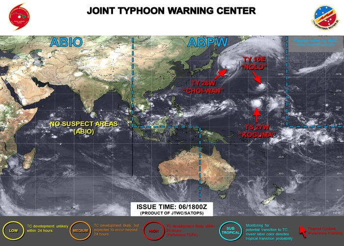
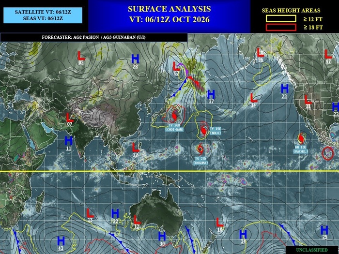
Increased tropical cyclone (TC) activity continues across the Pacific tied to El Nino. Two new systems have formed during the past week over the Western Pacific, Typhoon Choi-Wan (9/30) recurving east of Japan and Tropical Storm Koguma (10/5) which is tracking northwestward across the Western Pacific and is forecast to remain well northeast of Guam. In addition, Hurricane Nolo which originated over the Central Pacific has crossed the International Date Line, resulting in the new designation of Typhoon Nolo as it continues to track westward. Across the Eastern Pacific, Hurricane Rachel is weakening, however, its remnants are forecast to interact with troughing along the western U.S. coast. This will likely cause the system to turn back towards Baja California, favoring enhanced moisture advection over the southwestern U.S. later this week. The National Hurricane Center (NHC) is monitoring two additional systems to the south of Mexico and Central America with 90 and 20 percent formation odds respectively during the next week. The first system may ultimately track toward the Gulf of California, further enhancing moisture across the Desert Southwest.
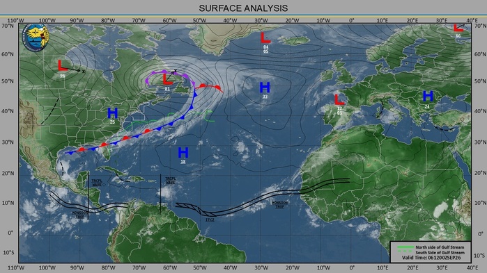
NHC is favoring development of the tropical disturbance over the Gulf of America with near 100 percent odds in the next 2 days. Dynamical models predict this system will track northward toward the Central Gulf Coast, although its strength remains uncertain. Regardless of how organized this system becomes, heavy rainfall is increasingly likely across portions of the Gulf Coast, Southeast, and Florida, and possibly extending farther north into much of the eastern U.S. this weekend into early next week.
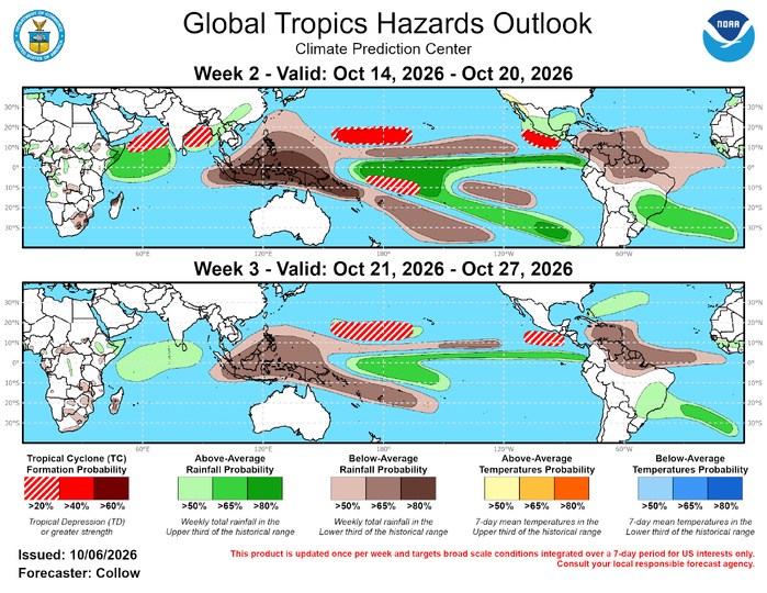
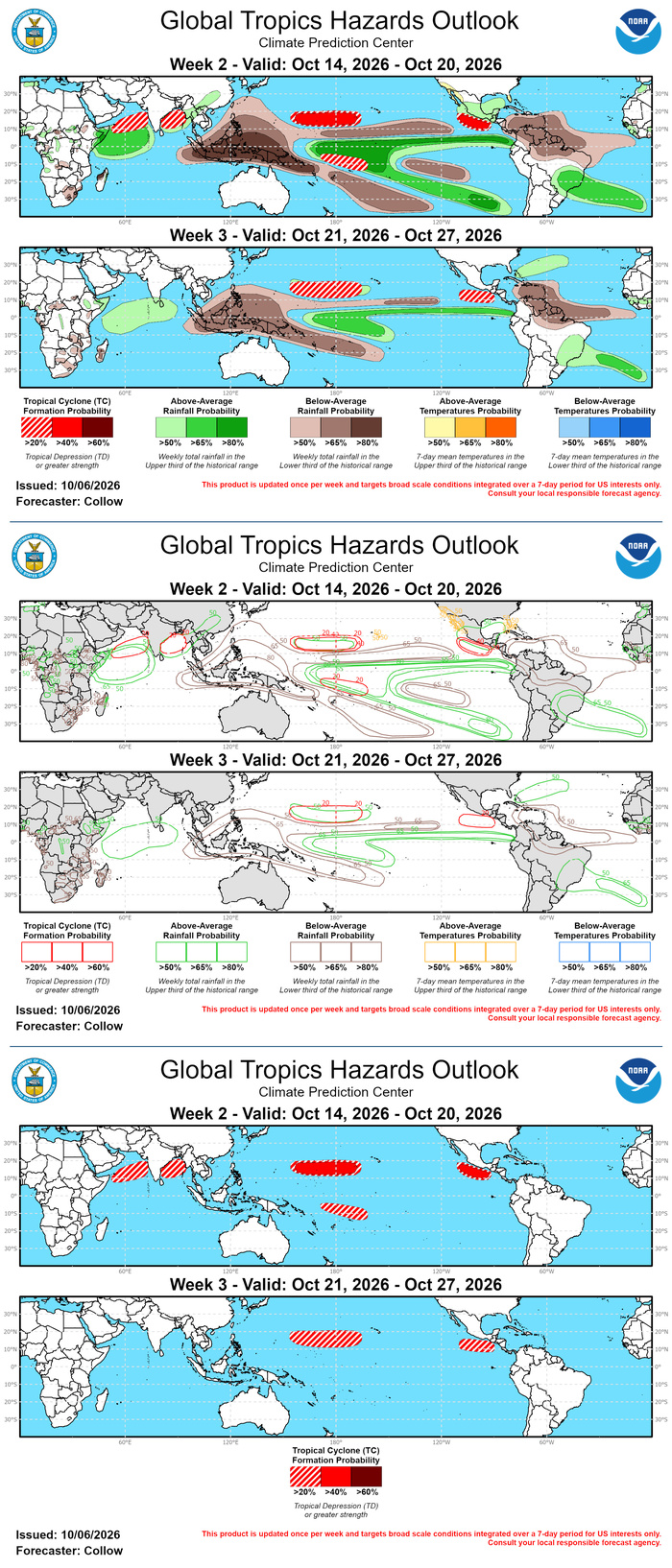
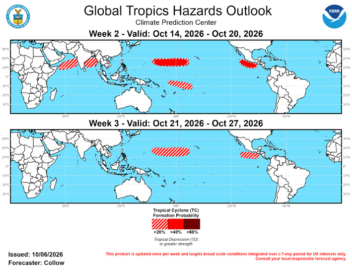
Going into weeks 2 and 3, increased TC activity is forecast to continue across the Pacific, with another formation possible to the south of Mexico. This could be the currently monitored low probability area by NHC being delayed or an additional system, with 40-60 percent odds being highlighted during week-2. TC formation probabilities of 40-60 percent are also indicated across the west-central Pacific due to persistent TC activity tied to El Nino and phase 2-3 MJO composites favoring a more eastward orientation of stronger TC formation probabilities. It is also not out of the question to have early season TC activity across the Southern Hemisphere near the Date Line, supported by an enhanced signal in the ECMWF ensembles and Google AI guidance. Given the favorable environment aloft, 20-40 percent chances are indicated for week-2 despite being outside of the typical climatology. The combination of a more amplified MJO signal and decreasing monsoonal activity favors 20-40 percent chances of TC formation across the Arabian Sea and Bay of Bengal during week-2. By week-3, declining seasonal climatology and weakening model signals result in lower probabilities for TC formation. However, there remains enough support for 20-40 percent odds across the west-central Pacific and the far eastern Pacific. There is little model support for additional TC formation across the Atlantic Basin beyond the current potential over the Gulf of America, with the ECMWF strike probability tool depicting negative anomalies over the Caribbean, a region which would normally be more favorable for cyclogenesis during late October.
09/22/2026
GTH Outlook Discussion
Last Updated - 10/06/26
Valid - 10/14/26 - 10/27/26
The global tropics continue to be dominated by El Nino with very strong and persistent convective and circulation anomalies in response to a highly anomalous warm water volume in the Equatorial Pacific. This is supported by a persistent wave-1 pattern in the global upper-level velocity potential since June featuring anomalous divergence (convergence) aloft over much of the Western (Eastern) Hemisphere. The Madden Julian Oscillation (MJO) is difficult to discern within the strong low frequency background state, but there has been some evidence of a weak intraseasonal signal in the Western Hemisphere during the past few months. The GEFS and ECMWF ensembles depict the RMM-based MJO index increasing in amplitude over the Indian Ocean during the next 2 weeks, with a tighter clustering in the ECMWF ensemble for a phase 2-3 event later in October, but more ensemble spread in the GEFS.
Increased tropical cyclone (TC) activity continues across the Pacific tied to El Nino. Two new systems have formed during the past week over the Western Pacific, Typhoon Choi-Wan (9/30) recurving east of Japan and Tropical Storm Koguma (10/5) which is tracking northwestward across the Western Pacific and is forecast to remain well northeast of Guam. In addition, Hurricane Nolo which originated over the Central Pacific has crossed the International Date Line, resulting in the new designation of Typhoon Nolo as it continues to track westward. Across the Eastern Pacific, Hurricane Rachel is weakening, however, its remnants are forecast to interact with troughing along the western U.S. coast. This will likely cause the system to turn back towards Baja California, favoring enhanced moisture advection over the southwestern U.S. later this week. The National Hurricane Center (NHC) is monitoring two additional systems to the south of Mexico and Central America with 90 and 20 percent formation odds respectively during the next week. The first system may ultimately track toward the Gulf of California, further enhancing moisture across the Desert Southwest.
NHC is favoring development of the tropical disturbance over the Gulf of America with near 100 percent odds in the next 2 days. Dynamical models predict this system will track northward toward the Central Gulf Coast, although its strength remains uncertain. Regardless of how organized this system becomes, heavy rainfall is increasingly likely across portions of the Gulf Coast, Southeast, and Florida, and possibly extending farther north into much of the eastern U.S. this weekend into early next week.
Going into weeks 2 and 3, increased TC activity is forecast to continue across the Pacific, with another formation possible to the south of Mexico. This could be the currently monitored low probability area by NHC being delayed or an additional system, with 40-60 percent odds being highlighted during week-2. TC formation probabilities of 40-60 percent are also indicated across the west-central Pacific due to persistent TC activity tied to El Nino and phase 2-3 MJO composites favoring a more eastward orientation of stronger TC formation probabilities. It is also not out of the question to have early season TC activity across the Southern Hemisphere near the Date Line, supported by an enhanced signal in the ECMWF ensembles and Google AI guidance. Given the favorable environment aloft, 20-40 percent chances are indicated for week-2 despite being outside of the typical climatology. The combination of a more amplified MJO signal and decreasing monsoonal activity favors 20-40 percent chances of TC formation across the Arabian Sea and Bay of Bengal during week-2. By week-3, declining seasonal climatology and weakening model signals result in lower probabilities for TC formation. However, there remains enough support for 20-40 percent odds across the west-central Pacific and the far eastern Pacific. There is little model support for additional TC formation across the Atlantic Basin beyond the current potential over the Gulf of America, with the ECMWF strike probability tool depicting negative anomalies over the Caribbean, a region which would normally be more favorable for cyclogenesis during late October.

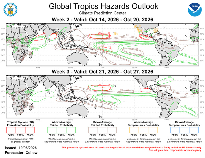
The precipitation outlook for weeks 2 and 3 is based on potential TC activity, ENSO composites, and informed by GEFS, CFS, Canadian, and ECMWF ensemble mean solutions. Below normal rainfall is forecast across the Maritime Continent and over portions of northern South America and the Caribbean. Above-normal rainfall is likely to persist across the Equatorial Pacific, with increasing chances over the Indian Ocean tied to the MJO. For hazardous weather conditions in your area during the coming two-week period, please refer to your local NWS office, the Medium Range Hazards Forecast produced by the Weather Prediction Center, and the CPC Week-2 Hazards Outlook. Forecasts made over Africa are made in coordination with the International Desk at CPC.