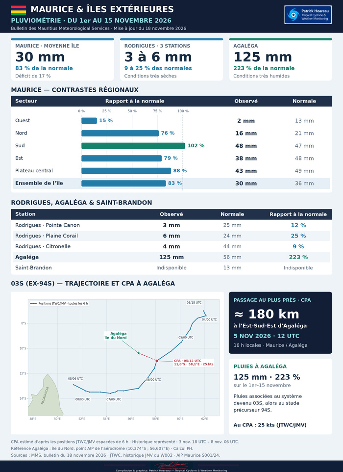
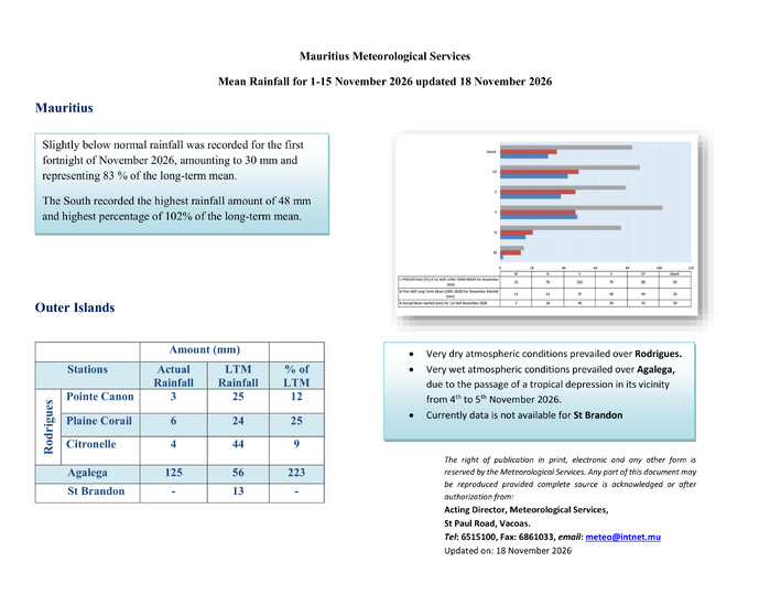
Îles Sœurs — Pluies du 1er au 15 novembre 2026 : Maurice légèrement déficitaire, Rodrigues très sèche et Agaléga sous l’influence de 03S
Bilan MMS : 30 mm à Maurice, soit 83 % de la normale, contre 125 mm et 223 % à Agaléga. Retrouvez également la trajectoire de 03S et son CPA estimé à environ 180 km à l’Est-Sud-Est d’Agaléga le 5 novembre.
Rédigé par PATRICK HOAREAU le Thursday, November 19th 2026 à 08:56
Ajouter un commentaire
Les News
Îles Sœurs — Pluies du 1er au 15 novembre 2026 : Maurice légèrement déficitaire, Rodrigues très sèche et Agaléga sous l’influence de 03S
11/19/2026
- PATRICK HOAREAU
11/18/26 0900 UTC: Tropical Cyclone 04P(XAVIER): 130 kts at peak — Super Typhoon Intensity / US CATEGORY 4 — exceeding all South Pacific November peaks in our 1981–2025 archive
11/18/2026
- PATRICK HOAREAU
11/17/26 0900 UTC: Tropical Cyclone 04P(XAVIER): Stunning Intensification from 55 to 125 kt-CAT 4 US in 24 Hours
11/17/2026
- PATRICK HOAREAU
Tropical Cyclones-Typhoons: JTWC 2025 Best Tracks — 71 Tropical Cyclone Tracks Across Three Regions
11/17/2026
- PATRICK HOAREAU
11/16/26 0300 UTC: TC 04P(XAVIER): 45 kt, US/CAT 1 forecast within 24h, Jtwc warning verifications and forecast trends
11/16/2026
- PATRICK HOAREAU
Tempêtes tropicales et cyclones à 100 km ou moins de Maurice, La Réunion, Rodrigues, Saint Brandon, Tromelin et Agaléga (1945–2024)
11/12/2026
- PATRICK HOAREAU
Liens utiles
11/18/26 0900 UTC: Tropical Cyclone 04P(XAVIER): 130 kts at peak — Super Typhoon Intensity / US CATEGORY 4 — exceeding all South Pacific November peaks in our 1981–2025 archive
11/17/26 0900 UTC: Tropical Cyclone 04P(XAVIER): Stunning Intensification from 55 to 125 kt-CAT 4 US in 24 Hours
Tropical Cyclones-Typhoons: JTWC 2025 Best Tracks — 71 Tropical Cyclone Tracks Across Three Regions
11/16/26 0300 UTC: TC 04P(XAVIER): 45 kt, US/CAT 1 forecast within 24h, Jtwc warning verifications and forecast trends
Southern Hemisphere Tropical Cyclones (1981–2024): Where, When and How Strong? BEING UPDATED
S'identifier