

CLICK ON THE IMAGERIES BELOW TO GET THEM ENLARGED

JTWC PH
JTWC FACEBOOK
Joint Typhoon Warning Center
National Hurricane Center
10/06/2026
09/29/2026
09/22/2026
GTH Outlook Discussion
Last Updated - 10/13/26
Valid - 10/21/26 - 11/03/26
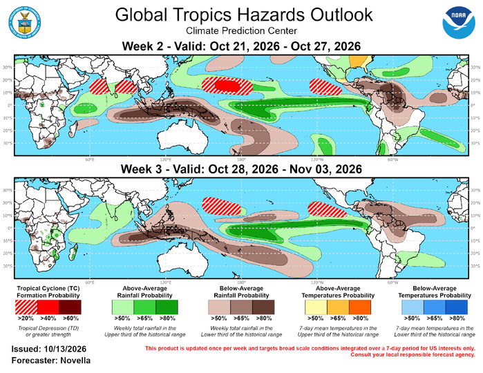
El Nino continues to overshadow any coherent MJO activity throughout the global tropics. A canonical low frequency atmospheric response to the markedly warm sea surface temperatures in the equatorial Pacific remains quite evident, though there are some signs of subseasonal activity embedded within these convective and circulation footprints. A notable subseasonal signal involves an eastward extension of the enhanced lower-level westerly wind regime focused north of the equator between 120W and 90W, which likely contributed to the development of multiple Tropical Cyclones (TCs) in the eastern Pacific during the past few weeks, as well as TC Isaias, the first Hurricane recorded in an otherwise very inactive Atlantic basin this season. The eastward propagating activity over the Western Hemisphere is featured in the RMM observations, though perhaps the more salient observation, at least from from an outlook perspective, is that the RMM index has struggled to fully propagate the MJO signal out of the Western Hemisphere (phases 8 and 1) since early September. Analysis of low-pass filtered RMMs depicts a noticeable shift in the background state, best characterized by the onset of enhanced trades over equatorial Africa and the Indian Ocean since early September. This points to the emergence of a positive Indian Ocean Dipole (+IOD) circulation which has likely contributed to the left-leaning signal in RMM space, since a novel low frequency signal would not be entirely captured in the 120-day mean removal in RMM computation.
Looking ahead, dynamical models feature an MJO signal reaching the Indian Ocean, with the ECMWF favoring a high amplitude event in RMM phase space. However, this has been a repeated forecast never realized over the past few weeks, and given the lack of sustained eastward propagation in the latest ensemble members across the Indian Ocean and into the Maritime Continent, it appears more likely that models may be latching more onto the +IOD response, rather than MJO activity in the RMM forecasts. This is supported by objectively wave-filtered OLR and upper-level velocity potential anomaly forecasts, which favor a low frequency convective signal becoming better established over the Indian Ocean, resulting in the development of a wave-2 pattern throughout the global tropics through early November. Therefore, the updated GTH outlook relies more on the increasingly active convective regime over parts of the Indian Ocean, as well as the ongoing El Nino in the equatorial Pacific, where the favored continuation of enhanced low-level westerlies and reduced shearing looks to maintain a favorable environment for additional tropical cyclogenesis across the basin.
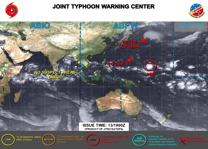
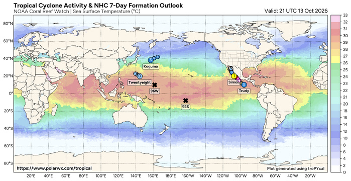
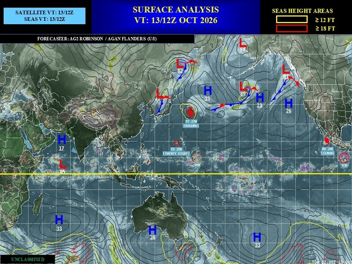
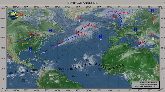
During the past seven days, four Tropical Cyclones (TCs) formed with TC Isaias forming in the Bay of Campeche shortly after the issuance of the GTH outlook last week (10/6). Being the latest first Hurricane on record during the satellite data era (post-1966) for the Atlantic, Isaias underwent rapid intensification over the Gulf of America and made landfall over the Florida panhandle as a category 2 system. Widespread adverse impacts were reported throughout the eastern U.S. as the system became post-tropical and dissipated over the Tennessee and Ohio Valleys on 10/11. In the eastern Pacific, TC Simon formed on 10/7 near 13N/100W to the south of Mexico and also experienced rapid intensification, peaking as a category 4 system as it tracked northward towards the Gulf of California while bringing heavy rainfall, flooding and large swells near western Mexico over the past weekend. The National Hurricane Center (NHC) forecasts Simon to gradually weaken due to dry air intrusions given its proximity to land and make landfall over western Mexico later this week. With a deep mid-level trough established over the western CONUS to pull Simon northward, the advection of ample tropical moisture is poised to overspread the western and central CONUS, along with combined added moisture from the remnants of TC Rachel, which made landfall over the southwestern CONUS this past weekend. In the wake of Simon, TD21 formed on 10/13 near 10N/97W. The NHC forecasts this system to soon become a Tropical Storm and reach Major Hurricane intensity while tracking northwestward towards southern Mexico later this week. For future updates on the system, please refer to the NHC at: https://www.nhc.noaa.gov/ . In the western Pacific, TD28 formed on 10/12 near 14N/146E over the northern Marianas. The Joint Typhoon Warning Center (JTWC) expects this system to remain at tropical depression intensity due to ambient dry air limiting further development while tracking northwestward and dissipating later this week. To the north of TD28, TC Koguma remains active since forming back on 10/5 to the west of the Date Line. This system is currently rounding a subtropical ridge in the northern Pacific, and the JTWC forecasts continued weakening of the system during the next several days as it eventually becomes absorbed in the extratropical westerlies.
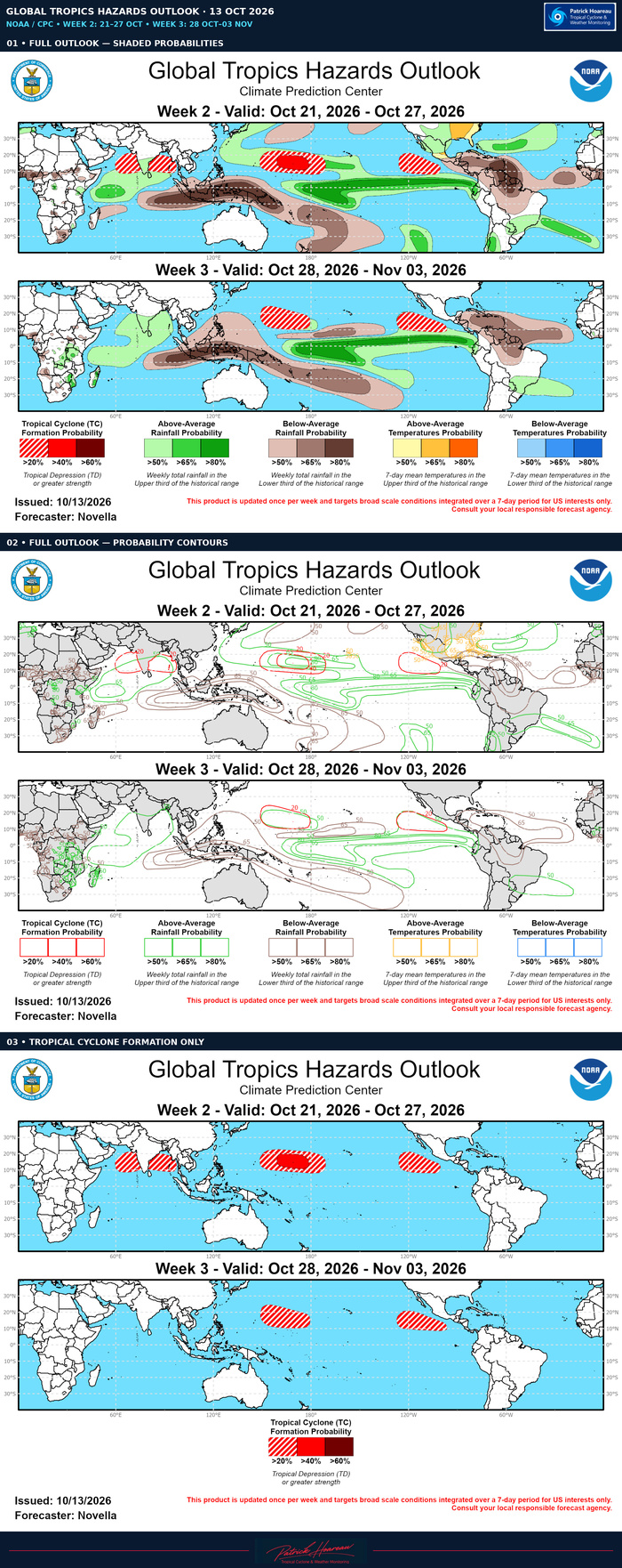
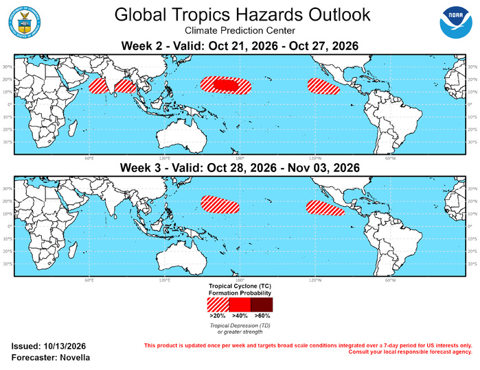
In the western hemisphere, probabilistic TC tools feature renewed activity signals between 120W and 90W in the wake of TD21, as well as another area in the Bay of Campeche towards the start of the week-2 period. However, the aforementioned subseasonal forcing at the lower-levels is expected to no longer be a factor over this part of tropics, as enhanced trades are beginning to develop north of the equator, lowering outlook confidence for additional TC formation. Therefore, 20% chances are issued to the southwest of Mexico, and no corresponding TC shapes are posted for the Gulf in the Atlantic basin for week-2. Additional TC development is also possible over the subtropical Atlantic where tools maintain modest chances for development. However, no TC-related areas are posted due to large spread in the guidance and high uncertainty as to whether any low that forms will develop subtropical or tropical characteristics. For week-3, 20% chances are again posted across the eastern Pacific where there is some support in the extended range tools for additional development tied to low frequency anomalous westerlies favored closer to the equator.
Across the eastern hemisphere, the JTWC is eyeing an area (Invest 96W) located in the eastern part of the western Pacific basin with moderate chances of development during the next few days. Behind this potential system, probabilistic TC tools have been consistent in depicting a broad area of regenerating signals between 155W and the Date Line by early week-2. Consistent with previous TC development over this part of the basin tied to the ongoing El Nino, 40% chances are posted with a broader area of 20% chances for week-2. For week-3, another 20% area is likewise issued for the eastern portion of the basin where enhanced lower-level westerlies and lowered shear are favored to persist in the extended range guidance. In the northern Indian Ocean, 20% chances for TC development are posted over the Arabian Sea and the Bay of Bengal which is supported in the probabilistic tools, and is consistent with the climatological uptick in TC formation following the cessation of the Indian monsoon and related shearing.
JTWC FACEBOOK
Joint Typhoon Warning Center
National Hurricane Center
10/06/2026
09/29/2026
09/22/2026
GTH Outlook Discussion
Last Updated - 10/13/26
Valid - 10/21/26 - 11/03/26
El Nino continues to overshadow any coherent MJO activity throughout the global tropics. A canonical low frequency atmospheric response to the markedly warm sea surface temperatures in the equatorial Pacific remains quite evident, though there are some signs of subseasonal activity embedded within these convective and circulation footprints. A notable subseasonal signal involves an eastward extension of the enhanced lower-level westerly wind regime focused north of the equator between 120W and 90W, which likely contributed to the development of multiple Tropical Cyclones (TCs) in the eastern Pacific during the past few weeks, as well as TC Isaias, the first Hurricane recorded in an otherwise very inactive Atlantic basin this season. The eastward propagating activity over the Western Hemisphere is featured in the RMM observations, though perhaps the more salient observation, at least from from an outlook perspective, is that the RMM index has struggled to fully propagate the MJO signal out of the Western Hemisphere (phases 8 and 1) since early September. Analysis of low-pass filtered RMMs depicts a noticeable shift in the background state, best characterized by the onset of enhanced trades over equatorial Africa and the Indian Ocean since early September. This points to the emergence of a positive Indian Ocean Dipole (+IOD) circulation which has likely contributed to the left-leaning signal in RMM space, since a novel low frequency signal would not be entirely captured in the 120-day mean removal in RMM computation.
Looking ahead, dynamical models feature an MJO signal reaching the Indian Ocean, with the ECMWF favoring a high amplitude event in RMM phase space. However, this has been a repeated forecast never realized over the past few weeks, and given the lack of sustained eastward propagation in the latest ensemble members across the Indian Ocean and into the Maritime Continent, it appears more likely that models may be latching more onto the +IOD response, rather than MJO activity in the RMM forecasts. This is supported by objectively wave-filtered OLR and upper-level velocity potential anomaly forecasts, which favor a low frequency convective signal becoming better established over the Indian Ocean, resulting in the development of a wave-2 pattern throughout the global tropics through early November. Therefore, the updated GTH outlook relies more on the increasingly active convective regime over parts of the Indian Ocean, as well as the ongoing El Nino in the equatorial Pacific, where the favored continuation of enhanced low-level westerlies and reduced shearing looks to maintain a favorable environment for additional tropical cyclogenesis across the basin.
During the past seven days, four Tropical Cyclones (TCs) formed with TC Isaias forming in the Bay of Campeche shortly after the issuance of the GTH outlook last week (10/6). Being the latest first Hurricane on record during the satellite data era (post-1966) for the Atlantic, Isaias underwent rapid intensification over the Gulf of America and made landfall over the Florida panhandle as a category 2 system. Widespread adverse impacts were reported throughout the eastern U.S. as the system became post-tropical and dissipated over the Tennessee and Ohio Valleys on 10/11. In the eastern Pacific, TC Simon formed on 10/7 near 13N/100W to the south of Mexico and also experienced rapid intensification, peaking as a category 4 system as it tracked northward towards the Gulf of California while bringing heavy rainfall, flooding and large swells near western Mexico over the past weekend. The National Hurricane Center (NHC) forecasts Simon to gradually weaken due to dry air intrusions given its proximity to land and make landfall over western Mexico later this week. With a deep mid-level trough established over the western CONUS to pull Simon northward, the advection of ample tropical moisture is poised to overspread the western and central CONUS, along with combined added moisture from the remnants of TC Rachel, which made landfall over the southwestern CONUS this past weekend. In the wake of Simon, TD21 formed on 10/13 near 10N/97W. The NHC forecasts this system to soon become a Tropical Storm and reach Major Hurricane intensity while tracking northwestward towards southern Mexico later this week. For future updates on the system, please refer to the NHC at: https://www.nhc.noaa.gov/ . In the western Pacific, TD28 formed on 10/12 near 14N/146E over the northern Marianas. The Joint Typhoon Warning Center (JTWC) expects this system to remain at tropical depression intensity due to ambient dry air limiting further development while tracking northwestward and dissipating later this week. To the north of TD28, TC Koguma remains active since forming back on 10/5 to the west of the Date Line. This system is currently rounding a subtropical ridge in the northern Pacific, and the JTWC forecasts continued weakening of the system during the next several days as it eventually becomes absorbed in the extratropical westerlies.
In the western hemisphere, probabilistic TC tools feature renewed activity signals between 120W and 90W in the wake of TD21, as well as another area in the Bay of Campeche towards the start of the week-2 period. However, the aforementioned subseasonal forcing at the lower-levels is expected to no longer be a factor over this part of tropics, as enhanced trades are beginning to develop north of the equator, lowering outlook confidence for additional TC formation. Therefore, 20% chances are issued to the southwest of Mexico, and no corresponding TC shapes are posted for the Gulf in the Atlantic basin for week-2. Additional TC development is also possible over the subtropical Atlantic where tools maintain modest chances for development. However, no TC-related areas are posted due to large spread in the guidance and high uncertainty as to whether any low that forms will develop subtropical or tropical characteristics. For week-3, 20% chances are again posted across the eastern Pacific where there is some support in the extended range tools for additional development tied to low frequency anomalous westerlies favored closer to the equator.
Across the eastern hemisphere, the JTWC is eyeing an area (Invest 96W) located in the eastern part of the western Pacific basin with moderate chances of development during the next few days. Behind this potential system, probabilistic TC tools have been consistent in depicting a broad area of regenerating signals between 155W and the Date Line by early week-2. Consistent with previous TC development over this part of the basin tied to the ongoing El Nino, 40% chances are posted with a broader area of 20% chances for week-2. For week-3, another 20% area is likewise issued for the eastern portion of the basin where enhanced lower-level westerlies and lowered shear are favored to persist in the extended range guidance. In the northern Indian Ocean, 20% chances for TC development are posted over the Arabian Sea and the Bay of Bengal which is supported in the probabilistic tools, and is consistent with the climatological uptick in TC formation following the cessation of the Indian monsoon and related shearing.

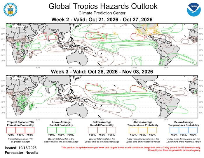
The precipitation outlook for week 2 and week-3 is based on potential TC activity, ENSO composites and informed by GEFS, CFSv2, and ECMWF ensemble mean solutions. Above-normal but non-hazardous temperatures are favored for much of the central and eastern CONUS. For hazardous weather conditions in your area in the coming weeks, please refer to your local NWS office, the Medium Range Hazards Forecast produced from the Weather Prediction Center, and the CPC Week-2 Hazards Outlook. Forecasts made over Africa are made in coordination with the International Desk at CPC.