

CLICK ON THE IMAGERIES BELOW TO GET THEM ENLARGED


02 NOVEMBER 2026 • 2100 UTC
TROPICAL CYCLONE 04B (MURASU) — US CATEGORY 2
Unexpected strengthening by an extremely compact cyclone approaching Andhra Pradesh
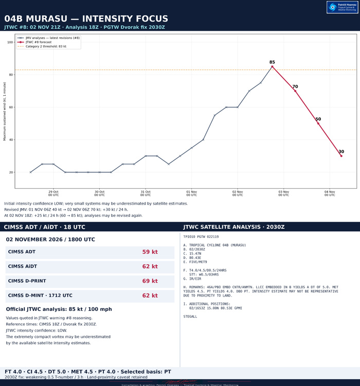
JTWC warning #08, issued at 2100 UTC on 2 November, raises MURASU to 85 kt / 100 mph, approximately 155–160 km/h, at the 1800 UTC analysis time. Minimum central pressure is 973 hPa and gusts are 105 kt, approximately 195 km/h. Maximum sustained winds use a one-minute average. The Category 2 designation refers to the US Saffir–Simpson wind scale.
The analysed centre is 15.1°N, 80.5°E, moving north-northwestward at 5 kt, approximately 9 km/h, along a heading of 340°. JTWC gives an extrapolated 2100 UTC position of 15.3°N, 80.4°E. These are different valid times. Significant wave height is 28 ft, approximately 8.5 m; this is not a storm-surge estimate or the height of the largest individual wave.
A MICROWAVE EYE AND A CLOSING EYEWALL
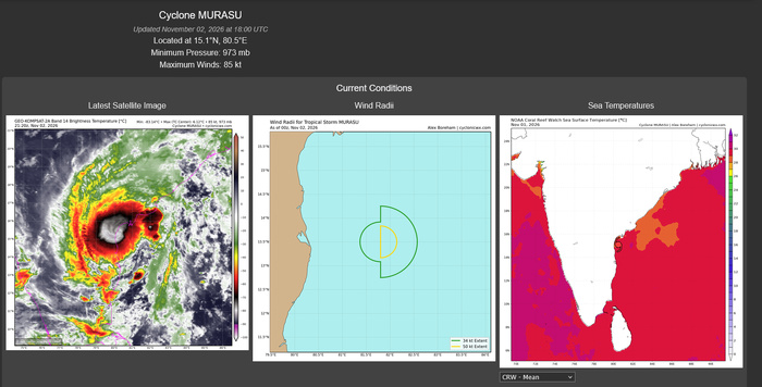
The cyclone retains an exceptionally compact central dense overcast, with cloud-top temperatures colder than −80°C. JTWC identifies an eye feature in the 1653 UTC GMI pass.
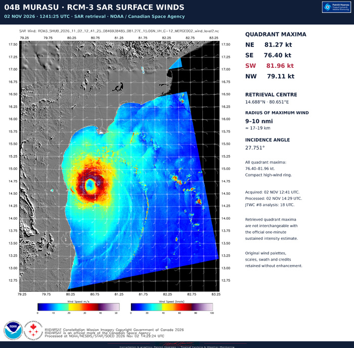
Radar imagery indicates that the previously open southwestern eyewall quadrant has closed. The CDO also tightened over the preceding six hours. Based on the 1241 UTC RCM-3 SAR pass and additional Dvorak analysis, JTWC retrospectively raised the 1200 UTC intensity to 75 kt. The 1536 UTC ASCAT-B and SAR observations support gale-force radii of only about 30–40 nautical miles.
The 85 kt analysis is explicitly uncertain: JTWC assigns LOW confidence to intensity, MEDIUM confidence to the centre position and HIGH confidence to the wind radii. The official intensity exceeds the available subjective and objective estimates, which may underestimate very small cyclones. The position accuracy specified in the warning is 30 nautical miles.
SATELLITE INTENSITY ESTIMATES LISTED BY JTWC
PGTW: T4.5 / 77 kt.
DEMS: T3.5 / 55 kt.
CIMSS ADT: 59 kt at 1800 UTC.
CIMSS AiDT: 62 kt at 1800 UTC.
CIMSS D-MINT: 62 kt at 1712 UTC.
CIMSS D-PRINT: 69 kt at 1800 UTC.
These are separate estimates; the official analysis is 85 kt. The microwave image depicts brightness temperature and inner-core structure, not a direct surface-wind measurement. Its original Kelvin scale, palette, swath, coastline and credits are retained.
OFFICIAL FORECAST — ANALYSIS TIME 02 NOVEMBER 1800 UTC
Hour | Valid time (UTC) | Centre | Maximum sustained wind | Gust
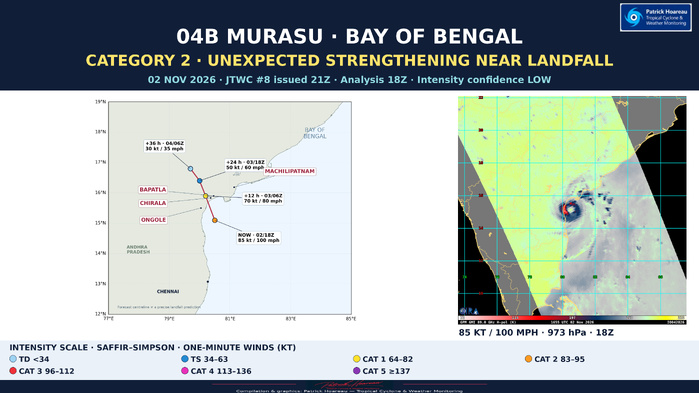
0 | 02 Nov 1800 | 15.1°N 80.5°E | 85 kt / 100 mph | 105 kt
12 | 03 Nov 0600 | 15.9°N 80.2°E | 70 kt / 80 mph | 85 kt
24 | 03 Nov 1800 | 16.4°N 80.0°E | 50 kt / 60 mph | 65 kt
36 | 04 Nov 0600 | 16.8°N 79.7°E | 30 kt / 35 mph | 40 kt
The system is forecast to move onshore by +12 hours, then weaken rapidly. By +24 hours it is dissipating inland, and by +36 hours it is dissipated as a significant tropical cyclone over land. The +12-hour forecast point is not an exact landfall time or location.
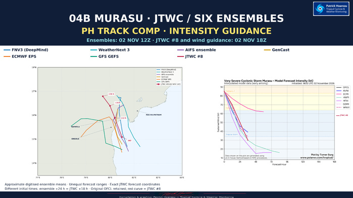
North-northwestward motion should continue around the southwestern flank of the subtropical ridge centred near 18°N, 91°E. As the vortex weakens and becomes shallow, lower-level easterly flow should produce a slight westward turn before dissipation.
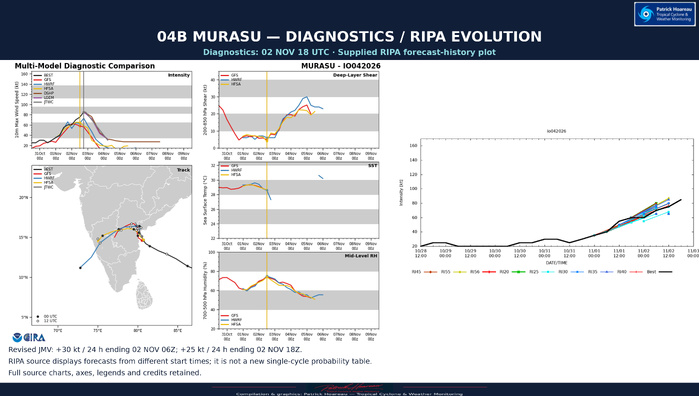
Sea-surface temperatures remain 29–30°C, but vertical wind shear has increased to 15–20 kt and land interaction is growing. Outflow is moderate poleward and westward. JTWC considers the remaining opportunity for further strengthening very limited, with weakening expected shortly and rapid weakening after landfall.
Track and intensity forecast confidence are both HIGH, distinct from the LOW confidence assigned to the current intensity. The official track lies near the centre of the guidance envelope. Dynamical models generally turn the system westward more sharply than the AI models. Intensity guidance unanimously weakens the cyclone; JTWC follows the core group comprising HAFS-A, Google DeepMind and COAMPS-TC.
JTWC TRENDS — THE STRENGTHENING WAS NOT CAPTURED BY WARNING #06
Warning #06, issued at 0900 UTC with a 0600 UTC initial analysis, forecast 65 kt at 1800 UTC. Warning #08 now analyses 85 kt at that same valid time: 20 kt higher than the earlier 12-hour forecast. The trend comparison uses exact positions and winds from the available archived warnings #03, #06 and #08, with intensity plotted by common valid time. It is a selected-cycle comparison, not an uninterrupted archive of every warning.
REVISION OF THE 24-HOUR INTENSIFICATION RECORD
The latest JMV accompanying warning #08 revises the 2 November 0600 UTC intensity to 70 kt, compared with 65 kt in warning #06. From 40 kt at 0600 UTC on 1 November to 70 kt at 0600 UTC on 2 November, the revised record now shows +30 kt in 24 hours, meeting the +30 kt/24-hour RI threshold used in our comparison.
The earlier +25 kt/24-hour conclusion therefore no longer holds for that window in the latest revised JMV. This is an important change. At the latest 1800 UTC endpoint, the 24-hour change is +25 kt, from 60 to 85 kt. Different rolling windows give different results, and these operational analyses remain subject to revision.
The delayed SAR acquisition of 1 November at 1232:39 UTC remains relevant to the earlier intensity peak: its northeastern quadrant maximum was 83.46 kt, with a reported RMax range of 6–9 nautical miles. The supplied latest JMV still assigns 55 kt at 1 November 1200 UTC. That SAR retrieval is not directly interchangeable with an official one-minute sustained intensity, but the discrepancy remains a reason to monitor subsequent JMV/JTWC revisions. It is a different acquisition from the 2 November 1241 UTC SAR pass cited in warning #08; the latter pass was not supplied with this focus.
JTWC +24-HOUR VERIFICATION
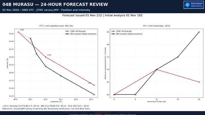
Available forecasts are checked against the latest revised JMV analyses contained in warning #08. Position error is the great-circle separation; signed intensity error is forecast minus verifying analysis. These are preliminary operational verifications, not final best-track results.
Warning #01, issued 01 Nov 0300 UTC:
Forecast +24 valid 02 Nov 0000 UTC: 14.0°N 82.2°E, 50 kt.
Verifying analysis: 13.9°N 81.5°E, 60 kt.
Position error: 76 km / 41 nautical miles. Wind error: −10 kt.
Warning #02, issued 01 Nov 0900 UTC:
Forecast +24 valid 02 Nov 0600 UTC: 14.5°N 80.7°E, 65 kt.
Verifying analysis: 14.2°N 81.0°E, 70 kt.
Position error: 46 km / 25 nautical miles. Wind error: −5 kt.
Warning #03, issued 01 Nov 1500 UTC:
Forecast +24 valid 02 Nov 1200 UTC: 14.8°N 80.5°E, 70 kt.
Verifying analysis: 14.6°N 80.7°E, 75 kt.
Position error: 31 km / 17 nautical miles. Wind error: −5 kt.
Warning #06's +24-hour forecast is valid at 03 November 0600 UTC and cannot yet be verified at this focus time. Verification uses the later revised JMV positions, whereas the Trends product retains each warning's initial analysis as originally issued.
OFFICIAL WIND RADII — NAUTICAL MILES, NE / SE / SW / NW
02 Nov 1800 UTC:
64 kt: 15 / 15 / 15 / 15.
50 kt: 25 / 25 / 20 / 20.
34 kt: 35 / 40 / 30 / 40.
03 Nov 0600 UTC forecast:
64 kt: 15 / 10 / 5 / 10.
50 kt: 20 / 20 / 10 / 15.
34 kt: 30 / 30 / 20 / 25.
Radii are valid over open water only. The small circulation concentrates the strongest winds near the centre; it does not remove rainfall or coastal hazards outside those radii. Local warnings should be followed for impacts and protective action.
Sources: supplied JTWC warning #08, prognostic reasoning and JMV; archived JTWC warnings #01, #02, #03 and #06; GPM GMI / RAMMB-CIRA microwave image; earlier supplied NOAA SAR information summary. The focus is fixed to the 02 November 2100 UTC issue and does not claim a later update.
Patrick Hoareau — Tropical Cyclone & Weather Monitoring
TROPICAL CYCLONE 04B (MURASU) — US CATEGORY 2
Unexpected strengthening by an extremely compact cyclone approaching Andhra Pradesh
JTWC warning #08, issued at 2100 UTC on 2 November, raises MURASU to 85 kt / 100 mph, approximately 155–160 km/h, at the 1800 UTC analysis time. Minimum central pressure is 973 hPa and gusts are 105 kt, approximately 195 km/h. Maximum sustained winds use a one-minute average. The Category 2 designation refers to the US Saffir–Simpson wind scale.
The analysed centre is 15.1°N, 80.5°E, moving north-northwestward at 5 kt, approximately 9 km/h, along a heading of 340°. JTWC gives an extrapolated 2100 UTC position of 15.3°N, 80.4°E. These are different valid times. Significant wave height is 28 ft, approximately 8.5 m; this is not a storm-surge estimate or the height of the largest individual wave.
A MICROWAVE EYE AND A CLOSING EYEWALL
The cyclone retains an exceptionally compact central dense overcast, with cloud-top temperatures colder than −80°C. JTWC identifies an eye feature in the 1653 UTC GMI pass.
Radar imagery indicates that the previously open southwestern eyewall quadrant has closed. The CDO also tightened over the preceding six hours. Based on the 1241 UTC RCM-3 SAR pass and additional Dvorak analysis, JTWC retrospectively raised the 1200 UTC intensity to 75 kt. The 1536 UTC ASCAT-B and SAR observations support gale-force radii of only about 30–40 nautical miles.
The 85 kt analysis is explicitly uncertain: JTWC assigns LOW confidence to intensity, MEDIUM confidence to the centre position and HIGH confidence to the wind radii. The official intensity exceeds the available subjective and objective estimates, which may underestimate very small cyclones. The position accuracy specified in the warning is 30 nautical miles.
SATELLITE INTENSITY ESTIMATES LISTED BY JTWC
PGTW: T4.5 / 77 kt.
DEMS: T3.5 / 55 kt.
CIMSS ADT: 59 kt at 1800 UTC.
CIMSS AiDT: 62 kt at 1800 UTC.
CIMSS D-MINT: 62 kt at 1712 UTC.
CIMSS D-PRINT: 69 kt at 1800 UTC.
These are separate estimates; the official analysis is 85 kt. The microwave image depicts brightness temperature and inner-core structure, not a direct surface-wind measurement. Its original Kelvin scale, palette, swath, coastline and credits are retained.
OFFICIAL FORECAST — ANALYSIS TIME 02 NOVEMBER 1800 UTC
Hour | Valid time (UTC) | Centre | Maximum sustained wind | Gust
0 | 02 Nov 1800 | 15.1°N 80.5°E | 85 kt / 100 mph | 105 kt
12 | 03 Nov 0600 | 15.9°N 80.2°E | 70 kt / 80 mph | 85 kt
24 | 03 Nov 1800 | 16.4°N 80.0°E | 50 kt / 60 mph | 65 kt
36 | 04 Nov 0600 | 16.8°N 79.7°E | 30 kt / 35 mph | 40 kt
The system is forecast to move onshore by +12 hours, then weaken rapidly. By +24 hours it is dissipating inland, and by +36 hours it is dissipated as a significant tropical cyclone over land. The +12-hour forecast point is not an exact landfall time or location.
North-northwestward motion should continue around the southwestern flank of the subtropical ridge centred near 18°N, 91°E. As the vortex weakens and becomes shallow, lower-level easterly flow should produce a slight westward turn before dissipation.
Sea-surface temperatures remain 29–30°C, but vertical wind shear has increased to 15–20 kt and land interaction is growing. Outflow is moderate poleward and westward. JTWC considers the remaining opportunity for further strengthening very limited, with weakening expected shortly and rapid weakening after landfall.
Track and intensity forecast confidence are both HIGH, distinct from the LOW confidence assigned to the current intensity. The official track lies near the centre of the guidance envelope. Dynamical models generally turn the system westward more sharply than the AI models. Intensity guidance unanimously weakens the cyclone; JTWC follows the core group comprising HAFS-A, Google DeepMind and COAMPS-TC.
JTWC TRENDS — THE STRENGTHENING WAS NOT CAPTURED BY WARNING #06
Warning #06, issued at 0900 UTC with a 0600 UTC initial analysis, forecast 65 kt at 1800 UTC. Warning #08 now analyses 85 kt at that same valid time: 20 kt higher than the earlier 12-hour forecast. The trend comparison uses exact positions and winds from the available archived warnings #03, #06 and #08, with intensity plotted by common valid time. It is a selected-cycle comparison, not an uninterrupted archive of every warning.
REVISION OF THE 24-HOUR INTENSIFICATION RECORD
The latest JMV accompanying warning #08 revises the 2 November 0600 UTC intensity to 70 kt, compared with 65 kt in warning #06. From 40 kt at 0600 UTC on 1 November to 70 kt at 0600 UTC on 2 November, the revised record now shows +30 kt in 24 hours, meeting the +30 kt/24-hour RI threshold used in our comparison.
The earlier +25 kt/24-hour conclusion therefore no longer holds for that window in the latest revised JMV. This is an important change. At the latest 1800 UTC endpoint, the 24-hour change is +25 kt, from 60 to 85 kt. Different rolling windows give different results, and these operational analyses remain subject to revision.
The delayed SAR acquisition of 1 November at 1232:39 UTC remains relevant to the earlier intensity peak: its northeastern quadrant maximum was 83.46 kt, with a reported RMax range of 6–9 nautical miles. The supplied latest JMV still assigns 55 kt at 1 November 1200 UTC. That SAR retrieval is not directly interchangeable with an official one-minute sustained intensity, but the discrepancy remains a reason to monitor subsequent JMV/JTWC revisions. It is a different acquisition from the 2 November 1241 UTC SAR pass cited in warning #08; the latter pass was not supplied with this focus.
JTWC +24-HOUR VERIFICATION
Available forecasts are checked against the latest revised JMV analyses contained in warning #08. Position error is the great-circle separation; signed intensity error is forecast minus verifying analysis. These are preliminary operational verifications, not final best-track results.
Warning #01, issued 01 Nov 0300 UTC:
Forecast +24 valid 02 Nov 0000 UTC: 14.0°N 82.2°E, 50 kt.
Verifying analysis: 13.9°N 81.5°E, 60 kt.
Position error: 76 km / 41 nautical miles. Wind error: −10 kt.
Warning #02, issued 01 Nov 0900 UTC:
Forecast +24 valid 02 Nov 0600 UTC: 14.5°N 80.7°E, 65 kt.
Verifying analysis: 14.2°N 81.0°E, 70 kt.
Position error: 46 km / 25 nautical miles. Wind error: −5 kt.
Warning #03, issued 01 Nov 1500 UTC:
Forecast +24 valid 02 Nov 1200 UTC: 14.8°N 80.5°E, 70 kt.
Verifying analysis: 14.6°N 80.7°E, 75 kt.
Position error: 31 km / 17 nautical miles. Wind error: −5 kt.
Warning #06's +24-hour forecast is valid at 03 November 0600 UTC and cannot yet be verified at this focus time. Verification uses the later revised JMV positions, whereas the Trends product retains each warning's initial analysis as originally issued.
OFFICIAL WIND RADII — NAUTICAL MILES, NE / SE / SW / NW
02 Nov 1800 UTC:
64 kt: 15 / 15 / 15 / 15.
50 kt: 25 / 25 / 20 / 20.
34 kt: 35 / 40 / 30 / 40.
03 Nov 0600 UTC forecast:
64 kt: 15 / 10 / 5 / 10.
50 kt: 20 / 20 / 10 / 15.
34 kt: 30 / 30 / 20 / 25.
Radii are valid over open water only. The small circulation concentrates the strongest winds near the centre; it does not remove rainfall or coastal hazards outside those radii. Local warnings should be followed for impacts and protective action.
Sources: supplied JTWC warning #08, prognostic reasoning and JMV; archived JTWC warnings #01, #02, #03 and #06; GPM GMI / RAMMB-CIRA microwave image; earlier supplied NOAA SAR information summary. The focus is fixed to the 02 November 2100 UTC issue and does not claim a later update.
Patrick Hoareau — Tropical Cyclone & Weather Monitoring