

CLICK ON THE IMAGERIES BELOW TO GET THEM ENLARGED


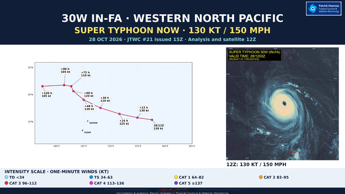
SUPER TYPHOON 30W (IN-FA) — PL1: ANNULAR CORE UNDER SOME MID-LEVEL STRESS
2026 OCT 28 1500 UTC | JTWC warning #21 | Analysis 1200 UTC
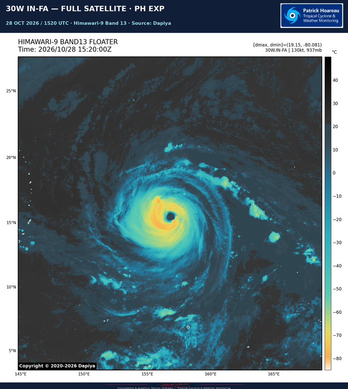
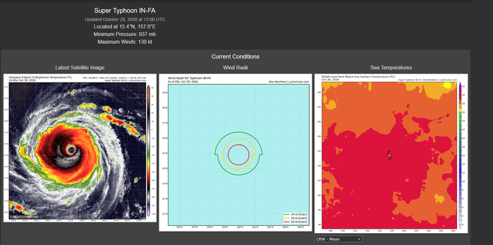
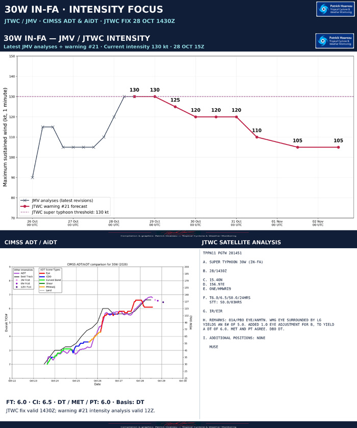
IN-FA remains a super typhoon at 130 kt (150 mph), US category 4, centred near 15.4°N, 157.6°E. It is moving west-northwestward at 13 kt (about 24 km/h), approximately 1,380 km east of Andersen AFB, Guam. The latest JMV records 130 kt at both 06Z and 12Z, following 120 kt at 00Z.
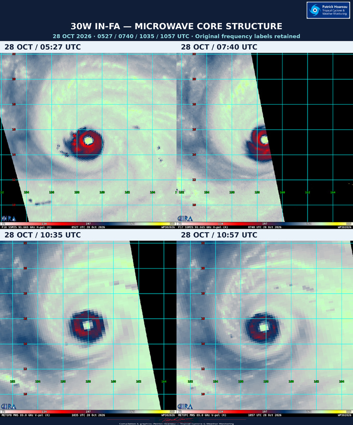
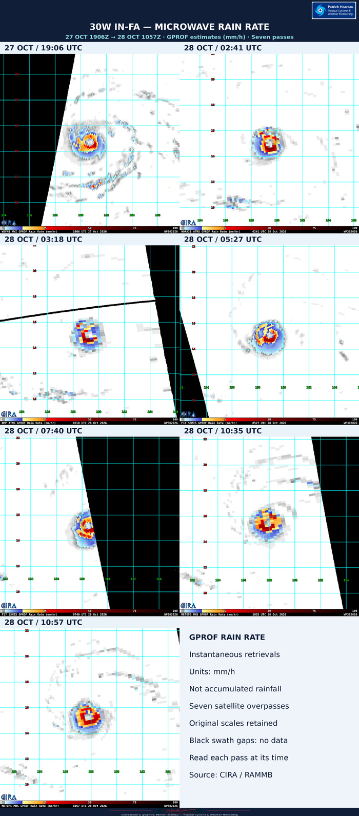
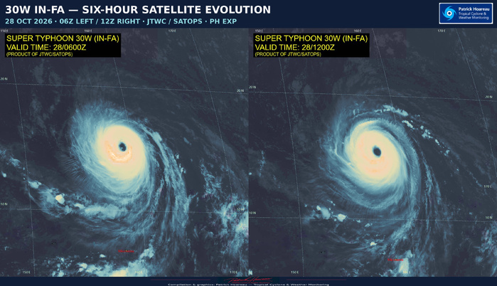
The system retains a compact core of deep convection around an eye approximately 65–74 km wide. However, the cloud canopy has eroded significantly in the northeastern sector during the past six hours. IN-FA still exhibits annular characteristics, with less structural symmetry than at the previous analysis.
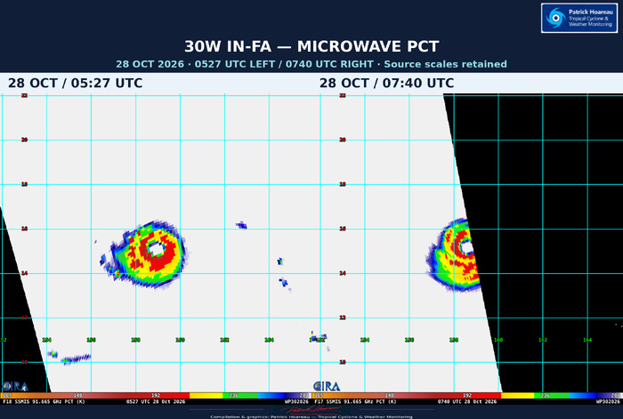
The JTWC cites an 1128Z AWS 89 GHz microwave pass showing a compact convective ring whose northeastern quadrant is shallower and more fragmented. Model-derived soundings indicate that easterly shear in the middle layers is drawing dry air into the upshear-right portion of the circulation. Meanwhile, the 1036Z ASCAT-B pass depicts a nearly symmetrical surface wind field, leading to a slight expansion of the analysed wind radii. These two layers can evolve differently: erosion of the cloud canopy does not mean the surface wind field has already lost its symmetry.
The official forecast maintains 130 kt at +12 h, then eases to 125 kt at +24 h. After +24 h, reduced mid-level shear is expected to let the core regain symmetry and potentially restore its more robust annular appearance. The forecast holds 120 kt from +36 to +60 h, then weakens to 110 kt at +72 h and 105 kt at +96 and +120 h. Warm waters of 29–30°C, low deep-layer shear and strong radial outflow remain supportive despite the present mid-level interference.
IN-FA should continue accelerating through the next 36 hours, potentially reaching a forward speed of about 33 km/h. A developing region of weak steering near Iwo To will then slow the system sharply around +60 h, with a quasi-stationary phase expected from +72 to +96 h. As the mid-latitude trough lifts away and ridging rebuilds from mainland China, the forecast turns west-southwestward towards the end of the five-day period.
Increased shear and upwelling beneath the slow-moving cyclone favour later weakening, partly offset by enhanced poleward outflow. The eventual west-southwestward movement should take the system away from its cold wake and allow intensity to stabilise late in the forecast.
The model track spread is around 185 km at +72 h and 390 km across-track at +120 h. Differences in forward speed become more substantial beyond +96 h, with along-track spread reaching about 510 km at +120 h. Close agreement among ensemble means should therefore not obscure the larger spread of individual members later in the forecast.
The official track follows the multi-model consensus through the forecast period. Unlike the 09Z reasoning, which explicitly favoured the longer intensity maintenance shown by DeepMind, this update follows the CTCX intensity consensus through +72 h before blending towards HWRF. This is the forecast philosophy of warning #21 and should supersede the earlier discussion.
JTWC confidence: track high through +72 h, medium thereafter; intensity medium throughout. The northern Mariana Islands remain a region to monitor as IN-FA approaches; the official track line does not delimit the full extent of possible impacts.
The PL1 combines our PH map, plotted from the exact forecast coordinates in the supplied JTWC/JMV file, with the full 12Z PH EXP satellite image. The accompanying intensity chart separates the latest revised JMV analyses from the future official forecast. The supplied JMV also adjusts the 27 October 18Z longitude from 160.8°E to 160.9°E; its intensity remains 110 kt.
Cheers, Patrick Hoareau.
Tropical Cyclone & Weather Monitoring.



SUPER TYPHOON 30W (IN-FA) — JTWC / SIX ENSEMBLE TRACK COMPARISON
2026 OCT 28 1500 UTC | JTWC warning #21
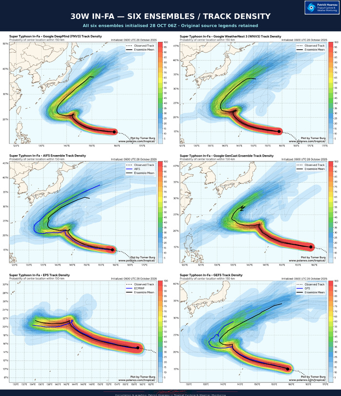
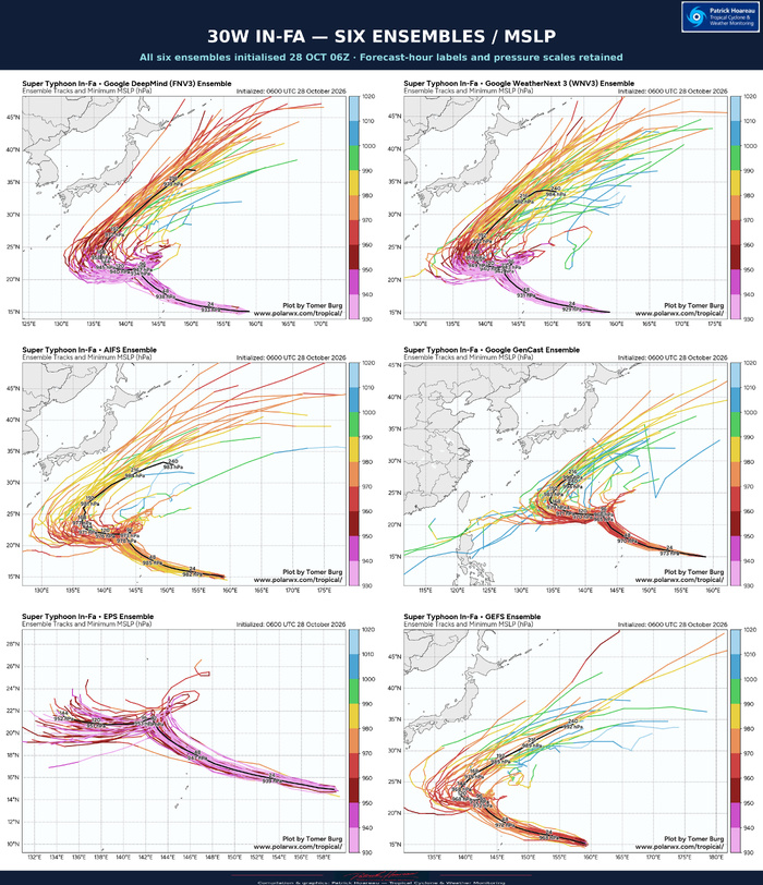
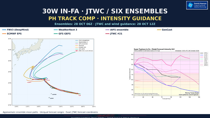
The comparison uses all six supplied ensemble forecasts initialised at 06Z on 28 October: FNV3, WeatherNext 3, AIFS, GenCast, ECMWF EPS and GFS GEFS. They are compared with the JTWC forecast based on the 12Z analysis. This routine six-hour cycle difference is stated on the graphics.
The shared near-term feature is a west-northwestward track becoming increasingly poleward towards the northern Mariana Islands region. The ensemble means also show a marked change of direction around the low-twenties latitudes. Some curves form a tight kink or loop-like feature before extending westward and, in the longer forecasts, eventually northeastward.
The JTWC reasoning describes acceleration through +36 h, sharp deceleration around +60 h, a quasi-stationary phase from +72 to +96 h, and a west-southwestward deflection late in the five-day period. The official forecast follows the multi-model consensus. Agreement between ensemble means remains good, while individual-member dispersion increases after +72 h.
The full displayed mean curves do not all end at the same forecast hour. In particular, the much longer northeastward extensions of some AI ensembles and GEFS must not be compared directly with the shorter EPS or JTWC endpoints. The pressure panels retain the source forecast-hour labels to help distinguish these horizons. An ensemble mean loop can also reflect timing differences among members and is not a literal prediction that the centre will trace that exact shape.
Method: ensemble mean paths on the common PH map are approximately digitised from the black curves in the supplied images. They show the geographical shapes of the means; they are not raw model coordinates or a time-matched forecast verification. JTWC coordinates are taken directly from warning #21 and the supplied JMV file. Source density and pressure charts are included alongside the simplified map to preserve the original spreads, legends and forecast horizons.
The model wind-guidance chart is now updated to the 12Z cycle, matching the initial time of JTWC warning #21. Its OFCL line holds 130 kt through +12 h, eases to 125 kt at +24 h, maintains 120 kt from +36 to +60 h, then declines to 110 kt at +72 h and 105 kt at +96/+120 h.
The intensity spread is substantial. ECMI remains a pronounced high outlier, while AVNI/GFS and HFAI/HAFS-A weaken IN-FA more strongly during the middle part of the forecast. The interpolated DeepMind and WeatherNext guidance generally supports higher intensities than those two dynamical solutions at longer lead times. These individual interpolated model curves must not be confused with the six ensemble mean tracks or the pressure-coloured ensemble members.
As stated in the 15Z JTWC reasoning, the official intensity forecast follows the CTCX consensus through +72 h and subsequently blends towards HWRF. This is the current forecast philosophy; the earlier explicit preference for DeepMind in the 09Z reasoning should not be carried forward unchanged.
The original wind graph, its legend, category shading and forecast range are retained. Mean sea-level pressure colours on the separate ensemble panels are not converted directly to sustained wind categories.
Cheers, Patrick Hoareau.
Tropical Cyclone & Weather Monitoring.