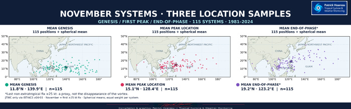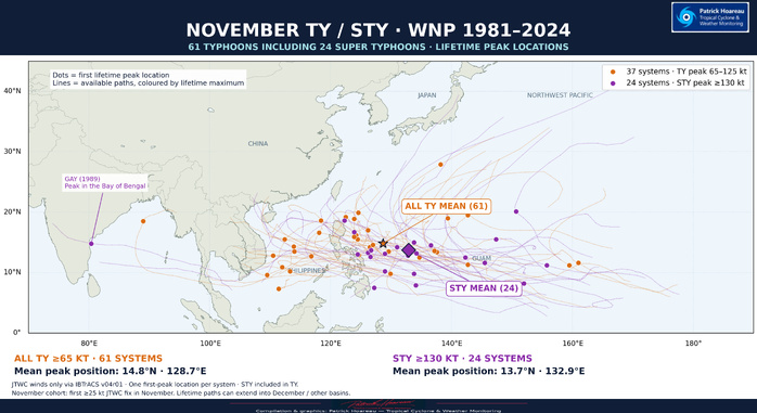


CLICK ON THE MAPS BELOW TO GET THEM ENLARGED

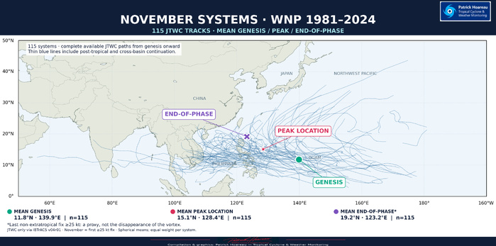
JTWC PH
JTWC FACEBOOK
Joint Typhoon Warning Center
National Hurricane Center
NOVEMBER IN THE WESTERN NORTH PACIFIC — A JTWC CLIMATOLOGICAL PERSPECTIVE
1981–2024 | 44 YEARS
Where do November systems develop, reach their peak and end their tropical phase?
Our new graphics trace 115 systems in the JTWC best-track record, using only JTWC data preserved in NOAA IBTrACS. Selection is based on the first JTWC point at 25 kt occurring in November, rather than the independently verified date of the first operational warning.
Among these systems, 61 reached typhoon intensity of at least 65 kt, including 24 super typhoons at 130 kt or more. That represents averages of 2.61 systems, 1.39 typhoons and 0.55 super typhoons per November. A system's lifetime peak may occur in December.
The first map shows the tracks and three mean positions. The second separates the individual genesis, first-peak and end-of-phase locations. Our additional TY/STY map highlights where the stronger systems reached their lifetime maximum: orange marks the 37 typhoons that stayed below super typhoon strength; purple identifies the 24 super typhoons. Their paths are coloured by lifetime peak, not by intensity at every point along the track.
The tracks show a predominantly westward or west-northwestward pattern, often with only a limited gain in latitude. The Philippines lie at the heart of this November track corridor. Tracks towards Taiwan, China and the Japanese islands are less represented, although some systems still curve northward towards these regions. This geographical pattern is not a calculated probability of impact, and a cyclone’s effects can extend well beyond its centre track.
The mean genesis location for all 115 systems is 11.8N, 139.9E; the mean first-peak position is 15.1N, 128.4E. These averages describe this historical sample, rather than a forecast route or the most likely location of a future cyclone. Each system receives equal weight.
For the end-of-phase map, we use the last non-extratropical fix at or above 25 kt as a consistent reference. It is a proxy, not a confirmed location where the vortex completely disappears. Cross-basin continuations are retained, including GAY (1989), which reached its peak in the Bay of Bengal.
Cheers,
Patrick Hoareau
Tropical Cyclone & Weather Monitoring