

CLICK ON THE IMAGERIES BELOW TO GET THEM ENLARGED

JTWC PH
JTWC FACEBOOK
Joint Typhoon Warning Center
National Hurricane Center
10/13/2026
10/06/2026
09/29/2026
09/22/2026
GTH Outlook Discussion
Last Updated - 10/20/26
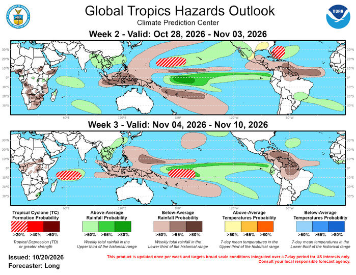
Valid - 10/28/26 - 11/10/26
The low-frequency El Nino background state continues to dominate the convective pattern across the global tropics. In addition, a strengthening positive Indian Ocean Dipole (+IOD) is adding further low-frequency interference with the RMM-based Madden Julian Oscillation (MJO) forecasts. Over the past week, the RMM index showed the MJO slowly propagating eastward across the Western Hemisphere before moving into the Indian Ocean (Phase 2). This is the first time since June the MJO has progressed this far east into the Indian Ocean in RMM-space. While the signal may be amplified by the +IOD in the region, upper-level velocity potential anomalies and objective wave filtering support MJO activity over the Indian Ocean. The upper-level wave-1 pattern has broken down into a wave-2 pattern, with the entrenched El Nino signal over the Maritime Continent and Pacific Ocean, and the MJO signal moving through the Indian Ocean.
Over the next two weeks, dynamical model forecasts continue eastward propagation through the Indian Ocean before stalling the MJO in Phase 3. While the ECMWF keeps the signal in the Indian Ocean during week-3, the GEFS and CFS move the signal back into the Western Hemisphere (Phase 1). The upper-level velocity potential anomalies support continued eastward propagation, showing a noticeable weakening of anomalous convergence over the Maritime Continent during week-3 which suggests the MJO signal is continuing to propagate eastward, interfering with the strong El Nino signal.
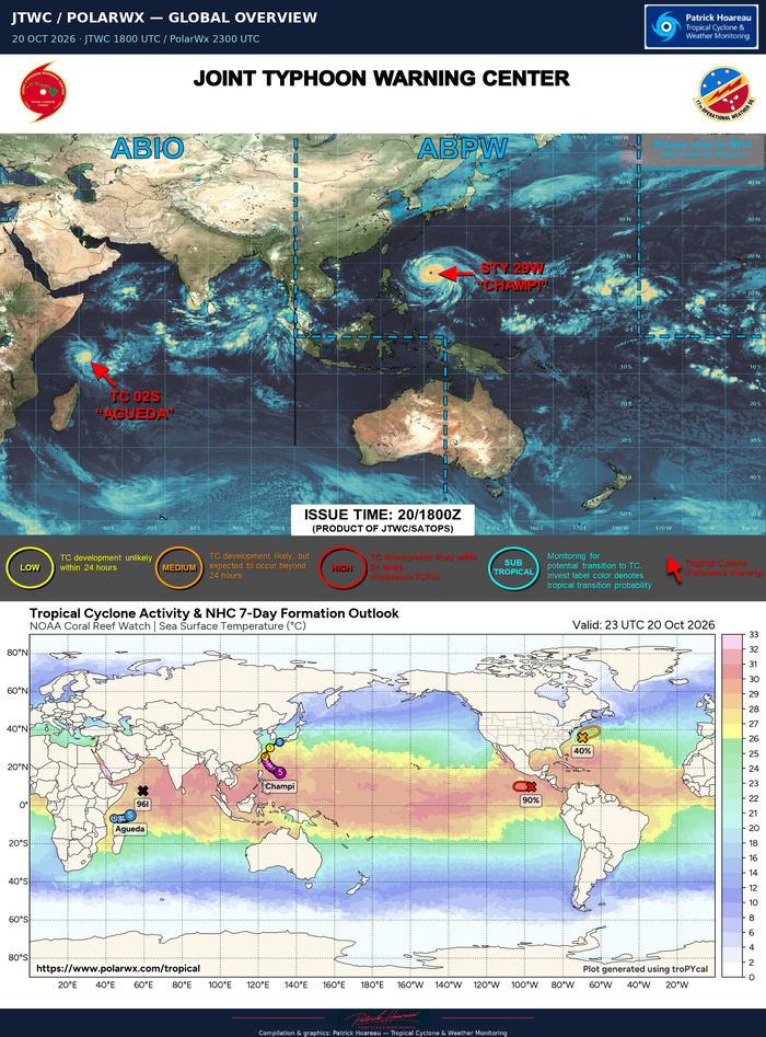
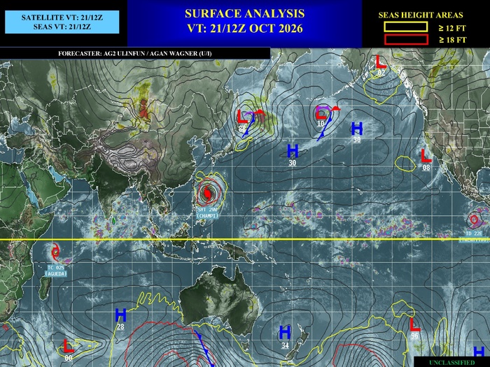
Over the past week, three tropical cyclones (TCs) formed globally, while TC Trudy continued tracking northwest along the coast of Mexico. TC Trudy reached category 3 hurricane strength then weakened slightly before skirting southwestern Mexico and turning slightly westward as it became post-tropical on 10/20. In the western Pacific, TC Champi formed as a tropical depression on 10/14 near 10N/161E. It rapidly intensified into a Super Typhoon before passing just south of Guam and is forecasted to remain a powerful typhoon as it continues to track northwestward towards Taiwan. In the Southern Hemisphere, the tropical season kicked off early, with TC Wati forming on 10/15 in the South Pacific at 8S/164W. TC Wati reached peak winds of 65kts as it tracked southeastward before becoming extratropical on 10/19. On 10/19, TC Agueda formed in the South Indian Ocean to the north of Madagascar. It is forecasted to move westward toward Tanzania.
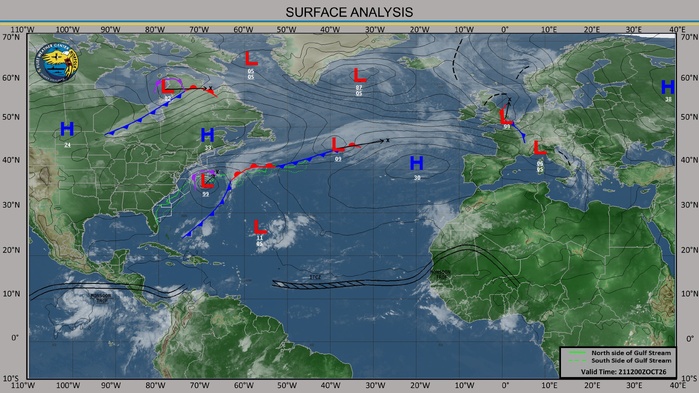
Over the next week, corresponding with the MJO signal over the Indian Ocean, the Joint Typhoon Warning Center (JTWC) is watching two areas in the North Indian Ocean with a 60% probability of formation in the Bay of Bengal and a 10% chance of formation in the Arabian Sea. In the Western Pacific between 160 to 175 deg E, the JTWC is predicting a 70% chance of possible development. In the Western Hemisphere, the National Hurricane Center (NHC) is monitoring a low-pressure system to the far south of Guatemala with a 90% chance of development over the next few days. They are also watching a low-pressure system along a frontal boundary off the eastern coast of the U.S. for possible subtropical development (40% chance). For further updates on active systems and possible Week-1 development, please refer to the JTWC at https://www.metoc.navy.mil/jtwc/jtwc.html and the NHC at https://www.nhc.noaa.gov/.
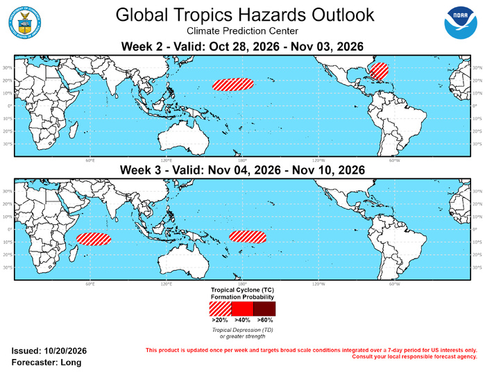
In the Atlantic, additional TC development is possible off the southeast U.S. coast along another frontal passage early in week-2, resulting in a 20-40% chance of formation. Cyclogenesis would likely occur farther south than the system currently being monitored for development over the next few days and is more likely to exhibit tropical characteristics. Model guidance has been trending towards an earlier formation, indicating the possibility that genesis could occur near the end of week-1. In the Eastern Pacific, tropical activity looks to be waning entering November due to weakening westerly wind anomalies and increasing vertical wind shear. During week-3, there are low probabilities (<20%) for some activity to the far southeast of Hawaii where wind shear remains lighter.
In the Western Pacific, conditions remain conducive for further development between 155E to 170W through week-2, supported by strong westerly wind anomalies in the region and dynamical model support. These westerly anomalies are forecasted to shift farther south during week-3, providing favorable conditions in the South Pacific from 170E to 160W. Both areas are highlighted with a 20-40% chance of TC formation. Although it is early for formation in the South Pacific, TC Wati has already formed over the past week, and model guidance supports further genesis in the region. In addition, dynamical models support a 20-40% chance of development in the South Indian Ocean during week-3 as the MJO signal potentially lingers across the basin.

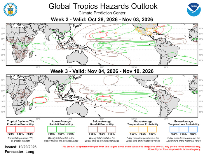
The precipitation outlook for Weeks 2 and 3 is based on the skill weighted consolidated blend of GEFS, CFS, and ECMWF ensemble forecast systems, historical composites during Oct-Dec for MJO phases 1-3, and the low frequency influence associated with El Nino. Below-average rainfall is expected to continue over the Maritime Continent and the Caribbean Sea and also the higher latitudes of the Pacific. Above-normal rainfall is expected across the equatorial Pacific with the ongoing El Nino and portions of the western Indian Ocean with ongoing MJO activity in the region and the strengthening +IOD. Increased chances for above-normal (though non-hazardous) temperatures are expected along portions of the southeastern United States, southern Florida, and portions of Hawaii during Week-2. For hazardous weather conditions in your area during the next two weeks, please refer to your local NWS office, the Medium Range Hazards Forecast from the Weather Prediction Center (WPC), and the CPC Week-2 Hazards Outlook. Forecasts over Africa are made in consultation with the International Desk at CPC and can represent local-scale conditions in addition to global-scale variability.