

CLICK ON THE IMAGERIES BELOW TO GET THEM ENLARGED

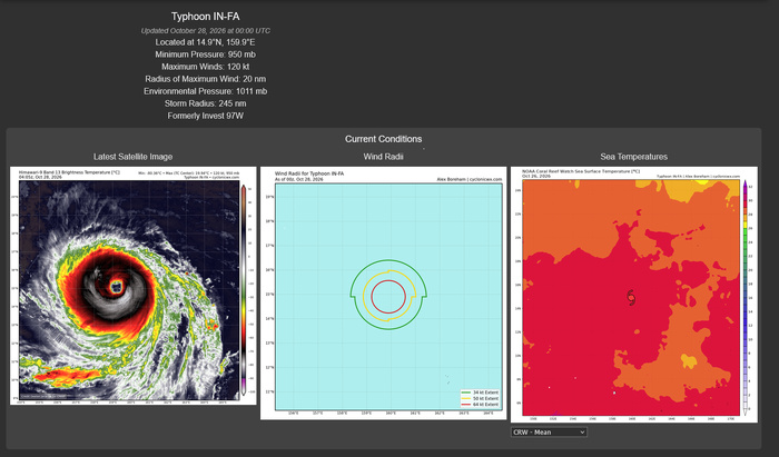

30W (IN-FA) — PL1: FORECAST AND SATELLITE STRUCTURE
2026 OCT 28 0300 UTC | JTWC warning #19 | Analysis 00Z
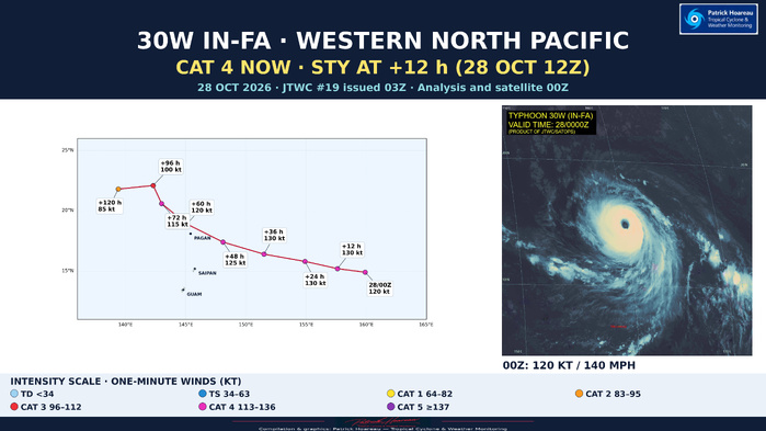
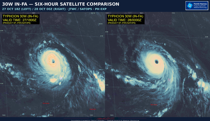
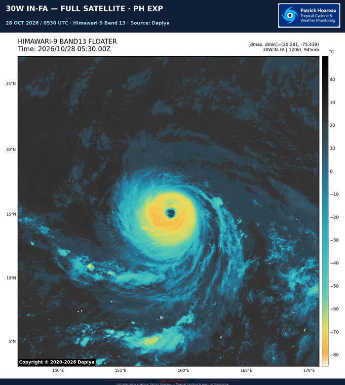
At 14.9°N, 159.9°E, IN-FA is approximately 1,515 km east of Saipan, moving west-northwestward at 9 kt (about 17 km/h). The 120 kt (140 mph) analysis places it in US category 4.
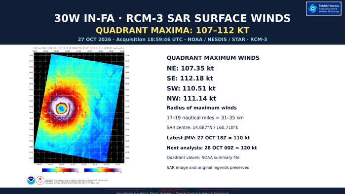
The JTWC describes an approximately 74 km-wide eye that has almost completely cleared, surrounded by a highly symmetrical central dense overcast. The 27 October 18:59:46 UTC RCM-3 SAR pass resolves a compact, remarkably symmetrical surface wind field around a clearly defined eye. Its accompanying NOAA summary gives quadrant maxima of 107.35 kt (NE), 112.18 kt (SE), 110.51 kt (SW) and 111.14 kt (NW), with the radius of maximum winds at 31–35 km. This pass is close in time to the latest JMV 18Z analysis of 110 kt; it precedes the 00Z analysis of 120 kt by approximately five hours.
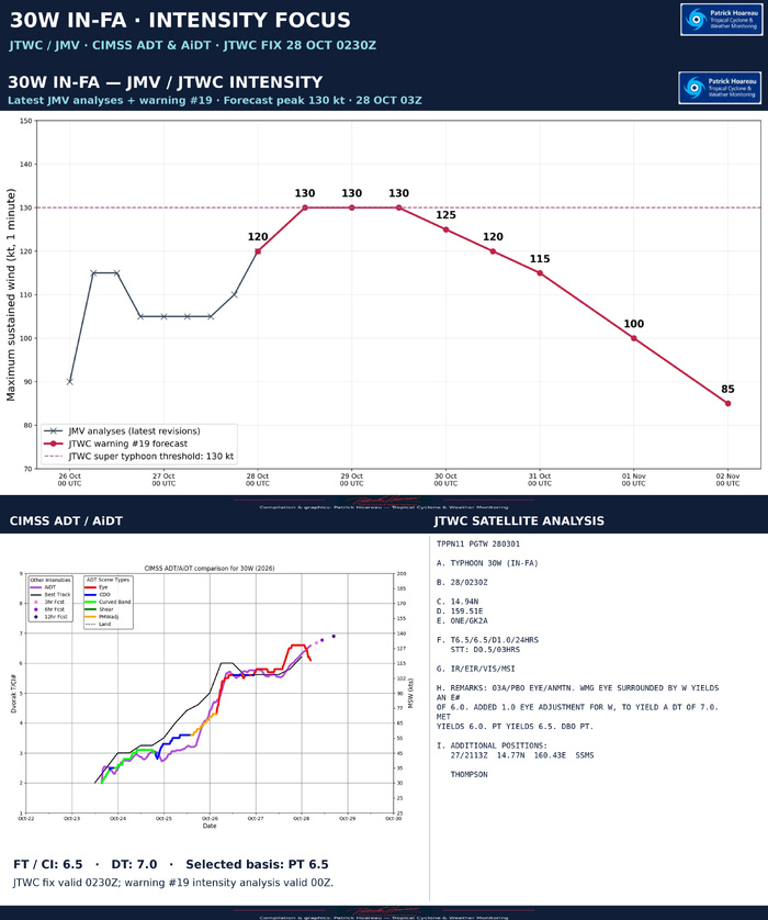
Warm waters of 29–30°C, moderate radial outflow and vertical wind shear of 10–15 kt favour further strengthening. The official forecast reaches 130 kt at +12 h and maintains that intensity through +36 h. That is super typhoon intensity under the JTWC convention, while remaining US category 4.
The ridge to the north steers IN-FA west-northwestward and then increasingly poleward through +72 h. After that, a second ridge building from the west creates weak steering. Erratic or quasi-stationary motion is possible and cannot be represented explicitly by the simple forecast line. Track confidence is high to +72 h and low from +72 to +120 h.
The northern Mariana Islands merit close monitoring. The track should not be read as a guarantee that adverse weather is restricted to the centre line; the official charts also show wind radii and forecast uncertainty.
The large eye and potential eyewall replacement cycles, explicitly depicted by HAFS-A, could cap intensification and contribute to subsequent weakening. After +96 h, upwelling beneath a slow-moving system is expected to reinforce that decline. Intensity confidence remains medium throughout.
Cheers, Patrick Hoareau.
Tropical Cyclone & Weather Monitoring.




30W (IN-FA) — JTWC / ENSEMBLES: A SHARED NEAR-TERM CORRIDOR, THEN A MORE COMPLEX EVOLUTION
2026 OCT 28 0300 UTC
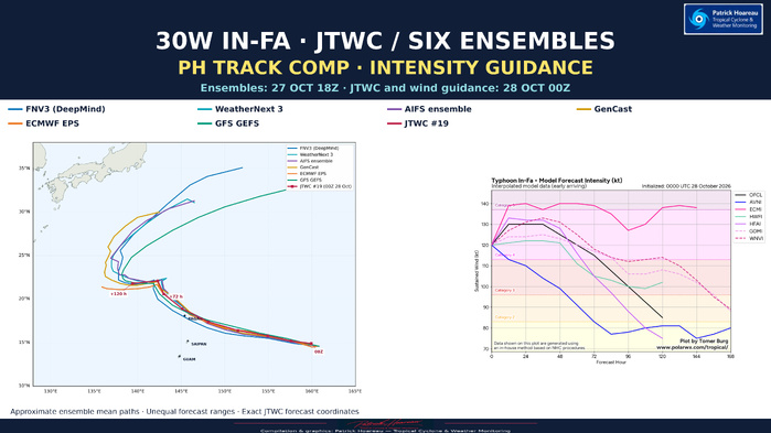
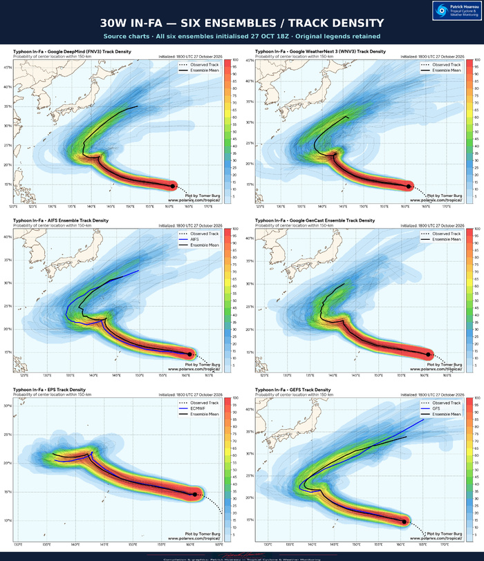
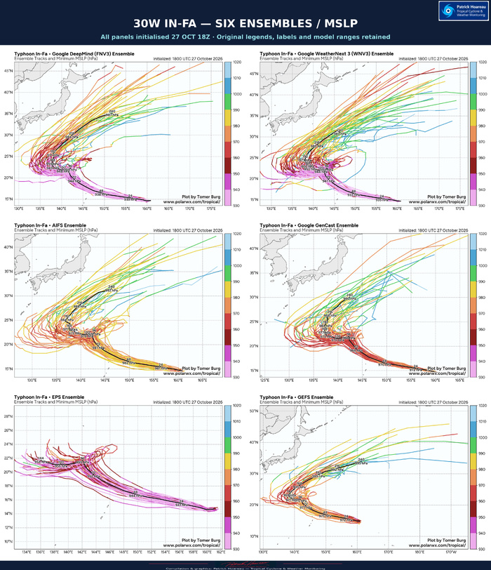
The PH comparison now brings together the JTWC forecast with six supplied ensemble means: Google DeepMind FNV3, WeatherNext 3, AIFS, GenCast, ECMWF EPS and GFS GEFS. The ensembles were initialised at 18Z on 27 October; the JTWC warning #19 analysis and the interpolated model guidance are valid at 00Z on 28 October. This normal six-hour cycle difference is identified on the graphics.
The ensemble means share a west-northwestward corridor from the present location towards the northern Mariana Islands region, then curve more poleward. The more revealing differences emerge later, as the tracks slow, bend or turn westward around the low-twenties latitudes.
The JTWC forecast ends at +120 h with a westward displacement after +96 h. Several ensemble mean paths subsequently turn northeastward, but their displayed forecasts extend for different lengths of time, in some cases well beyond the JTWC five-day horizon. Their endpoints must therefore not be compared as if they represented the same valid time. EPS, in particular, should not be judged against the far longer northeastward extensions of the other supplied plots.
The official reasoning anticipates weak steering beyond +72 h, with erratic or quasi-stationary motion possible. A smooth mean line can conceal the variety of member tracks and the timing differences that produce it. The original density and MSLP panels are included precisely to retain that information alongside the simpler PH overview.
The common-map overlay is a geographical comparison of ensemble mean shapes. Those mean curves have been approximately digitised from the supplied black source lines; they are not raw model coordinates, time-matched verification tracks or a new official forecast. JTWC forecast coordinates are read directly from the supplied warning/JMV file. All six supplied ensembles are included. WeatherNext 3 is initialised at 18Z on 27 October, matching the other five ensemble charts.
For intensity, the current JTWC forecast reaches 130 kt by +12 h and holds that value through +36 h before weakening. The supplied wind-guidance chart shows GFS substantially lower and ECMI substantially higher than the official line. These are individual model forecasts, not ensemble mean pressure estimates. The pressure-coloured member plots cannot be converted directly into one-minute sustained wind categories.
The six pressure panels retain their original forecast-hour labels, central pressure values and colour scales. They complement the track-density plots rather than replacing the official intensity forecast.
Cheers, Patrick Hoareau.
Tropical Cyclone & Weather Monitoring.




30W (IN-FA) — IMPRESSIVE MICROWAVE SIGNATURE
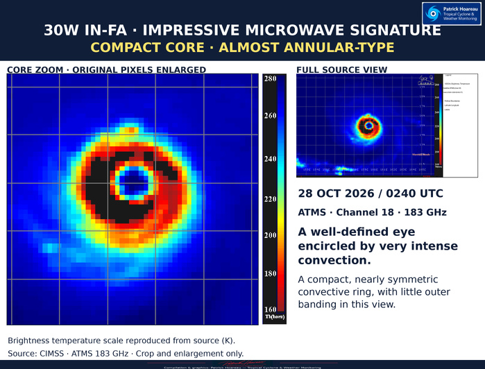
28 OCT 2026 / 0240 UTC
The ATMS 183 GHz image reveals a well-defined eye encircled by very intense convection. The compact, nearly symmetric convective ring and limited outer banding give the core an almost annular-type appearance. The enlarged view retains the original pixels and colour palette.
Cheers, Patrick Hoareau.
Tropical Cyclone & Weather Monitoring.
