

CLICK ON THE IMAGERIES BELOW TO GET THEM ENLARGED


30W IN-FA — BACK TO US CATEGORY 2, THEN ACCELERATING NORTHEASTWARD
03 NOVEMBER 2026 | JTWC WARNING #46 ISSUED 2100 UTC
Official analysis: 1800 UTC | PL1 microwave observation: 2028 UTC
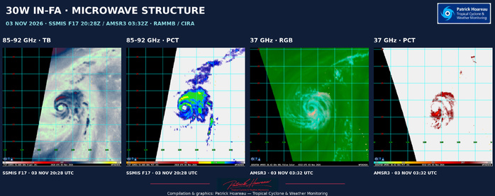
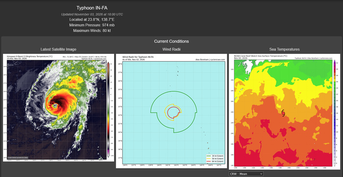
IN-FA has regained US Category 2 intensity. JTWC estimates one-minute sustained winds of 85 kts (about 100 mph), with gusts to 105 kts (about 120 mph), and a central pressure of 970 hPa. At 1800 UTC, the centre was near 23.8°N, 138.7°E, approximately 154 nautical miles west-southwest of Iwo To, moving northward at 6 kts.
A STRONGER RECOVERY THAN THE EARLIER FORECAST
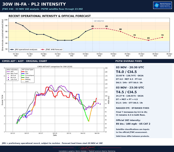
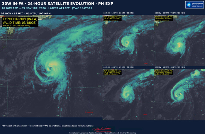
The renewed strengthening anticipated by JTWC has materialised, exceeding the 75 kts forecast in its 0900 UTC warning. The latest operational record rises from 65 kts at 0000 UTC to 70 kts at 0600 UTC, 80 kts at 1200 UTC and 85 kts at 1800 UTC on 3 November. JTWC revised the 1200 UTC estimate to 80 kts after considering scatterometer evidence and the improved convective structure. These operational analyses remain subject to revision.
The warning discussion describes a ragged eye about 30 nautical miles across, encircled by cloud tops of -60 to -65°C. Strong poleward outflow and waters of 27-28°C have supported consolidation despite 20-25 kts of westerly shear and some erosion of the western inner core.
ASCAT-C UHR AND MICROWAVE EVIDENCE
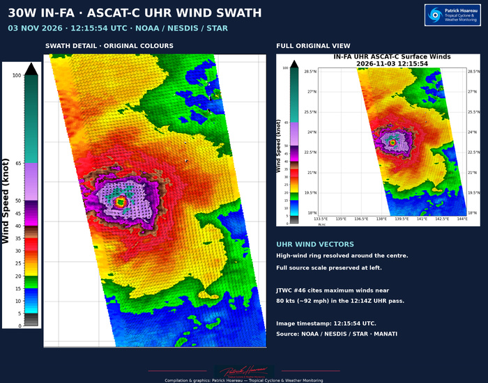
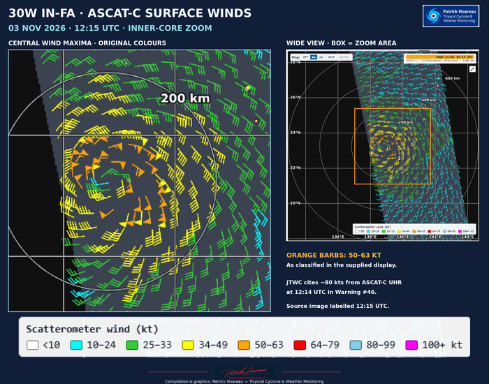
The ASCAT-C UHR pass at 1215 UTC, cited by JTWC, estimated maximum winds near 80 kts and resolves the concentrated high-wind ring around the centre.
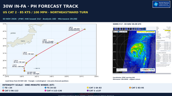
Our PL1 pairs the PH forecast map, plotted from the exact warning #46 coordinates and colour-coded by US wind category, with the later SSMIS F17 microwave observation at 2028 UTC.
24 HOURS OF SATELLITE EVOLUTION
Our five-image PH EXP composite follows IN-FA from 1800 UTC on 2 November to 1800 UTC on 3 November. It shows the renewed organisation of the inner core and the eye becoming more distinct as the operational intensity rises from 65 to 85 kts (about 75 to 100 mph). The latest view is displayed prominently on the left.
NORTHWARD FIRST, THEN A RAPID NORTHEASTWARD RECURVATURE
IN-FA is rounding the western side of the subtropical ridge. An approaching trough should then accelerate it northeastward into the mid-latitude southwesterly flow.
Official forecast, measured from 3 November at 1800 UTC:
- +12 h / 4 November 0600 UTC: 85 kts (about 100 mph).
- +24 h / 4 November 1800 UTC: 80 kts (about 90 mph).
- +36 h / 5 November 0600 UTC: 70 kts (about 80 mph).
- +48 h / 5 November 1800 UTC: 65 kts (about 75 mph), becoming extratropical.
- +60 h / 6 November 0600 UTC: 70 kts (about 80 mph), extratropical.
Increasing shear and progressively cooler waters should weaken the tropical core. Baroclinic support is then forecast to offset part of that decline, with renewed strengthening during the final stage of extratropical transition and an expanding wind field. Completion of the transition does not mean the disappearance of strong winds.
GUIDANCE AND CONFIDENCE
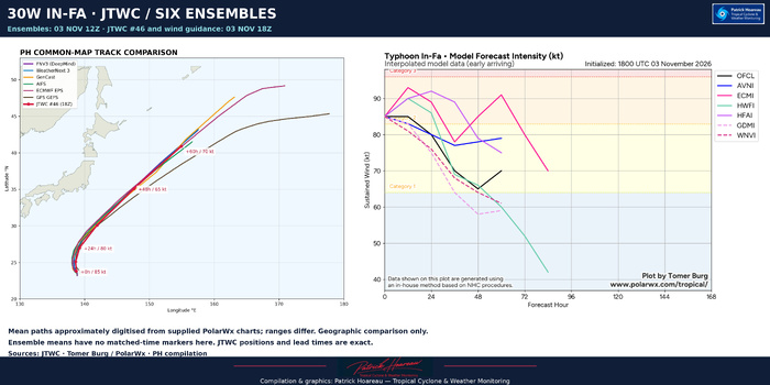
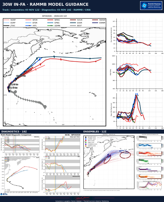
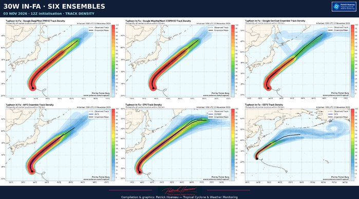
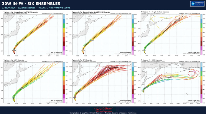
The six supplied ensemble charts are initialised at 1200 UTC, six hours before the official analysis. Their mean paths support the broad northeastward recurvature, with greater divergence farther downstream. Our common-map comparison uses approximately digitised ensemble means and preserves their differing ranges; it is not a comparison at matching forecast hours.
JTWC highlights substantial uncertainty in forward speed, with an along-track model spread of 615 nautical miles at +60 h. It leans towards DeepMind through +48 h and the AI-model mean at +60 h. Track and intensity confidence are both medium.
The later PGTW satellite fixes give T4.0/CI4.5 at 2030 UTC and T4.5/CI4.5 at 2330 UTC. The final T-number increases by 0.5 in three hours while CI remains unchanged; these classifications are inputs to the official assessment, not replacements for it.
Sources: JTWC / PGTW; UW-CIMSS; NOAA/NESDIS/STAR MANATI; RAMMB/CIRA; Tomer Burg / PolarWx.
Cheers,
Pätrick Hoareau
Tropical Cyclone & Weather Monitoring
#InFa #30W #Typhoon #JTWC #NorthwestPacific #TropicalCyclones
03 NOVEMBER 2026 | JTWC WARNING #46 ISSUED 2100 UTC
Official analysis: 1800 UTC | PL1 microwave observation: 2028 UTC
IN-FA has regained US Category 2 intensity. JTWC estimates one-minute sustained winds of 85 kts (about 100 mph), with gusts to 105 kts (about 120 mph), and a central pressure of 970 hPa. At 1800 UTC, the centre was near 23.8°N, 138.7°E, approximately 154 nautical miles west-southwest of Iwo To, moving northward at 6 kts.
A STRONGER RECOVERY THAN THE EARLIER FORECAST
The renewed strengthening anticipated by JTWC has materialised, exceeding the 75 kts forecast in its 0900 UTC warning. The latest operational record rises from 65 kts at 0000 UTC to 70 kts at 0600 UTC, 80 kts at 1200 UTC and 85 kts at 1800 UTC on 3 November. JTWC revised the 1200 UTC estimate to 80 kts after considering scatterometer evidence and the improved convective structure. These operational analyses remain subject to revision.
The warning discussion describes a ragged eye about 30 nautical miles across, encircled by cloud tops of -60 to -65°C. Strong poleward outflow and waters of 27-28°C have supported consolidation despite 20-25 kts of westerly shear and some erosion of the western inner core.
ASCAT-C UHR AND MICROWAVE EVIDENCE
The ASCAT-C UHR pass at 1215 UTC, cited by JTWC, estimated maximum winds near 80 kts and resolves the concentrated high-wind ring around the centre.
Our PL1 pairs the PH forecast map, plotted from the exact warning #46 coordinates and colour-coded by US wind category, with the later SSMIS F17 microwave observation at 2028 UTC.
24 HOURS OF SATELLITE EVOLUTION
Our five-image PH EXP composite follows IN-FA from 1800 UTC on 2 November to 1800 UTC on 3 November. It shows the renewed organisation of the inner core and the eye becoming more distinct as the operational intensity rises from 65 to 85 kts (about 75 to 100 mph). The latest view is displayed prominently on the left.
NORTHWARD FIRST, THEN A RAPID NORTHEASTWARD RECURVATURE
IN-FA is rounding the western side of the subtropical ridge. An approaching trough should then accelerate it northeastward into the mid-latitude southwesterly flow.
Official forecast, measured from 3 November at 1800 UTC:
- +12 h / 4 November 0600 UTC: 85 kts (about 100 mph).
- +24 h / 4 November 1800 UTC: 80 kts (about 90 mph).
- +36 h / 5 November 0600 UTC: 70 kts (about 80 mph).
- +48 h / 5 November 1800 UTC: 65 kts (about 75 mph), becoming extratropical.
- +60 h / 6 November 0600 UTC: 70 kts (about 80 mph), extratropical.
Increasing shear and progressively cooler waters should weaken the tropical core. Baroclinic support is then forecast to offset part of that decline, with renewed strengthening during the final stage of extratropical transition and an expanding wind field. Completion of the transition does not mean the disappearance of strong winds.
GUIDANCE AND CONFIDENCE
The six supplied ensemble charts are initialised at 1200 UTC, six hours before the official analysis. Their mean paths support the broad northeastward recurvature, with greater divergence farther downstream. Our common-map comparison uses approximately digitised ensemble means and preserves their differing ranges; it is not a comparison at matching forecast hours.
JTWC highlights substantial uncertainty in forward speed, with an along-track model spread of 615 nautical miles at +60 h. It leans towards DeepMind through +48 h and the AI-model mean at +60 h. Track and intensity confidence are both medium.
The later PGTW satellite fixes give T4.0/CI4.5 at 2030 UTC and T4.5/CI4.5 at 2330 UTC. The final T-number increases by 0.5 in three hours while CI remains unchanged; these classifications are inputs to the official assessment, not replacements for it.
Sources: JTWC / PGTW; UW-CIMSS; NOAA/NESDIS/STAR MANATI; RAMMB/CIRA; Tomer Burg / PolarWx.
Cheers,
Pätrick Hoareau
Tropical Cyclone & Weather Monitoring
#InFa #30W #Typhoon #JTWC #NorthwestPacific #TropicalCyclones