2021 FEB 24 0245UTC #SOUTHERNHEMISPHERE
INVEST #98S #SOUTHINDIANOCEAN #WESTERNAUSTRALIA
UPDATE
As of 00:00 UTC Feb 24, 2021:
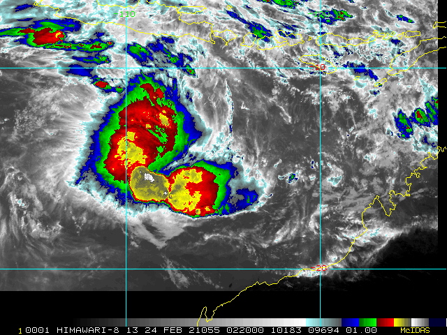
Location: 12.8°S 115.0°E
Maximum Winds: 25 kt
Gusts: 35 kt
Minimum Central Pressure: 1002 mb
LOCATED AT 24/00UTC APPROXIMATELY 1050KM EAST-SOUTHEAST OF CHRISTMAS ISLAND.
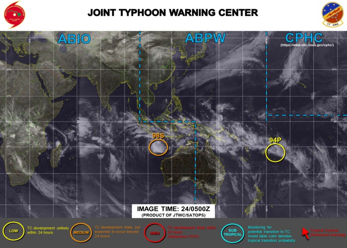
CURRENT POTENTIAL FOR THE NEXT 24HOURS: MEDIUM.
-------------------------------------------------------------------------------------------------------------------
INVEST #94P #SOUTHPACIFICOCEAN
UPDATE
As of 18:00 UTC Feb 23, 2021:
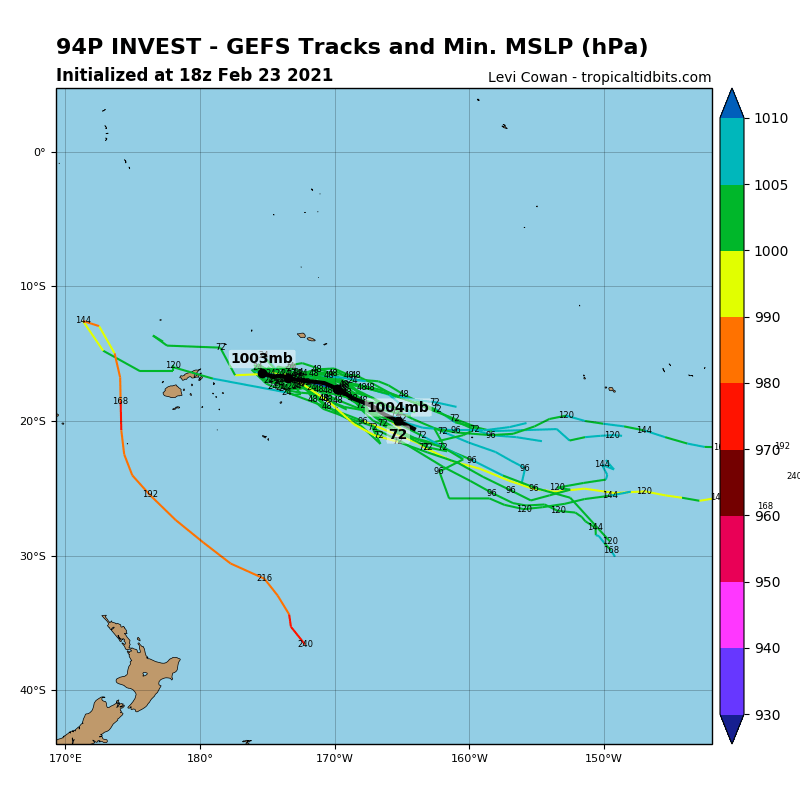
Location: 15.7°S 175.5°W
Maximum Winds: 25 kt
Gusts: 35 kt
Minimum Central Pressure: 1004 mb
LOCATED AT 23/18UTC APPROXIMATELY 15KM SOUTHEAST OF TONGAMAMA, NIUAS ISLANDS.
---------------------------------------------------------------------------------------------------
Cheers,
Patrick Hoareau
Météo974
M974World
Cyclone Class 4
Cheers,PH.
Joint Typhoon Warning Center
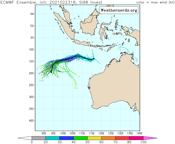
INVEST 98S. RADIAL OUTFLOW, LOW VERTICAL WIND SHEAR (10-15KTS) AND WARM SEA SURFACE TEMPERATURES (29-30C) CREATE FAVORABLE CONDITIONS FOR FURTHER DEVELOPMENT. GLOBAL MODELS INDICATE INVEST 98S WILL TRACK WESTWARD AND INTENSIFY QUICKLY OVER THE NEXT 36-48 HOURS.

INVEST 98S. 24/0220UTC. ANIMATED ENHANCED INFRARED IMAGERY AND A 231900Z GMI 89GHZ MICROWAVE IMAGE DEPICT A CONSOLIDATING LOW LEVEL CIRCULATION CENTER WITH PERSISTENT DEEP CONVECTION.
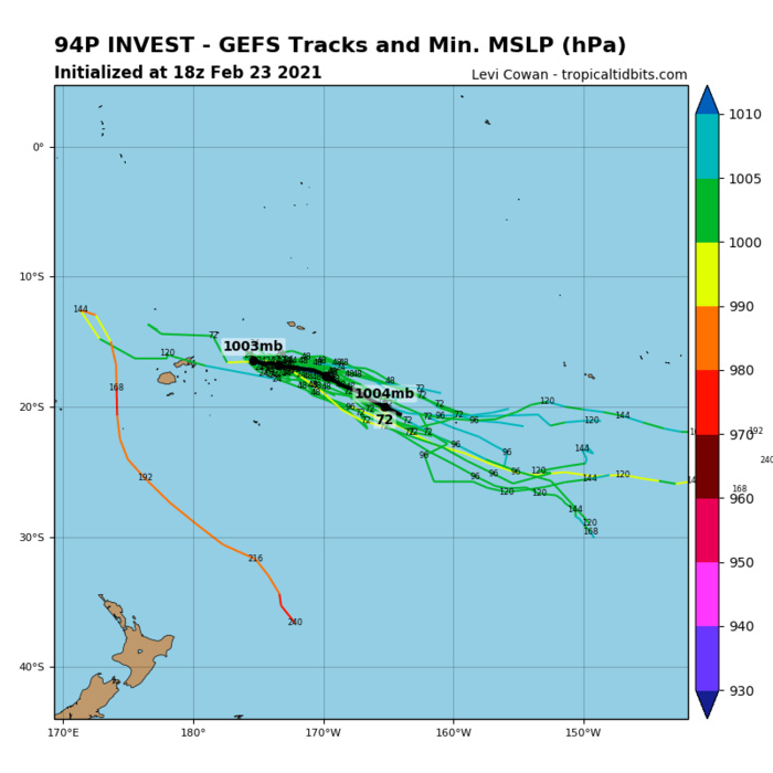
INVEST 94P. GLOBAL MODELS GENERALLY INDICATE THAT INVEST 94P WILL PROPAGATE EAST-SOUTHEASTWARD ALONG THE TROUGH WITH MINIMAL CONSOLIDATION OR STRENGTHENING.

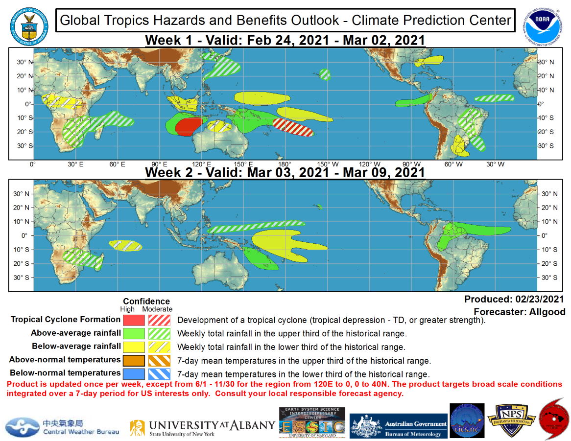
Global Tropics Hazards and Benefits Outlook Discussion Last Updated: 02.23.21 Valid: 02.24.21 - 03.09.21 The amplitude of the RMM-based MJO index has weakened substantially during the past week after strongly projecting onto the West Pacific phase since late January. The strong West Pacific projection was due primarily to a strong Rossby wave that is clearly apparent even in the upper-level velocity potential anomaly field, and as the Rossby wave moved westward to the Maritime Continent, a strong “left turn” in the RMM index ensued. A zonally narrow burst of westerly winds along the equator generated by the Rossby wave over the far West Pacific appears sufficient to have initiated a downwelling oceanic Kelvin wave event, though it is highly uncertain how much this feature will impact the ongoing La Nina conditions across the Pacific. Given the lack of robust MJO conditions, the CPC velocity potential based MJO index exhibited weak amplitude over the past two weeks. Currently, there are three features in the tropical convective field at play: the Rossby wave now over the Maritime Continent, a Kelvin wave entering the western Indian Ocean basin, and an enhanced South Pacific Convergence Zone (SPCZ) that may be due in part to the downwelling oceanic Kelvin wave. Dynamical model MJO index forecasts generally show a brief amplification of the signal over the Maritime Continent due to influence from the Rossby wave, with divergent solutions in Week-2. The GEFS depicts ensemble members in all eight phases of the RMM index at various times over the next two weeks, illustrating the high degree of forecast complexity as the various features in the global tropics interact. The ECMWF also shows considerable uncertainty, but has more clustering on a fast eastward propagation of the signal from the Maritime Continent to the Western Hemisphere over the next two weeks, likely keying in on the Kelvin wave crossing the Indian Ocean. Based on these diverging forecasts, the MJO is not anticipated to play a substantial role in the evolution of the global tropical convective field or the subsequent atmospheric response. La Nina conditions will continue to play a dominant role, but additional westerly wind bursts, perhaps from the oncoming Kelvin wave, may provide additional opportunities for weakening of this low frequency signal. Tropical Storm Dujuan formed from a gyre poleward of the strong equatorial Rossby wave east of the Philippines, attaining a minimum central pressure of 991mb before weakening as it crossed the Philippines. The Rossby wave may help generate new tropical cyclogenesis north of Australia’s Kimberley Coast during Week-1. Dynamical models robustly depict a tropical cyclone forming in this region, with an initial southwesterly track followed by a recurve towards the south or southeast. Several ensemble members of the GEFS and ECMWF depict this potential cyclone strengthening to potential major hurricane intensity on the Saffir-Simpson scale. Interests in Western Australia and the adjacent eastern Indian Ocean should monitor forecasts and advisories from their local government agencies. Elsewhere, tropical cyclogenesis is possible over the Southwest Pacific in association with the enhanced SPCZ. The Joint Typhoon Warning Center is monitoring two areas within this region for potential development. During Week-2, tropical cyclogenesis is possible over the northwestern Pacific, south-central Indian Ocean, and the Coral Sea, but potential is too low currently to depict hazards on the outlook. Forecasts for above- and below-median precipitation are based on a consensus of dynamical model forecasts, potential tropical cyclone activity, and an analysis of the ongoing tropical convective modes. For hazardous weather concerns during the upcoming two weeks across the U.S. please refer to your local NWS Forecast Office, the Weather Prediction Center's Medium Range Hazards Forecast, and CPC's Week-2 U.S. Hazards Outlook. Forecasts over Africa are made in consultation with the International Desk at CPC and can represent local-scale conditions in addition to global-scale variability. NOAA.
