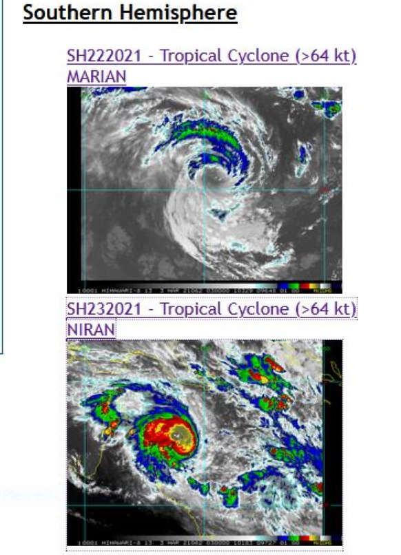
2021 MAR 03 03UTC #SOUTHERNHEMISPHERE
TC #23P #SOUTHPACIFICOCEAN #CORALSEA
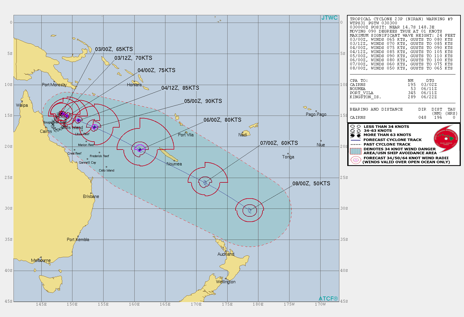
WARNING 9
As of 00:00 UTC Mar 03, 2021:
Location: 14.7°S 148.3°E
Maximum Winds: 65 kt ( 120km/h)
Gusts: 80 kt ( 150km/h)
Minimum Central Pressure: 974mb
INTENSIFYING
CATEGORY US: 1
LOCATED AT 03/00UTC APPROXIMATELY 360 KM NORTHEAST OF CAIRNS, AUSTRALIA, HAS TRACKED EASTWARD AT 02 KM/H
OVER THE PAST SIX HOURS.
Satellite bulletins are to be found in the comments of this post on JTWC BIS
----------------------------------------------------------------------------------------------------------------------
TC #22S #MARIAN #SOUTHINDIANOCEAN
WARNING 11
As of 00:00 UTC Mar 03, 2021:
Location: 18.9°S 90.9°E
Maximum Winds: 80 kt (150km/h)
Gusts: 100 kt ( 185km/h)
Minimum Central Pressure: 969 mb
CATEGORY US : 1
WEAKENING
LOCATED AT 03/00UTC APPROXIMATELY 980 KM SOUTHWEST OF COCOS ISLANDS, AUSTRALIA, HAS TRACKED EAST-
SOUTHEASTWARD AT 07 KM/H OVER THE PAST SIX HOURS.
Satellite bulletins are to be found in the comments of this post on JTWC BIS
Cheers,
Patrick Hoareau
Météo974
M974World
Cyclone Class 4
Cheers,PH.
Joint Typhoon Warning Center

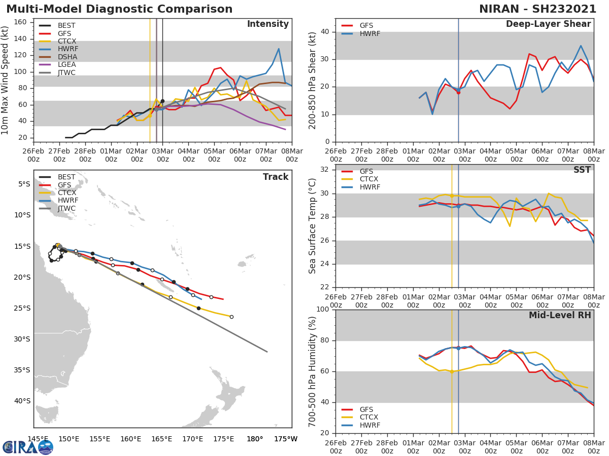
23P(NIRAN). WARNING 9 ISSUED AT 03/03UTC. THE ENVIRONMENT REMAINS OVERALL MARGINALLY FAVORABLE WITH MODERATE (15-20KT) VERTICAL WIND SHEAR, VERY WARM (29-30C) SSTS, AND FAIR RADIAL OUTFLOW ALOFT. TC 23P REMAINS QUASI-STATIONARY AND DRIFTING SLOWLY TO THE EAST-SOUTHEAST AS IT REMAINS IN A COMPLEX STEERING ENVIRONMENT BETWEEN THE NEAR EQUATORIAL RIDGE (NER) TO THE NORTHEAST AND THE SUBTROPICAL RIDGE TO THE WEST OVER AUSTRALIA. ONCE THE NER BECOMES THE DOMINANT STEERING MECHANISM AND NUDGES THE SYSTEM OUT OF THE AREA IN THE NEXT 12 HOURS EXPECT THE SYSTEM TO EJECT TO THE SOUTHEAST. THE SYSTEM IS DUE TO MOVE RAPIDLY TO THE SOUTHEAST AND PASS SOUTH OF NEW CALEDONIA BETWEEN 72H AND 96H. THE ENVIRONMENT WILL BECOME MORE FAVORABLE IN THE NEXT 24 HOURS WITH AN INCREASE OF POLEWARD OUTFLOW AND PROMOTE AN INCREASE IN INTENSIFICATION TO A PEAK OF 90KNOTS/US CATEGORY 2 BY 48H. AFTERWARD, INCREASING WIND SHEAR AND COOLING SEAS WILL BEGIN TO ERODE THE CYCLONE DOWN TO 50KNOTS BY 120H. NEAR 96H THE SYSTEM WILL ENTER THE BAROCLINIC ZONE AND BEGIN EXTRA-TROPICAL TRANSITION AND COMPLETE TRANSITION BY 120H.

23P(NIRAN). NUMERICAL MODELS ARE IN GENERAL AGREEMENT WITH THE TRACK FORECAST WITH SIGNIFICANT VARIATIONS IN ALONG TRACK SPEED IN THE NEAR-TERM AS NIRAN BEGINS TO SLOWLY PROPAGATE TO THE SOUTHEAST. THE ALONG TRACK / CROSS TRACK SPREAD IS NOW LESS THAN 370KM BY 48H, HOWEVER, BY 120H ALONG TRACK / CROSS TRACK SPREAD INCREASES TO WELL OVER 2,400KM, LENDING LOW CONFIDENCE IN THE JTWC TRACK FORECAST THAT IS LAID CLOSE TO THE MODEL CONSENSUS.
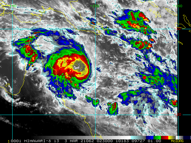
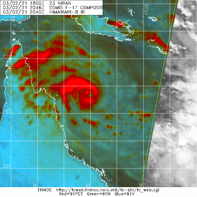
23P(NIRAN). 03/0230UTC. ANIMATED MULTISPECTRAL SATELLITE IMAGERY (MSI) SHOWS CENTRAL DENSE OVERCAST CONTINUING TO DEEPEN AND EXPAND IN THE CORAL SEA.

23P(NIRAN). THE INITIAL POSITION WAS ASSESSED WITH HIGH CONFIDENCE USING A 022046UTC SSMIS 37GHZ AND 91GHZ PASS THAT INDICATES A MICROWAVE EYE BEGINNING TO FORM.

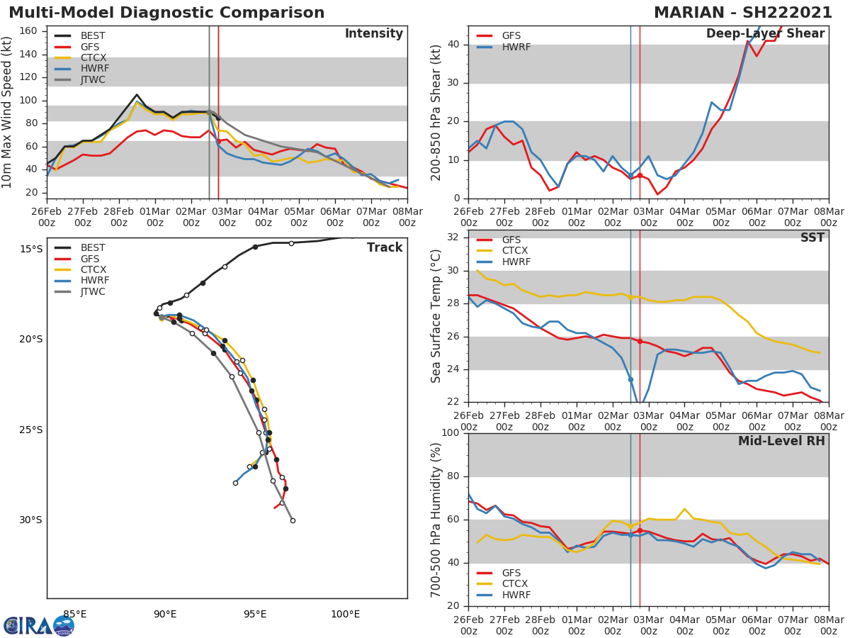
22S(MARIAN). WARNING 11 ISSUED AT 03/03UTC. THE SYSTEM EXISTS IN AN INCREASINGLY HOSTILE ENVIRONMENT WITH HIGH (25- 30KTS) VERTICAL WIND SHEAR AND WEAK RADIAL OUTFLOW, ALONG WITH SEA SURFACE TEMPERATURES NEAR 26C WHICH ARE COOLING AS THE SYSTEM DRIFTS FURTHER TO THE SOUTH-SOUTHEAST. TC 22S IS IN A WEAK STEERING ENVIRONMENT AND REMAINS QUASI-STATIONARY, SLOWLY DRIFTING SOUTH-SOUTHEAST AS A COMPETING NEAR EQUATORIAL RIDGE (NER) TO THE NORTH-NORTHEAST AND A SUBTROPICAL RIDGE (STR) TO THE SOUTH STRUGGLE TO STEER THE SYSTEM FROM ITS CURRENT POSITION. THE STR TO THE SOUTH IS EXPECTED TO WEAKEN WITHIN THE NEXT 12 TO 24 HOURS AS A SECONDARY STR BUILDS IN FROM THE EAST AND ASSUMES THE STEERING AND EVENTUALLY DRIVES THE CYCLONE SOUTH-SOUTHEASTWARD. THE ENVIRONMENT WILL CONTINUE TO DETERIORATE FOR TC 22S AS IT MOVES TO THE SOUTH WITH INCREASING VERTICAL WIND SHEAR AND COOLING SEAS, LEADING TO FURTHER WEAKENING AND EVENTUAL DISSIPATION BY 96H.

22S(MARIAN). NUMERICAL MODELS ARE IN A TIGHT AGREEMENT WITH ONLY A 120KM SPREAD AT 48H AND DIVERGING TO A CROSS- TRACK SPREAD OF 350KM BY 72H, WHEREBY IT BEGINS TO UNDERGO EXTRATROPICAL TRANSITION PHASE IN THE PREVAILING WESTERLIES. EXPECT FULL EXTRATROPICAL TRANSITION TO BE COMPLETE BY 96H, LENDING TO MODERATE CONFIDENCE IN THE JTWC TRACK FORECAST.
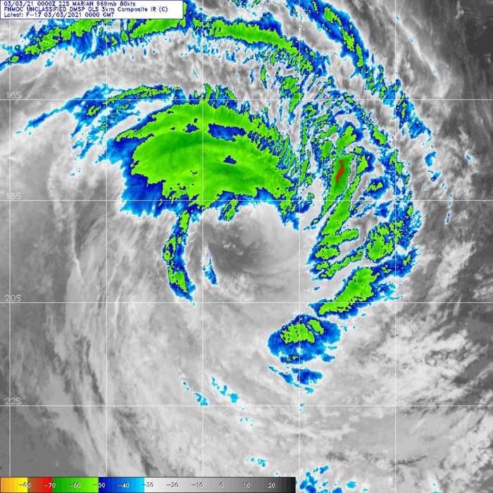
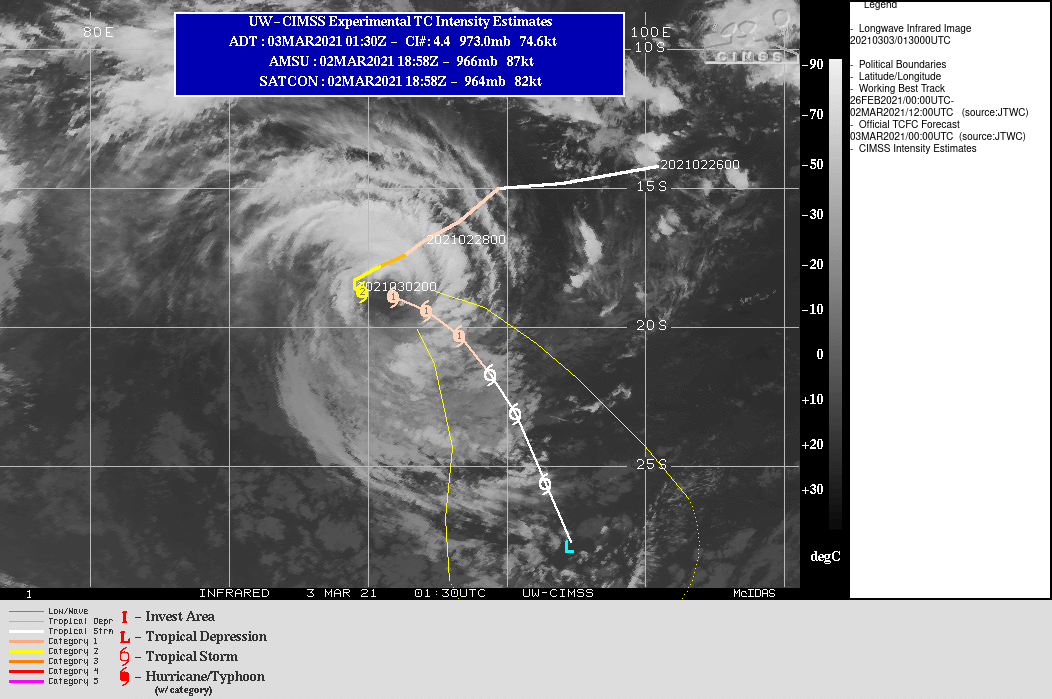
22S(MARIAN). 03/00UTC. DMSP. ANIMATED MULTISPECTRAL SATELLITE IMAGERY AND ENHANCED INFRARED SATELLITE IMAGERY INDICATE THE SYSTEM IS BEGINNING TO WEAKEN AS THE MAIN CONVECTIVE CLOUD TOPS ARE WARMING AND THE EYEWALL IS ERODING AND BECOMING MORE RAGGED.
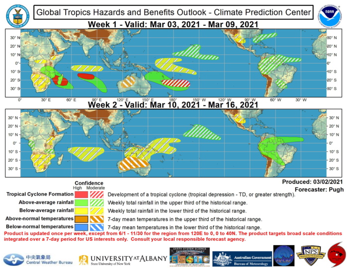
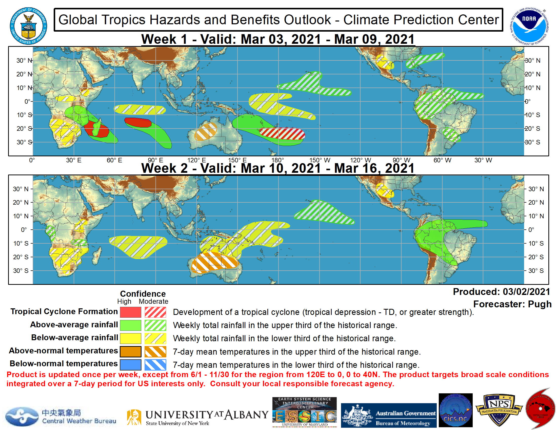
NOAA. ISSUED AT 02/1830UTC. Global Tropics Hazards and Benefits Outlook Discussion Last Updated: 03.02.21 Valid: 03.03.21 - 03.16.21 Recent observations depict a more coherent MJO, with 200-hPa velocity potential anomalies exhibiting a Wave-1 pattern featuring the most anomalous upper-level divergence (convergence) centered over the West Pacific (Atlantic and Africa). The GEFS and ECMWF models are in good agreement that this MJO propagates eastward from the West Pacific to the Western Hemisphere during early to mid-March. Although there is spread among their ensemble members with the MJO amplitude, forecast confidence is higher than in previous weeks that the MJO influences global tropical rainfall along with tropical cyclone development during weeks 1 and 2. Therefore, MJO precipitation composites for phases 7, 8, and 1 were used in drafting this week�s outlook. In addition to the MJO, the ongoing La Nina is also likely to remain a contributor to anomalous tropical rainfall during March. A couple of tropical cyclones (TCs) developed during late February. Tropical Cyclone Marian, which initially formed to the south of Java, tracked westward and strengthened over the South Indian Ocean. As of 12Z March 2, Marian has sustained winds of 90 knots and is located at 18.7S/89.8E and is forecast to gradually weaken later in week-1 as it tracks poleward. Tropical Cyclone Niran has remained nearly stationary to the east of Cairns, Australia. The Joint Typhoon Warning Center calls for Niran to begin accelerating southeastward and could track over or near New Caledonia on March 5 or 6. During week-1, multiple TCs are forecast to develop across parts of the South Indian Ocean and South Pacific. A weak area of low pressure is currently located over the Mozambique Channel, while another surface low is located to the east of Madagascar. Based on good model continuity and agreement, high confidence exists that both of these areas of low pressure become TCs from March 3-9. Meanwhile, the enhanced phase of the MJO and model guidance also support at least a moderate confidence of TC development over the South Pacific during week-1. Following this continued active period through early March, a less favorable large-scale environment is expected for TC development during week-2, as anomalous upper-level convergence is expected to overspread the Indian Ocean, Australia, and the South Pacific. Favored areas of above and below median precipitation are based on: predicted tracks of TCs, a model consensus, MJO precipitation composites (phases 7, 8, and 1) and typical influences from La Nina. Much of the above median precipitation (week-1) across the Indian Ocean and South Pacific is related to either ongoing TCs and/or the additional development of TCs. An overall drying trend is anticipated across the Indian Ocean, Australia, and Southwest Pacific during week-2. Parts of South America are likely to see a wetter pattern during the next two weeks, with an increased risk of heavy rainfall and flooding, especially for Ecuador, Peru, and southern Colombia. Following near to below normal temperatures during late February, above normal temperatures are likely for Western Australia and the Northern Territory of Australia during early March with an expansion of these above normal temperatures forecast across much of Australia by week-2. During week-1, a suppressed mid-latitude low pressure system interacting with an enhanced moisture feed from the subtropics favors above median precipitation from the Florida Peninsula northeast to Bermuda. Consistent with ongoing La Nina conditions, below median precipitation is favored for parts of the southwestern United States and northern Mexico during weeks 1 and 2. For hazardous weather concerns during the upcoming two weeks across the U.S. please refer to your local NWS Forecast Office, the Weather Prediction Center's Medium Range Hazards Forecast, and CPC's Week-2 U.S. Hazards Outlook. Forecasts over Africa are made in consultation with the International Desk at CPC and can represent local-scale conditions in addition to global-scale variability.

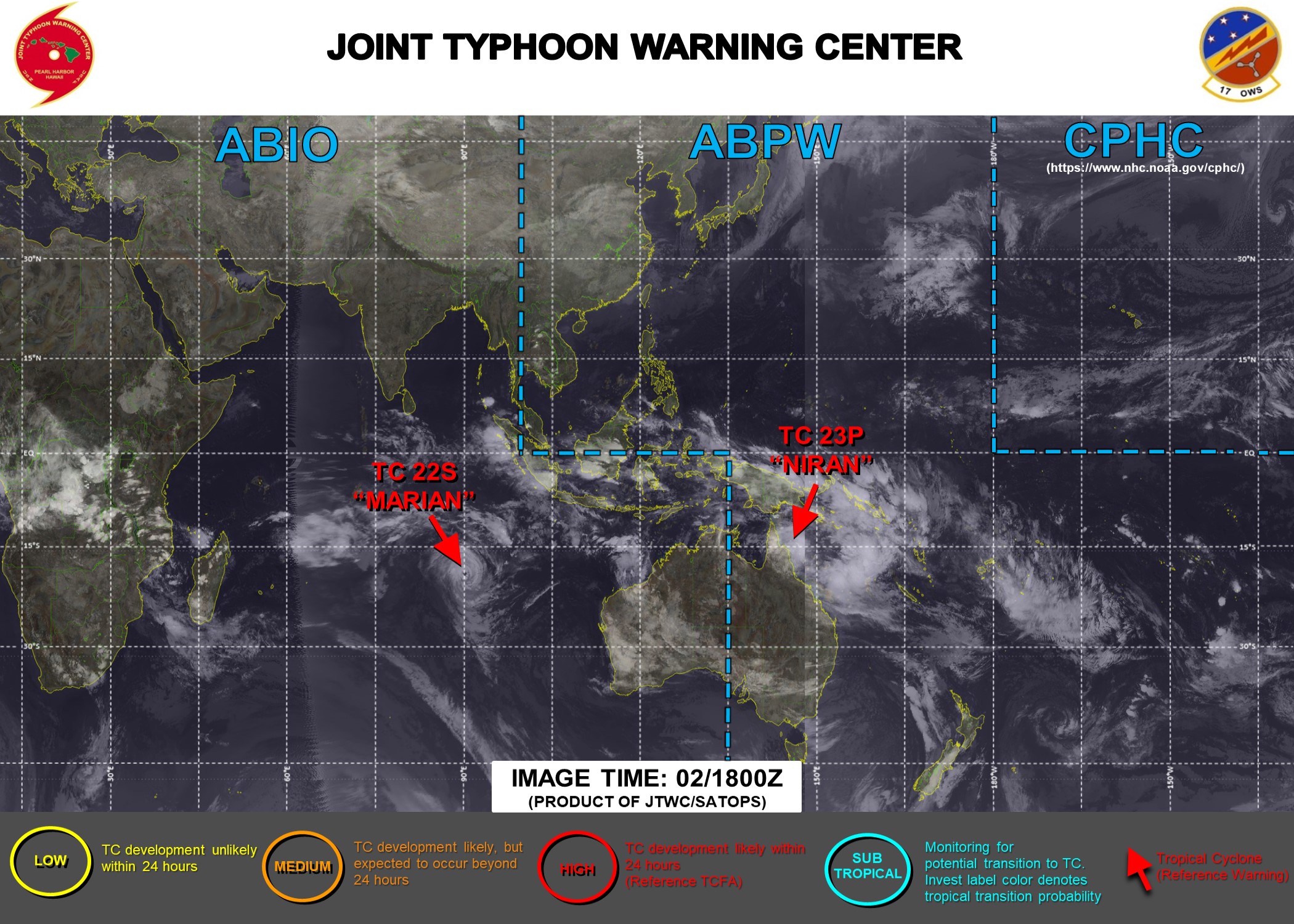
03/03UTC. JTWC IS ISSUING 3HOURLY WARNING ON TC 23P(NIRAN) AND 12HOURLY WARNINGS ON TC 22S(MARIAN). 3 HOURLY SATELLITE BULLETINS ARE ISSUED FOR BOTH SYSTEMS.

03/0245UTC. TC 23P(NIRAN) AND TC 22S(MARIAN) ARE BOTH ANALYZED AT US/CATEGORY 1 BUT 23P IS INTENSIFYING WHEREAS 22S IS WEAKENING AFTER HAVING BRIEFLY REACHED CATEGORY 3 BY 28/12UTC.
