

CLICK ON THE IMAGERIES BELOW TO GET THEM ENLARGED


30W IN-FA — A SHADOW OF ITS FORMER SELF
01 November 2026 · JTWC warning #38 issued 2100 UTC
Analysis valid 1800 UTC · Himawari-9 false-colour RGB valid 2150 UTC
Patrick Hoareau — Tropical Cyclone & Weather Monitoring
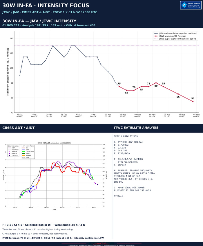
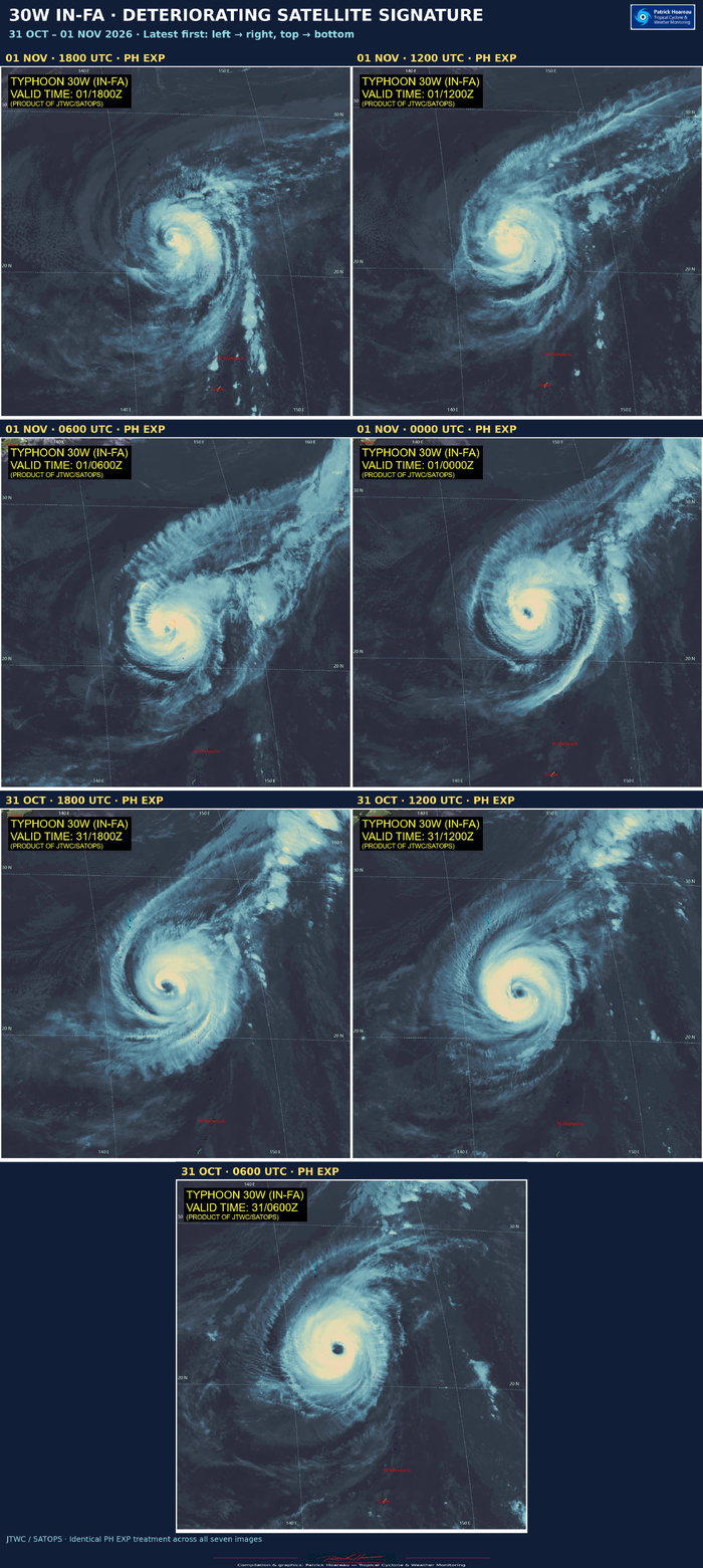
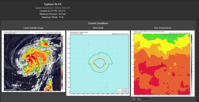
IN-FA’s satellite presentation has continued to deteriorate. JTWC analyses 75 kt (85 mph), Category 1 equivalent on the Saffir–Simpson scale, with gusts of 90 kt (105 mph) and a central pressure of 972 hPa. The centre is at 22.0°N, 143.0°E, approximately 192 nautical miles south-southeast of Iwo To, moving west at 5 kt.
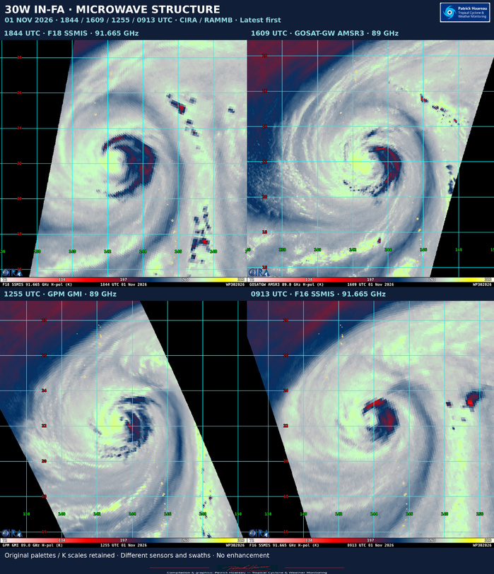
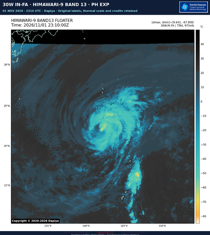
The previously prominent eye is no longer discernible in enhanced infrared imagery; only an intermittent small warm spot, roughly −50°C, remains. The 1550 UTC AMSR3 pass shows erosion of the western convection as dry air enters the circulation and degrades the central dense overcast.
JTWC assesses a marginally unfavourable environment: dry-air entrainment and cool 25–27°C surface waters associated with the storm’s slow motion and upwelling, partly offset by low 5–10 kt vertical shear and strong poleward outflow.
FORECAST
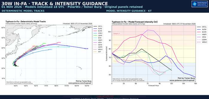
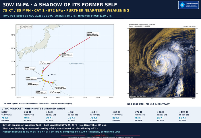
Further weakening to 70 kt (80 mph) is forecast through +24 h while IN-FA remains over its cool wake. A modest recovery to 80 kt (90 mph) is possible at +60 h as forward motion increases and outflow improves. This is followed by renewed weakening as shear increases and extratropical transition develops.
Weak steering between two subtropical ridges initially maintains a slow westward track. A poleward turn is expected by +36 h, followed by acceleration toward the northeast by +72 h. Extratropical transition is expected to begin no later than +96 h and finish no later than +120 h.
FORECAST POINTS — UTC / KT / MPH
+000 h | 01 Nov 18 UTC | 22.0N 143.0E | 75 kt / 85 mph
+012 h | 02 Nov 06 UTC | 22.3N 141.4E | 70 kt / 80 mph
+024 h | 02 Nov 18 UTC | 22.6N 140.2E | 70 kt / 80 mph
+036 h | 03 Nov 06 UTC | 23.0N 139.5E | 75 kt / 85 mph
+048 h | 03 Nov 18 UTC | 23.6N 139.0E | 75 kt / 85 mph
+060 h | 04 Nov 06 UTC | 24.7N 138.8E | 80 kt / 90 mph
+072 h | 04 Nov 18 UTC | 26.4N 139.2E | 75 kt / 85 mph
+096 h | 05 Nov 18 UTC | 32.4N 145.6E | 65 kt / 75 mph | becoming extratropical
+120 h | 06 Nov 18 UTC | 40.9N 159.9E | 55 kt / 65 mph | extratropical
Track confidence is medium through 72 h and low thereafter. Intensity confidence is low throughout: model guidance differs on the extent of any rebound, so it should not be presented as assured.
Significant wave height: 26 ft (approximately 7.9 m), an open-ocean sea-state statistic rather than a maximum individual wave or a coastal surge forecast.
Image treatment: JTWC/SATOPS 1800 UTC PH EXP; Dapiya Himawari-9 2150 UTC false-colour RGB with a 12% contrast increase applied to the image area. Original labels and credits retained. These are different products at different times, not a matched-sensor time comparison.
Sources: supplied JTWC warning #38, prognostic reasoning and track data; PolarWx forecast chart; JTWC/SATOPS and Dapiya imagery.
01 November 2026 · JTWC warning #38 issued 2100 UTC
Analysis valid 1800 UTC · Himawari-9 false-colour RGB valid 2150 UTC
Patrick Hoareau — Tropical Cyclone & Weather Monitoring
IN-FA’s satellite presentation has continued to deteriorate. JTWC analyses 75 kt (85 mph), Category 1 equivalent on the Saffir–Simpson scale, with gusts of 90 kt (105 mph) and a central pressure of 972 hPa. The centre is at 22.0°N, 143.0°E, approximately 192 nautical miles south-southeast of Iwo To, moving west at 5 kt.
The previously prominent eye is no longer discernible in enhanced infrared imagery; only an intermittent small warm spot, roughly −50°C, remains. The 1550 UTC AMSR3 pass shows erosion of the western convection as dry air enters the circulation and degrades the central dense overcast.
JTWC assesses a marginally unfavourable environment: dry-air entrainment and cool 25–27°C surface waters associated with the storm’s slow motion and upwelling, partly offset by low 5–10 kt vertical shear and strong poleward outflow.
FORECAST
Further weakening to 70 kt (80 mph) is forecast through +24 h while IN-FA remains over its cool wake. A modest recovery to 80 kt (90 mph) is possible at +60 h as forward motion increases and outflow improves. This is followed by renewed weakening as shear increases and extratropical transition develops.
Weak steering between two subtropical ridges initially maintains a slow westward track. A poleward turn is expected by +36 h, followed by acceleration toward the northeast by +72 h. Extratropical transition is expected to begin no later than +96 h and finish no later than +120 h.
FORECAST POINTS — UTC / KT / MPH
+000 h | 01 Nov 18 UTC | 22.0N 143.0E | 75 kt / 85 mph
+012 h | 02 Nov 06 UTC | 22.3N 141.4E | 70 kt / 80 mph
+024 h | 02 Nov 18 UTC | 22.6N 140.2E | 70 kt / 80 mph
+036 h | 03 Nov 06 UTC | 23.0N 139.5E | 75 kt / 85 mph
+048 h | 03 Nov 18 UTC | 23.6N 139.0E | 75 kt / 85 mph
+060 h | 04 Nov 06 UTC | 24.7N 138.8E | 80 kt / 90 mph
+072 h | 04 Nov 18 UTC | 26.4N 139.2E | 75 kt / 85 mph
+096 h | 05 Nov 18 UTC | 32.4N 145.6E | 65 kt / 75 mph | becoming extratropical
+120 h | 06 Nov 18 UTC | 40.9N 159.9E | 55 kt / 65 mph | extratropical
Track confidence is medium through 72 h and low thereafter. Intensity confidence is low throughout: model guidance differs on the extent of any rebound, so it should not be presented as assured.
Significant wave height: 26 ft (approximately 7.9 m), an open-ocean sea-state statistic rather than a maximum individual wave or a coastal surge forecast.
Image treatment: JTWC/SATOPS 1800 UTC PH EXP; Dapiya Himawari-9 2150 UTC false-colour RGB with a 12% contrast increase applied to the image area. Original labels and credits retained. These are different products at different times, not a matched-sensor time comparison.
Sources: supplied JTWC warning #38, prognostic reasoning and track data; PolarWx forecast chart; JTWC/SATOPS and Dapiya imagery.