CLICK ON THE IMAGERIES BELOW TO GET THEM ENLARGED
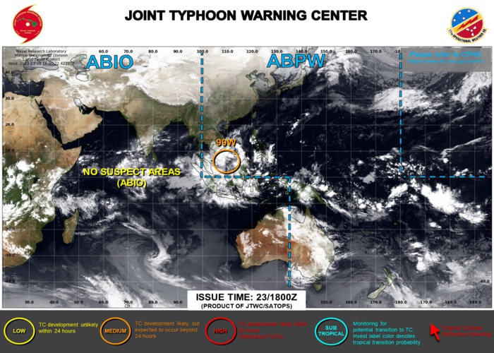
WESTERN NORTH PACIFIC: INVEST 99W.
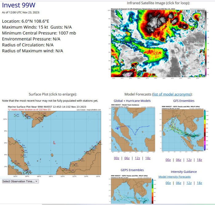
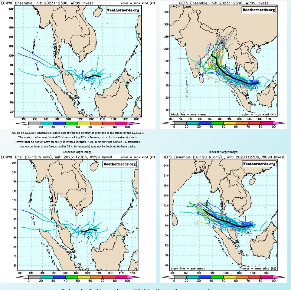
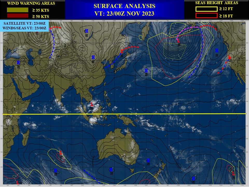
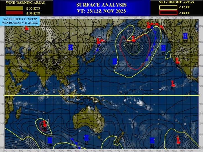
THE AREA OF CONVECTION (INVEST 99W) PREVIOUSLY LOCATED NEAR 6.2N 109.8E IS NOW LOCATED NEAR 6.0N 108.6E, APPROXIMATELY 624 NM EAST OF PHUKET. ANIMATED ENHANCED INFRARED SATELLITE IMAGERY AND A 231033Z SSMIS 91 GHZ MICROWAVE IMAGE DEPICT A BROAD LOW-LEVEL CIRCULATION (LLC) WITH FORMATIVE BANDING IN THE NORTHERN AND SOUTHERN PERIPHERIES. THE CIRCULATION IS LOCATED ADJACENT TO A 20-25 KNOT NORTHEAST SURGE EVENT. ENVIRONMENTAL ANALYSIS INDICATES THAT 99W IS IN A FAVORABLE ENVIRONMENT FOR DEVELOPMENT WITH GOOD OUTFLOW ALOFT, LOW TO MODERATE (15-20 KTS) VERTICAL WIND SHEAR, AND WARM (29-30 C) SEA SURFACE TEMPERATURES. GLOBAL MODELS ARE IN GOOD AGREEMENT THAT 99W WILL TRACK WESTWARD OVER THE NEXT 48 HOURS BUT DISAGREE ON DEVELOPMENT. GFS HAS 99W CONTINUING TO DEEPEN BEFORE CROSSING THE MALAY PENINSULA WHILE ECMWF HAS VERY LITTLE IN TERMS OF INTENSIFICATION. MAXIMUM SUSTAINED SURFACE WINDS ARE ESTIMATED AT 15 TO 20 KNOTS. MINIMUM SEA LEVEL PRESSURE IS ESTIMATED TO BE NEAR 1006 MB. THE POTENTIAL FOR THE DEVELOPMENT OF A SIGNIFICANT TROPICAL CYCLONE WITHIN THE NEXT 24 HOURS IS UPGRADED TO MEDIUM.
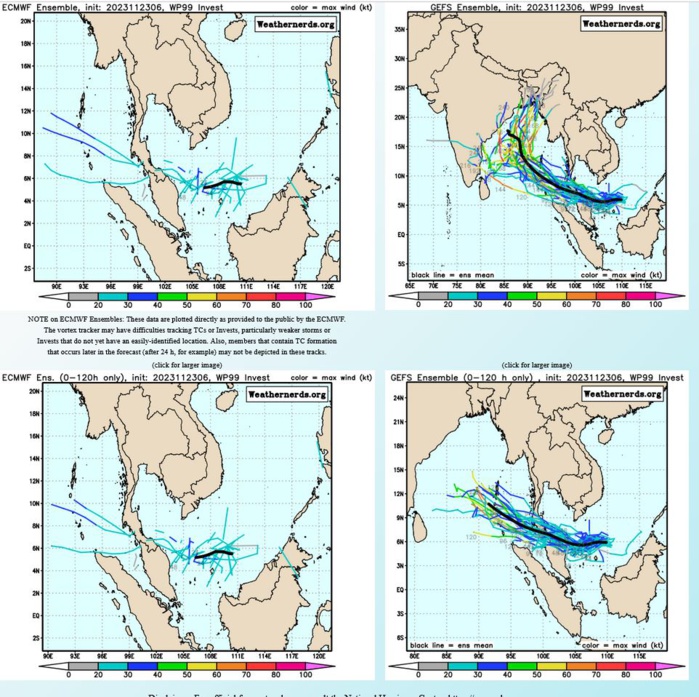
GLOBAL MODELS ARE IN GOOD AGREEMENT THAT 99W WILL TRACK WESTWARD OVER THE NEXT 48 HOURS BUT DISAGREE ON DEVELOPMENT. GFS HAS 99W CONTINUING TO DEEPEN BEFORE CROSSING THE MALAY PENINSULA WHILE ECMWF HAS VERY LITTLE IN TERMS OF INTENSIFICATION.
Tropical Cyclone Only GTH Map
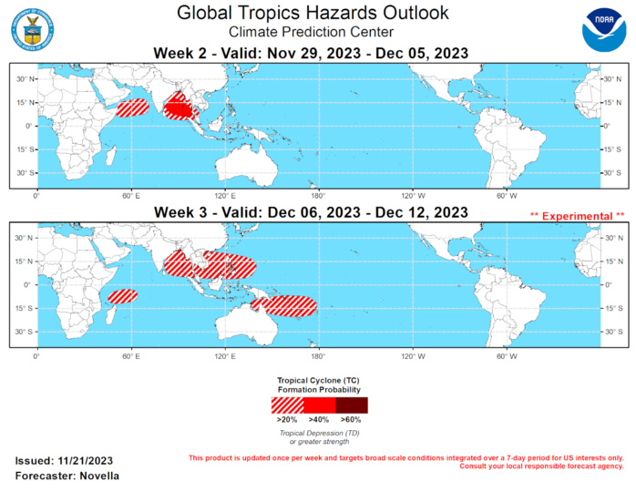
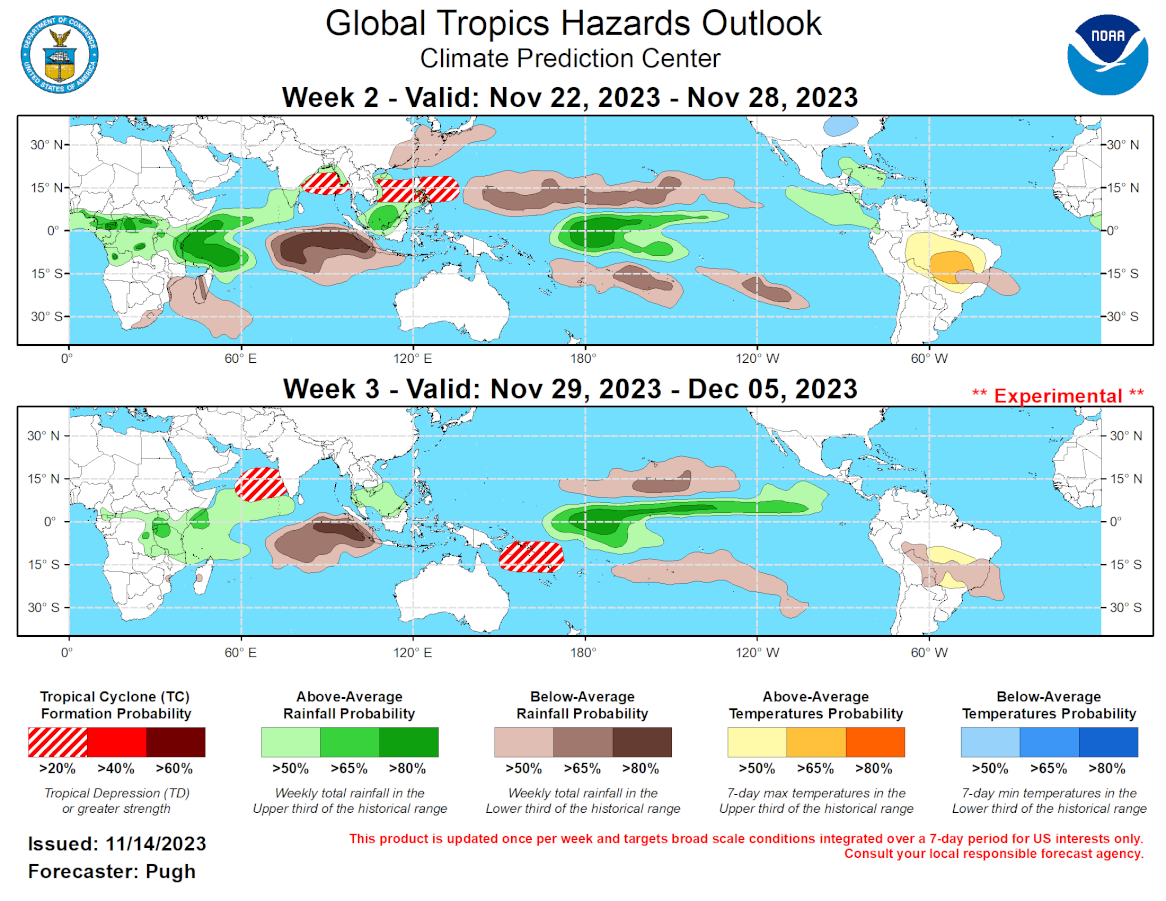
Last Updated - 11/21/23 Valid - 11/29/23 - 12/12/23 Against the backdrop of the stationary El Nino and positive Indian Ocean Dipole (+IOD) footprints that have dominated the global tropics this fall, the Madden-Julian Oscillation (MJO) continues to show signs of becoming much better organized which is reflected in latest RMM index and upper-level velocity potential anomaly observations. With the MJO propagating eastward and gaining amplitude over the Western Hemisphere during the past week, there is good agreement among the dynamical models RMM forecasts favoring continued eastward propagation of the MJO across the Indian Ocean, and entering the Maritime Continent toward the end of November. Favored changes of the strength of the MJO signal in RMM space appear to be tied to interference with the aforementioned low frequency modes of variability during the outlook period. Specifically, this includes constructive interference with the enhanced phase of +IOD resulting in a notable increase in amplitude during the next week, followed by a gradual decrease in amplitude where the MJO destructively interferes with the broadly suppressed low frequency convective footprint over the eastern Indian Ocean and Maritime Continent. However, the fact that many models are showing any semblance of MJO activity in phases 3 through 5 is significant, as this would be the first occurrence since early September and it portends a more sustained and coherent MJO exerting greater influence in the global tropics. This realization is supported by upper-level velocity potential anomaly forecasts which maintain a well-defined wave-1 pattern shifting eastward during the next several weeks, with the enhanced convective envelope returning to the Western Pacific near the middle of December. Given added forecast confidence for renewed MJO activity, the large-scale environment is expected to remain conducive for tropical cyclogenesis over the Indian Ocean during week-2, with more favorable conditions for development shifting eastward into the Western Pacific and south of the Equator later in the outlook period. The extratropical response associated with eastward propagating Indian Ocean MJO events during Oct-Dec typically leads to the development of mid-level ridging and warmer than normal temperatures over the central and eastern CONUS, falling more in-line with a positive North Atlantic Oscillation (+NAO) pattern. However, this downstream response appears more likely to occur beyond the week-2 period based on the latest model guidance. One tropical cyclone (TC) formed in the global tropics during the past week. TC Midhili formed on 11/16 in the Bay of Bengal and peaked at TS intensity before making landfall over Bangladesh. Before dissipating on 11/18, this system brought locally heavy rainfall and high winds that triggered flash flooding and damages to infrastructure in parts of the country. With the MJO forecast over the Indian Ocean, and predicted equatorial Rossby wave activity in the region, the Bay of Bengal looks to experience additional TC development heading into next week. With support from the GEFS and ECMWF ensembles, 40% chances of tropical cyclone (TC) development are posted where there has been good continuity in the probabilistic TC genesis tools featuring elevated signals in the basin. A secondary signal is also depicted in the tools over the Arabian Sea closer to the Greater Horn of Africa, but lower chances for TC formation are issued (20%) due to lesser support from the ensembles and the potential for the lower-level easterly wind response of the +IOD to linger north of the Equator and inhibit formation during week-2. Based on modest signals in the TC guidance, as well as TC composites indicating below-normal chances for development in the Western Pacific during Indian Ocean MJO events, no shapes are posted in the basin for week-2. For week-3, a broad area of 20% chances is posted from the Bay of Bengal to the Philippine Sea given agreement in the extended range guidance depicting the return of anomalous lower-level westerlies in the region, also supported by probabilistic tools. In the wake of the enhanced convective MJO envelope over the Indian Ocean, 20% chances are posted to the north of Madagascar given increased signals in the ECMWF and GEFS based probabilistic tools and support from TC composites during Maritime Continent MJO events. These MJO composites, as well as extended range guidance from the ECMWF also support 20% chances being posted over a broad area in the South Pacific from the Gulf of Carpentaria to the Date Line, as the basin is already off to an above-normal start to the TC season.
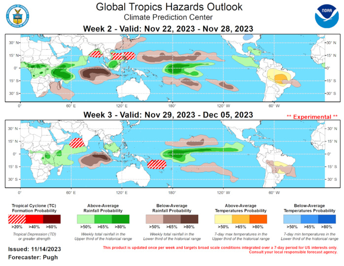
The precipitation outlook for weeks 2 and 3 are based on a historical skill weighted blend of the GEFS, CFSv2, ECCC, and ECMWF ensembles, influences from the El Nino and +IOD, with added consideration of Indian Ocean and Maritime Continent MJO event composites during Oct-Dec. Forecasts made over Africa are made in coordination with the International Desk at CPC. Tied to the +IOD and MJO, widespread enhanced rainfall remains favored throughout much of Africa during the next several weeks, where a continued wet pattern is likely to exacerbate saturated ground conditions for many areas experiencing ongoing flooding, particularly throughout the Greater Horn of Africa. For portions of South America, below- (above-) normal precipitation (temperatures) remains favored to further worsen soil moistures and prolong agriculture concerns through mid-December.
