Menu

Invest 91W under watch// 3 Week Tropical Cyclone Formation probability// 1512utc


CLICK ON THE IMAGERIES BELOW TO GET THEM ENLARGED
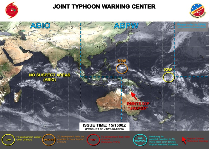
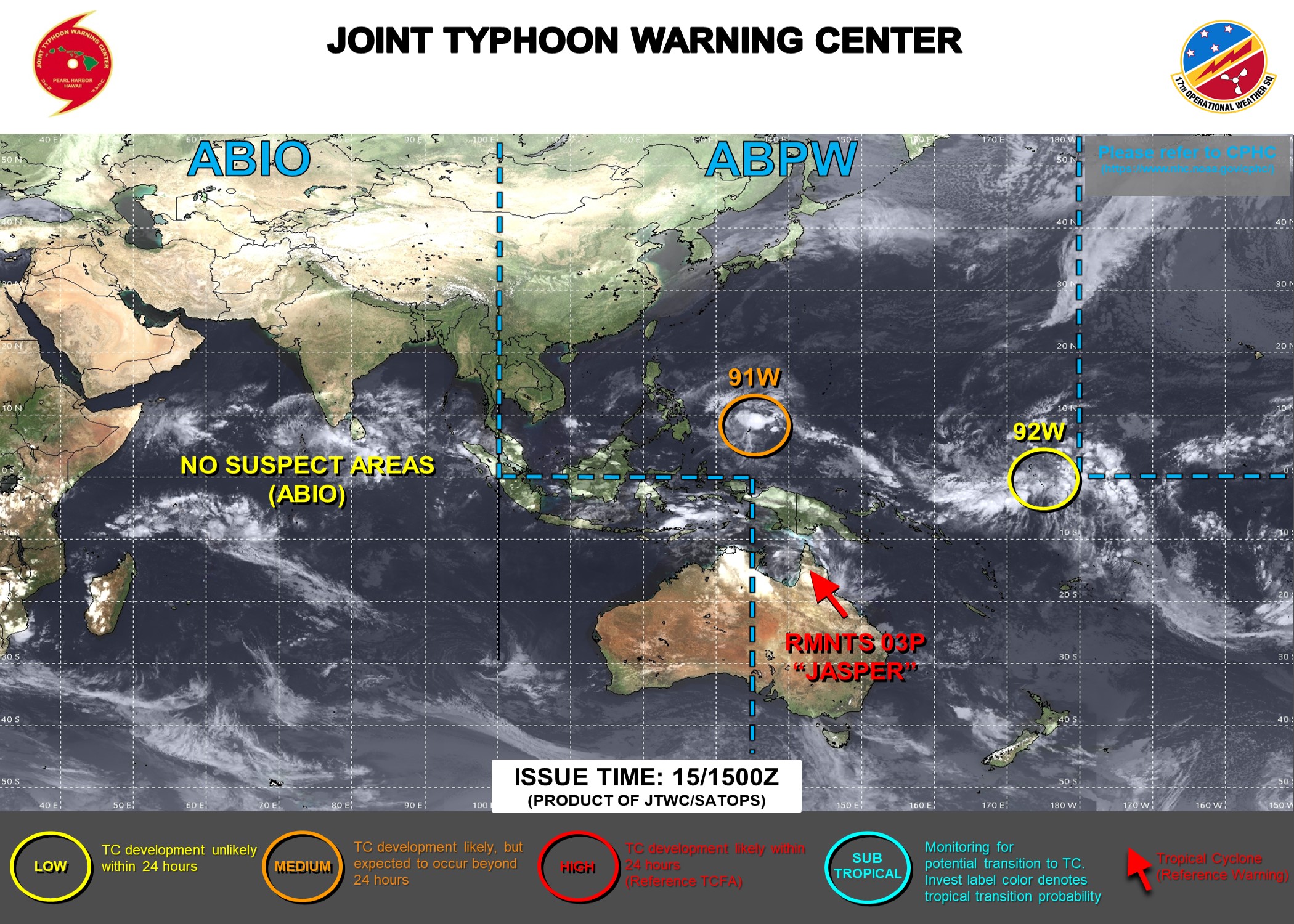
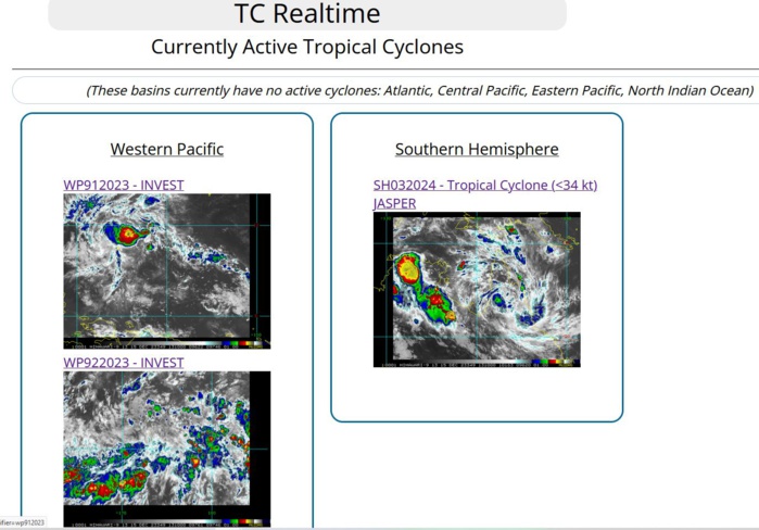
THE AREA OF CONVECTION (INVEST 91W) PREVIOUSLY LOCATED NEAR  3.4N 144.2E IS NOW LOCATED NEAR 4.9N 139.4E, APPROXIMATELY 319 NM  EAST-SOUTHEAST OF PALAU. ANIMATED MULTISPECTRAL SATELLITE IMAGERY  (MSI) HIGHLIGHTS THE OVERALL BROAD NATURE OF 91W AND ITS LOW LEVEL  CIRCULATION (LLC) BARELY PEAKING OUT OF THE SOUTHEASTERN PERIPHERY OF  ROBUST CONVECTION. ENVIRONMENTAL ANALYSIS REVEALS MARGINALLY FAVORABLE  CONDITIONS FOR DEVELOPMENT WITH VERY WARM (30-32C) SSTS, AND LOW TO  MODERATE (15-20 KTS) VERTICAL WIND SHEAR (VWS) OFFSET BY MODERATE  WESTWARD OUTFLOW ALOFT. GLOBAL DETERMINISTIC MODELS, SPECIFICALLY GFS  AND NAVGEM, DEPICT 91W TO CONSOLIDATE STEADILY WHILE TRACKING  NORTHWESTWARD TOWARDS THE SOUTHERN PHILIPPINE ARCHIPELAGO AND REACH  WARNING THRESHOLD (25 KTS INTENSITY) PRIOR TO LANDFALL. INTENSITY  GUIDANCE CONSENSUS SHOWS A STEADY BUILD UP TO TROPICAL DEPRESSION  STRENGTH OVER THE COURSE OF THE NEXT 48 HOURS.  MAXIMUM SUSTAINED  SURFACE WINDS ARE ESTIMATED AT 18 TO 23 KNOTS. MINIMUM SEA LEVEL  PRESSURE IS ESTIMATED TO BE NEAR 1004 MB. THE POTENTIAL FOR THE  DEVELOPMENT OF A SIGNIFICANT TROPICAL CYCLONE WITHIN THE NEXT 24 HOURS  REMAINS MEDIUM. -----------------------      (2) AN AREA OF CONVECTION (INVEST 92W) HAS PERSISTED NEAR 3.2N  172.2E, APPROXIMATELY 427 NM SOUTHEAST OF KWAJALEIN. ANIMATED ENHANCED  INFRARED (EIR) SATELLITE IMAGERY AND A 151038Z METOP-C SCATTEROMETER  PARTIAL PASS DEPICT A BROAD, POORLY ORGANIZED, LOW LEVEL CIRCULATION  (LLC) WITH FLARING CONVECTION ALONG THE SOUTHERN PERIPHERY.  ENVIRONMENTAL ANALYSIS REVEALS FAVORABLE CONDITIONS FOR DEVELOPMENT  WITH WARM (29-30C) SSTS, LOW (05-10 KTS) VERTICAL WIND SHEAR (VWS),  AND GOOD POLEWARD OUTFLOW ALOFT. GLOBAL NUMERICAL MODELS AGREE 92W  WILL SLOWLY CONSOLIDATE, STAYING QUASISTATIONARY OVER THE NEXT 72  HOURS. MAXIMUM SUSTAINED SURFACE WINDS ARE ESTIMATED AT 13 TO 17  KNOTS. MINIMUM SEA LEVEL PRESSURE IS ESTIMATED TO BE NEAR 1004 MB. THE  POTENTIAL FOR THE DEVELOPMENT OF A SIGNIFICANT TROPICAL CYCLONE WITHIN  THE NEXT 24 HOURS IS LOW.
THE AREA OF CONVECTION (INVEST 91W) PREVIOUSLY LOCATED NEAR 3.4N 144.2E IS NOW LOCATED NEAR 4.9N 139.4E, APPROXIMATELY 319 NM EAST-SOUTHEAST OF PALAU. ANIMATED MULTISPECTRAL SATELLITE IMAGERY (MSI) HIGHLIGHTS THE OVERALL BROAD NATURE OF 91W AND ITS LOW LEVEL CIRCULATION (LLC) BARELY PEAKING OUT OF THE SOUTHEASTERN PERIPHERY OF ROBUST CONVECTION. ENVIRONMENTAL ANALYSIS REVEALS MARGINALLY FAVORABLE CONDITIONS FOR DEVELOPMENT WITH VERY WARM (30-32C) SSTS, AND LOW TO MODERATE (15-20 KTS) VERTICAL WIND SHEAR (VWS) OFFSET BY MODERATE WESTWARD OUTFLOW ALOFT. GLOBAL DETERMINISTIC MODELS, SPECIFICALLY GFS AND NAVGEM, DEPICT 91W TO CONSOLIDATE STEADILY WHILE TRACKING NORTHWESTWARD TOWARDS THE SOUTHERN PHILIPPINE ARCHIPELAGO AND REACH WARNING THRESHOLD (25 KTS INTENSITY) PRIOR TO LANDFALL. INTENSITY GUIDANCE CONSENSUS SHOWS A STEADY BUILD UP TO TROPICAL DEPRESSION STRENGTH OVER THE COURSE OF THE NEXT 48 HOURS. MAXIMUM SUSTAINED SURFACE WINDS ARE ESTIMATED AT 18 TO 23 KNOTS. MINIMUM SEA LEVEL PRESSURE IS ESTIMATED TO BE NEAR 1004 MB. THE POTENTIAL FOR THE DEVELOPMENT OF A SIGNIFICANT TROPICAL CYCLONE WITHIN THE NEXT 24 HOURS REMAINS MEDIUM. ----------------------- (2) AN AREA OF CONVECTION (INVEST 92W) HAS PERSISTED NEAR 3.2N 172.2E, APPROXIMATELY 427 NM SOUTHEAST OF KWAJALEIN. ANIMATED ENHANCED INFRARED (EIR) SATELLITE IMAGERY AND A 151038Z METOP-C SCATTEROMETER PARTIAL PASS DEPICT A BROAD, POORLY ORGANIZED, LOW LEVEL CIRCULATION (LLC) WITH FLARING CONVECTION ALONG THE SOUTHERN PERIPHERY. ENVIRONMENTAL ANALYSIS REVEALS FAVORABLE CONDITIONS FOR DEVELOPMENT WITH WARM (29-30C) SSTS, LOW (05-10 KTS) VERTICAL WIND SHEAR (VWS), AND GOOD POLEWARD OUTFLOW ALOFT. GLOBAL NUMERICAL MODELS AGREE 92W WILL SLOWLY CONSOLIDATE, STAYING QUASISTATIONARY OVER THE NEXT 72 HOURS. MAXIMUM SUSTAINED SURFACE WINDS ARE ESTIMATED AT 13 TO 17 KNOTS. MINIMUM SEA LEVEL PRESSURE IS ESTIMATED TO BE NEAR 1004 MB. THE POTENTIAL FOR THE DEVELOPMENT OF A SIGNIFICANT TROPICAL CYCLONE WITHIN THE NEXT 24 HOURS IS LOW.

INVEST 91W

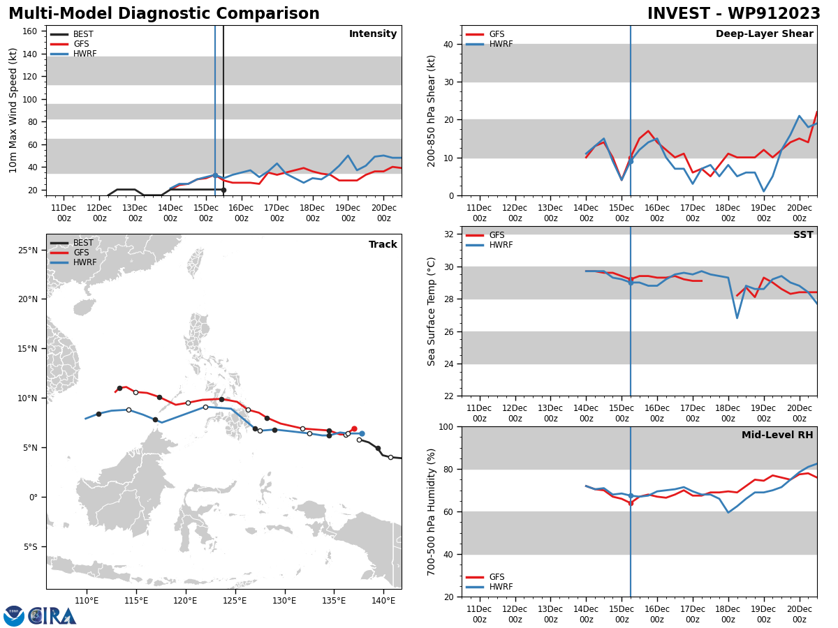
GLOBAL DETERMINISTIC MODELS, SPECIFICALLY GFS  AND NAVGEM, DEPICT 91W TO CONSOLIDATE STEADILY WHILE TRACKING  NORTHWESTWARD TOWARDS THE SOUTHERN PHILIPPINE ARCHIPELAGO AND REACH  WARNING THRESHOLD (25 KTS INTENSITY) PRIOR TO LANDFALL. INTENSITY  GUIDANCE CONSENSUS SHOWS A STEADY BUILD UP TO TROPICAL DEPRESSION  STRENGTH OVER THE COURSE OF THE NEXT 48 HOURS.
GLOBAL DETERMINISTIC MODELS, SPECIFICALLY GFS AND NAVGEM, DEPICT 91W TO CONSOLIDATE STEADILY WHILE TRACKING NORTHWESTWARD TOWARDS THE SOUTHERN PHILIPPINE ARCHIPELAGO AND REACH WARNING THRESHOLD (25 KTS INTENSITY) PRIOR TO LANDFALL. INTENSITY GUIDANCE CONSENSUS SHOWS A STEADY BUILD UP TO TROPICAL DEPRESSION STRENGTH OVER THE COURSE OF THE NEXT 48 HOURS.


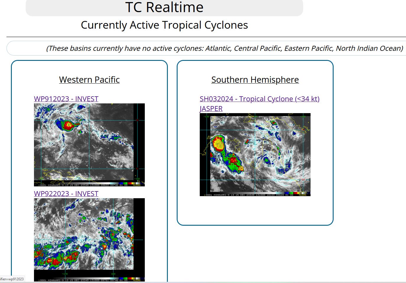
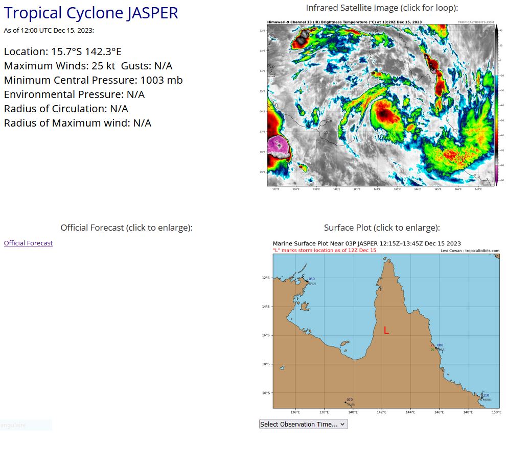
JTWC IS STILL ISSUING 3HOURLY SATELLITE BULLETINS ON THE OVER-LAND REMNANTS OF TC 03P(JASPER).


Last Updated - 12/12/23

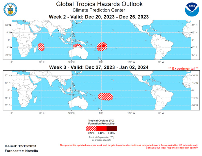
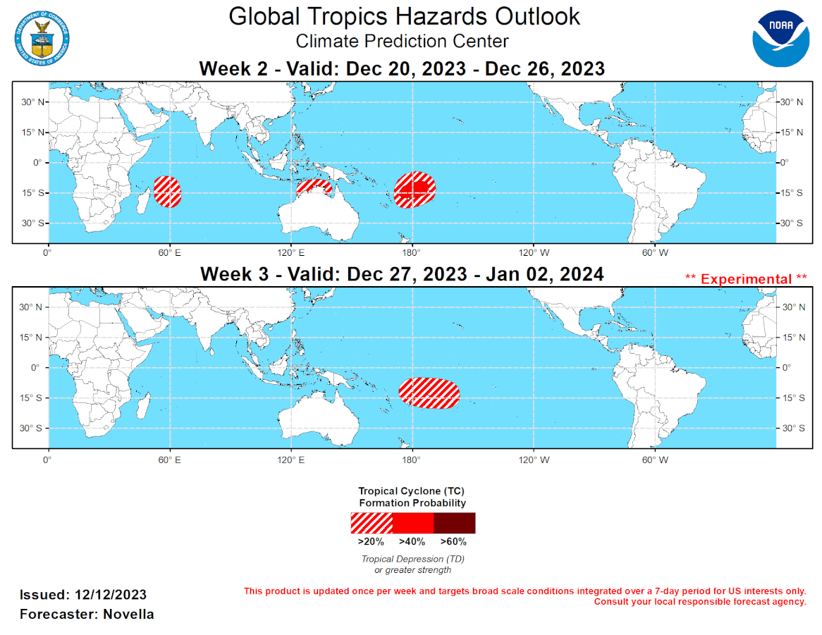
No Tropical Cyclones (TCs) formed during the past week, though TC Jasper remains active in the South Pacific since forming on 12/4. Currently at Tropical Storm intensity, the Joint Typhoon Warning Center (JTWC) forecasts Jasper to make landfall within the next 24 hours over the Cape York Peninsula of eastern Australia. Based on model guidance, locally heavy amounts of precipitation and periods of high winds are favored over many northern parts of the Queensland State of Australia in the next day or so. The official JTWC forecast shows Jasper dissipating over land, however several deterministic solutions show the remnant low exiting into the Gulf of Carpentaria early in week-1. There is substantial spread in the ensembles, but probabilistic TC tools maintain elevated signals for potential (re)development either in the Gulf of Carpentaria or over the Timor or Arafura Seas. While any formation appears more likely to occur later in week-1, 20% chances are issued over the region for week-2 based on probabilistic tools, warm SSTs (near 30 degrees C), and a decreased shear environment favored next week.  Across the Indian Ocean, 20% chances for TC development are issued to the northeast of Madagascar given the aforementioned Kelvin wave activity and model agreement depicting an area of deepening low pressure later in week-1. Additional TC formation is also possible over the Bay of Bengal, however no corresponding TC shapes are posted due to decreasing support in the probabilistic tools and climatology. These tools also point to TC development in the western Pacific, however the lower-level wind and shear environment appear to become increasingly unfavorable for genesis by the start of week-2, and no shape is issued. In the South Pacific, the TC season is already off to a robust start in the eastern portion of the basin likely due to ENSO. With strongly anomalous lower level westerlies favored through the end of December, 40% chances are posted near the Fiji Islands, with a broad 20% area spanning both hemispheres for week-2. 20% chances are likewise posted for week-3 for approximately the same region in the South Pacific based on support in the extended range guidance and TC composites for Western Hemisphere MJO events during Nov-Jan.
No Tropical Cyclones (TCs) formed during the past week, though TC Jasper remains active in the South Pacific since forming on 12/4. Currently at Tropical Storm intensity, the Joint Typhoon Warning Center (JTWC) forecasts Jasper to make landfall within the next 24 hours over the Cape York Peninsula of eastern Australia. Based on model guidance, locally heavy amounts of precipitation and periods of high winds are favored over many northern parts of the Queensland State of Australia in the next day or so. The official JTWC forecast shows Jasper dissipating over land, however several deterministic solutions show the remnant low exiting into the Gulf of Carpentaria early in week-1. There is substantial spread in the ensembles, but probabilistic TC tools maintain elevated signals for potential (re)development either in the Gulf of Carpentaria or over the Timor or Arafura Seas. While any formation appears more likely to occur later in week-1, 20% chances are issued over the region for week-2 based on probabilistic tools, warm SSTs (near 30 degrees C), and a decreased shear environment favored next week. Across the Indian Ocean, 20% chances for TC development are issued to the northeast of Madagascar given the aforementioned Kelvin wave activity and model agreement depicting an area of deepening low pressure later in week-1. Additional TC formation is also possible over the Bay of Bengal, however no corresponding TC shapes are posted due to decreasing support in the probabilistic tools and climatology. These tools also point to TC development in the western Pacific, however the lower-level wind and shear environment appear to become increasingly unfavorable for genesis by the start of week-2, and no shape is issued. In the South Pacific, the TC season is already off to a robust start in the eastern portion of the basin likely due to ENSO. With strongly anomalous lower level westerlies favored through the end of December, 40% chances are posted near the Fiji Islands, with a broad 20% area spanning both hemispheres for week-2. 20% chances are likewise posted for week-3 for approximately the same region in the South Pacific based on support in the extended range guidance and TC composites for Western Hemisphere MJO events during Nov-Jan.

Rédigé par PATRICK HOAREAU le Friday, December 15th 2023 à 18:08