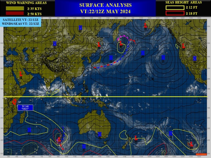
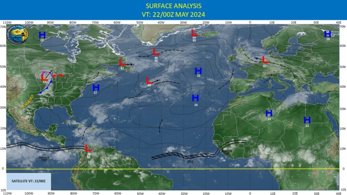
CLICK ON THE IMAGERIES BELOW TO GET THEM ENLARGED
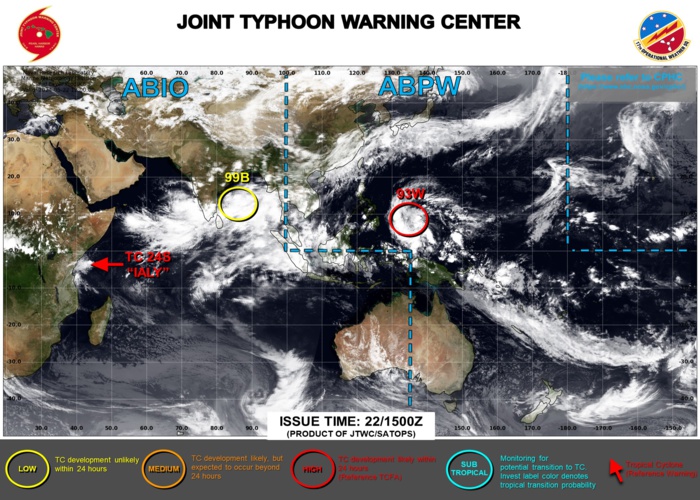
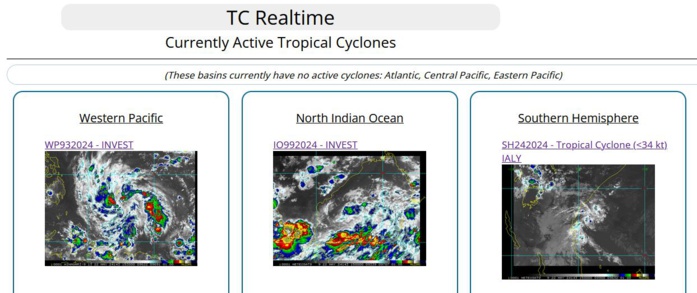
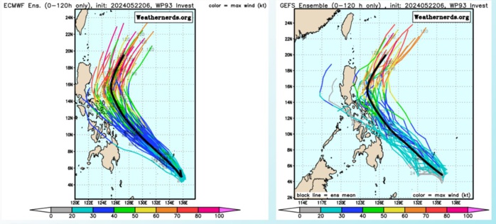
WESTERN NORTH PACIFIC: TROPICAL CYCLONE FORMATION ALERT ISSUED AT 22/14UTC. ESTIMATED INTENSITY AT 22/12UTC IS 20 KNOTS.
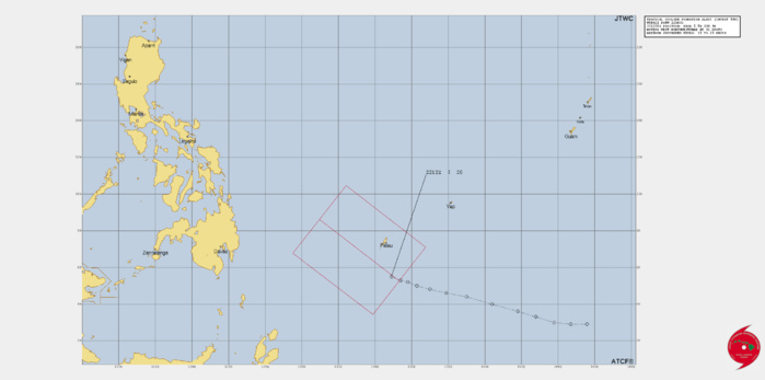
THE AREA OF CONVECTION (INVEST 93W) PREVIOUSLY LOCATED NEAR 4.8N 137.7E IS NOW LOCATED NEAR 5.5N 134.9E, APPROXIMATELY 112 NM SOUTH OF PALAU. ANIMATED MULTISPECTRAL SATELLITE IMAGERY DEPICTS 93S OBSCURED BY PERSISTENT DEEP CONVECTION WRAPPING INTO THE CENTER FROM THE NORTHWEST. A 220908Z SSIMS 91GHZ IMAGE DEPICTS A CONSOLIDATED LOW LEVEL CIRCULATION CENTER (LLCC) WITH FORMATIVE BANDING WRAPPING FROM THE SOUTHWEST. THE ENVIRONMENT IS FAVORABLE FOR DEVELOPMENT WITH WARM SEA SURFACE TEMPERATURES (29-30C) AND LOW VERTICAL WIND SHEAR (5-10KTS). THE UPPER-LEVEL ENVIRONMENT IS FAVORABLE FOR INTENSIFICATION AS A POINT SOURCE ALOFT FEEDS IN TO A UPPER-LEVEL TROUGH TO THE NORTHWEST THAT IS SUPPORTING THE SYSTEM. GLOBAL DETERMINISTIC AND ENSEMBLE MODELS ARE IN GOOD AGREEMENT THAT 93W WILL CONTINUE TO TRACK NORTHWESTWARD WITH STEADY INTENSIFICATION OVER THE NEXT 24 HOURS. MAXIMUM SUSTAINED SURFACE WINDS ARE ESTIMATED AT 18 TO 23 KNOTS. MINIMUM SEA LEVEL PRESSURE IS ESTIMATED TO BE NEAR 1007 MB. THE POTENTIAL FOR THE DEVELOPMENT OF A SIGNIFICANT TROPICAL CYCLONE WITHIN THE NEXT 24 HOURS IS UPGRADED TO HIGH.
9324051912 29N1456E 15
9324051918 29N1447E 15
9324052000 30N1438E 15
9324052006 33N1428E 15
9324052012 36N1418E 15
9324052018 40N1404E 15
9324052100 44N1390E 15
9324052106 46N1379E 15
9324052112 48N1370E 15
9324052118 50N1363E 15
9324052200 52N1358E 15
9324052206 53N1354E 20
9324052212 55N1349E 20
9324051918 29N1447E 15
9324052000 30N1438E 15
9324052006 33N1428E 15
9324052012 36N1418E 15
9324052018 40N1404E 15
9324052100 44N1390E 15
9324052106 46N1379E 15
9324052112 48N1370E 15
9324052118 50N1363E 15
9324052200 52N1358E 15
9324052206 53N1354E 20
9324052212 55N1349E 20
CLICK ON THE IMAGERY BELOW TO GET IT ANIMATED AND ENLARGED
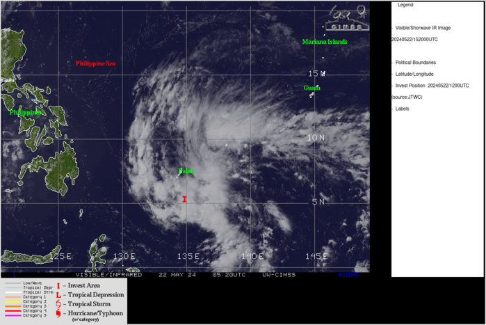
ANIMATED MULTISPECTRAL SATELLITE IMAGERY DEPICTS 93W OBSCURED BY PERSISTENT DEEP CONVECTION WRAPPING INTO THE CENTER FROM THE NORTHWEST.
Model Diagnostic Plot
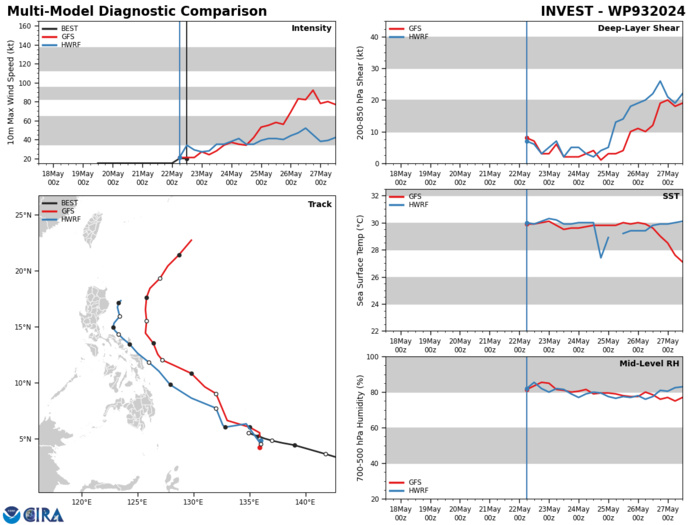
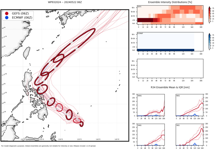
GLOBAL DETERMINISTIC AND ENSEMBLE MODELS ARE IN GOOD AGREEMENT THAT 93W WILL CONTINUE TO TRACK NORTHWESTWARD WITH STEADY INTENSIFICATION OVER THE NEXT 24 HOURS.
Ensemble Track Ellipses
TC Ensemble Forecasts: 120H
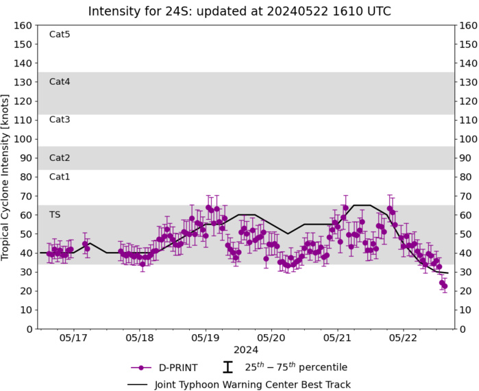
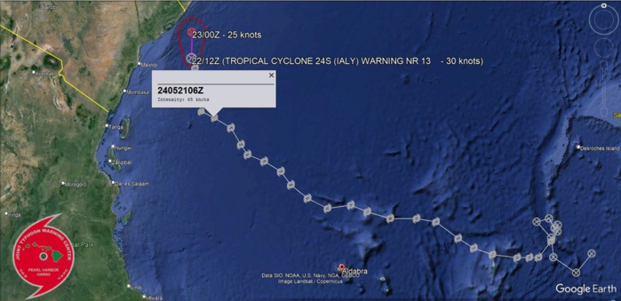
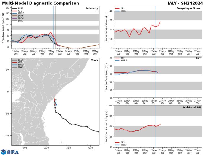
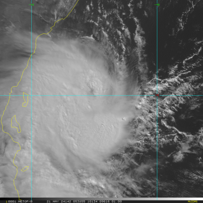
SOUTH INDIAN OCEAN: TC 24S(IALY). ESTIMATED PEAK INTENSITY WAS 65 KNOTS/CAT 1 US.
2424051400 90S 543E 20
2424051406 96S 538E 20
2424051412 91S 530E 25
2424051418 85S 529E 25
2424051500 80S 524E 25
2424051506 79S 528E 30
2424051512 82S 530E 30
2424051518 81S 531E 30
2424051600 83S 531E 30
2424051606 86S 529E 35
2424051612 91S 525E 40
2424051618 91S 522E 40
2424051700 91S 518E 40
2424051706 90S 510E 45
2424051712 88S 504E 40
2424051718 85S 499E 40
2424051800 80S 492E 40
2424051806 79S 486E 40
2424051812 79S 478E 45
2424051818 77S 471E 50
2424051900 75S 466E 55
2424051906 76S 459E 55
2424051912 73S 453E 60
2424051918 69S 448E 60
2424052000 65S 445E 55
2424052006 62S 440E 50
2424052012 60S 435E 55
2424052018 57S 433E 55
2424052100 52S 430E 55
2424052106 49S 425E 65
2424052112 47S 421E 65
2424052118 41S 419E 60
2424052200 37S 419E 45
2424052206 34S 419E 35
2424052212 31S 418E 30
Model Diagnostic Plot
TC 24S NEAR PEAK INTENSITY AT 21/0532UTC
NORTH INDIAN/BAY OF BENGAL: INVEST 99B. ADVISORY(ABIO) UPDATED AT 22/15UTC
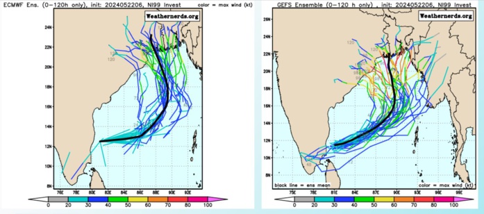
THE AREA OF CONVECTION (INVEST 99B) PREVIOUSLY LOCATED NEAR 12.5N 81.0E IS NOW LOCATED NEAR 14.0N 83.6E, APPROXIMATELY 204 NM EAST- NORTHEAST OF CHENNAI. ANIMATED ENHANCED INFRARED SATELLITE IMAGERY DEPICTS A HIGHLY BROAD CIRCULATION AREA OFFSHORE OF CHENNAI, INDIA WITH SPOTTY CONVECTION. A MID-LEVEL CIRCULATION IS OBSERVED DISPLACED 250 TO 300 NM EAST OF THE SURFACE CIRCULATION, INDICATING A DISORGANIZED SYSTEM. A 211523Z ASCAT PASS SHOWS A LARGE ELLIPTICAL AREA OF TURNING WITH AN ASYMMETRIC WIND FIELD, CONSISTING OF LIGHT EASTERLIES TO THE NORTH AND A MONSOONAL WESTERLY WIND BURST SOUTH OF SRI LANKA WITH 25-30 KT WINDS THAT ARE NOT DIRECTLY ASSOCIATED WITH THE CIRCULATION AT THIS TIME. CURRENT ENVIRONMENTAL ANALYSIS SHOWS FAVORABLE CONDITIONS WITH WEAK (
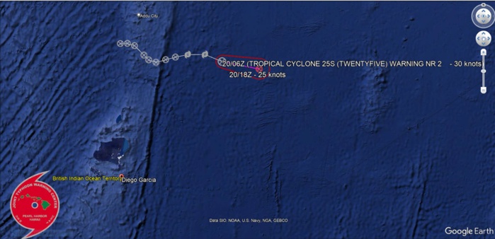
SOUTH INDIAN OCEAN: TC 25S. SHORT LIVED. ESTIMATED PEAK INTENSITY WAS 35 KNOTS
2524051718 18S 724E 15
2524051800 18S 727E 15
2524051806 19S 730E 20
2524051812 23S 734E 20
2524051818 25S 736E 30
2524051900 26S 739E 30
2524051906 25S 743E 25
2524051912 24S 747E 30
2524051918 23S 752E 35
2524052000 23S 759E 35
2524052006 26S 766E 30
2524051800 18S 727E 15
2524051806 19S 730E 20
2524051812 23S 734E 20
2524051818 25S 736E 30
2524051900 26S 739E 30
2524051906 25S 743E 25
2524051912 24S 747E 30
2524051918 23S 752E 35
2524052000 23S 759E 35
2524052006 26S 766E 30
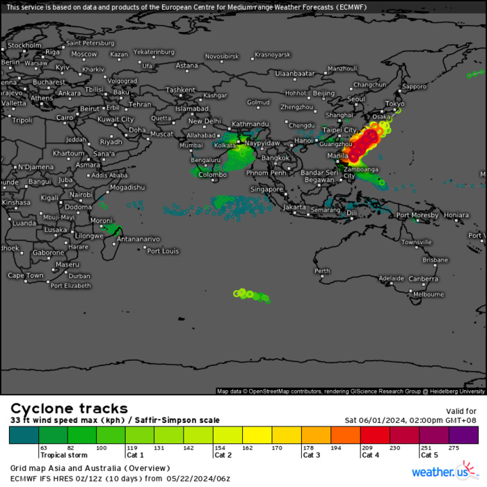
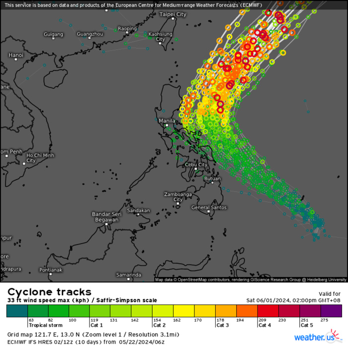
ECMWF Storm Tracks (Ensemble) : 05/22 06UTC+ 10 DAYS
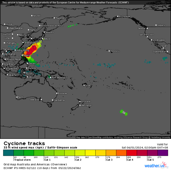
ECMWF Storm Tracks (Ensemble) : 05/22 06UTC+ 10 DAYS
ECMWF Storm Tracks (Ensemble) : 05/22 06UTC+ 10 DAYS
Last Updated - 05/21/24 3 WEEK TROPICAL CYCLONE FORMATION PROBABILITY
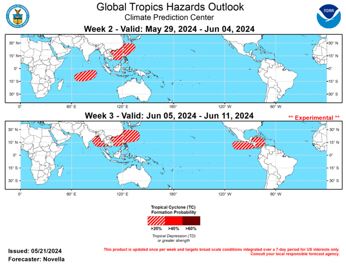
GTH Outlook Discussion Last Updated - 05/21/24 Valid - 05/29/24 - 06/11/24 As previously forecast, the Madden-Juilan Oscillation (MJO) showed better signs of reorganization over the Indian Ocean during the past week. The renewal is well supported in RMM space which continues to depict an emerging and eastward propagating signal over phase 3, as well as the upper-level velocity potential anomaly fields which reveal a better spatial definition of the enhanced and suppressed envelopes across the global tropics. Objective wavenumber-frequency filtering of these anomaly fields also show a good deal of continued equatorial Kelvin and Rossby wave activity in the eastern Hemisphere, which has aided in the large-scale enhancement of convection and divergence aloft over the Indian Ocean. The tropical perspective largely remains on track since last week, as dynamical models are supportive of the continued eastward propagation of the MJO over the Maritime Continent. Tropical Cyclone (TC) development remains favored in the Indian Ocean and western Pacific through the end of May, however the MJO picture becomes much less clear heading later into June. Consistent with the two previous trips of the MJO over the Maritime Continent this spring, RMM forecasts feature a rapid weakening of the signal over phase 5 early next month with some ensemble members reaching the western Pacific at a low amplitude. Upper-level velocity potential anomaly forecasts from the GEFS, CFSv2, and ECMWF have fallen more in-line with the weaker RMM guidance, but suggest that any disorganization may be tied to destructive interference with an emerging low frequency circulation response over the Maritime Continent. Such a response would be consistent, albeit early, with the transitioning ENSO state, as any western Pacific and/or western Hemisphere MJO activity may have difficulty maintaining a canonical wave-1 structure propagating eastward with time. Notwithstanding, objective filtering of these fields do show some semblance of MJO activity and enhanced divergence aloft reaching the tropical Americas (mainly expressed north of the equator) by the week-3 period, which could provide more favorable conditions for tropical cyclogenesis over the eastern Pacific and the Caribbean later in June. The recent amplification of the MJO, as well as the aforementioned modes of tropical variability traversing the Indian Ocean, resulted in a strong uptick in lower-level westerlies along the equator, and generated a pair of remarkably low-latitude, late season TCs forming in the southern basin. Since forming on 5/17 near 9S/53E, TC Ialy strengthened to Tropical Storm intensity while recurving northwestward under the steering influence of a subtropical ridge over eastern equatorial Africa. The Joint Typhoon Warning Center (JTWC) expects Ialy to succumb to dry air entrainment and fully dissipate in the next day or so, though its remnant circulation may bring elevated winds and increased precipitation amounts to parts of coastal Kenya and southern Somalia. Farther east, TC 25S formed near 2S/75E on 5/19 and dissipated earlier today. Despite being weak and short-lived, this TC is notable for forming so close to the equator where Coriolis is nearly zero, and underscores the potency of the strengthening equatorial westerlies associated with the renewed MJO. During week-1, lower-level wind anomaly forecasts feature another surge of westerlies (possible wind burst event) between 80E to 90E along the equator favorable for additional TC development. Deterministic model solutions are nearly unanimous in forming a TC in the Bay of Bengal later this week, however a secondary signal emerges in the probabilistic TC genesis tools south of the equator late in week-1. Usually, climatology dictates that any TC potential south of the equator would be rather dubious for late May, but in light of the multiple TCs forming in the southern Indian Ocean during the past week, this potential is not being ruled out and 20% chances for genesis are posted from approximately 65E to 90E in the week-2 outlook. Following potential TC development favored to the east of the Philippines during week-1, 20% chances are also posted from the South China Sea to the south of Japan where anomalous lower-level westerlies and deepening mean low pressure are favored in the GEFS and ECMWF ensembles, with support from TC composites featuring increased chances above climatology during Apr-Jun phase 4 and 5 MJO events in the highlighted area. Based on these composites and extended range probabilistic TC tools maintaining increased signals for TC development in the northern Indian Ocean and western Pacific, 20% chances are issued from the Bay of Bengal to the Philippine Sea for week-3. Higher chances (40%) were considered based on the GEFS, however the ECMWF remains more muted with this potential. Despite some of the uncertainties with the coherence of the MJO as it propagates eastward, there is good agreement between the GEFS and ECMWF featuring a flip from an enhanced trade regime to anomalous lower-level westerlies overspreading the tropical Americas during week-3. With more favorable upper-level conditions predicted to help relax shear, and record breaking warm sea surface temperatures in the Caribbean (much of the region is well in excess of 29 degrees C), 20% chances for TC development are also issued from the eastern Pacific to the southwestern Caribbean.
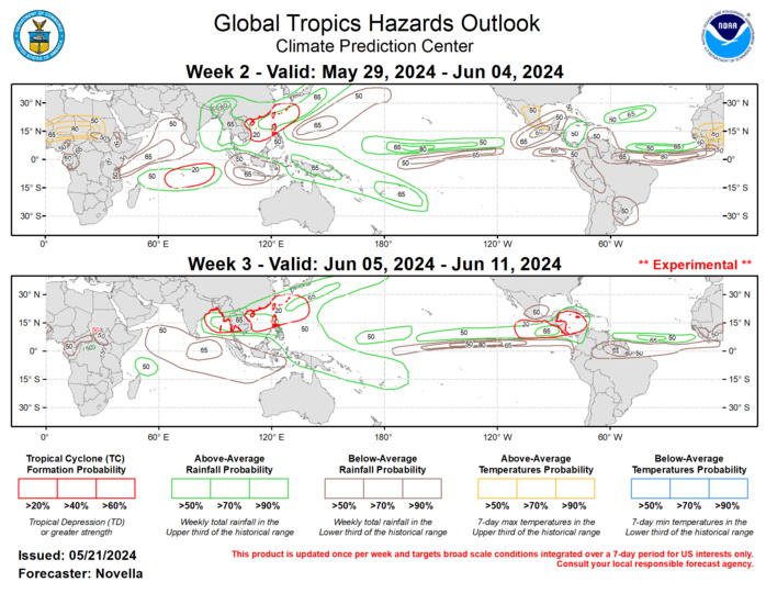
The precipitation outlook for weeks 2 and 3 are based on a historical skill weight blend of GEFS, CFSv2, ECCC, and ECMWF ensemble mean guidance, MJO composites, and anticipated TC tracks. For temperatures, pre-monsoonal heat is favored to persist across many parts of Sahelian and Saharan Africa where daytime highs may possibly exceed 110 degrees F in week-2 based on calibrated reforecast temperature tools. Excessive heat conditions may also persist over parts of southern Texas and Florida early in week-2. For hazardous weather conditions in your area during the next two weeks, please refer to your local NWS office, the Medium Range Hazards Forecast from the Weather Prediction Center (WPC), and the CPC Week-2 Hazards Outlook. Forecasts issued over Africa are made in coordination with the International Desk at CPC.
