Menu

3 Week Tropical Cyclone Formation probability : Southern Hemisphere likely to be active// 1003utc


CLICK ON THE IMAGERIES BELOW TO GET THEM ENLARGED

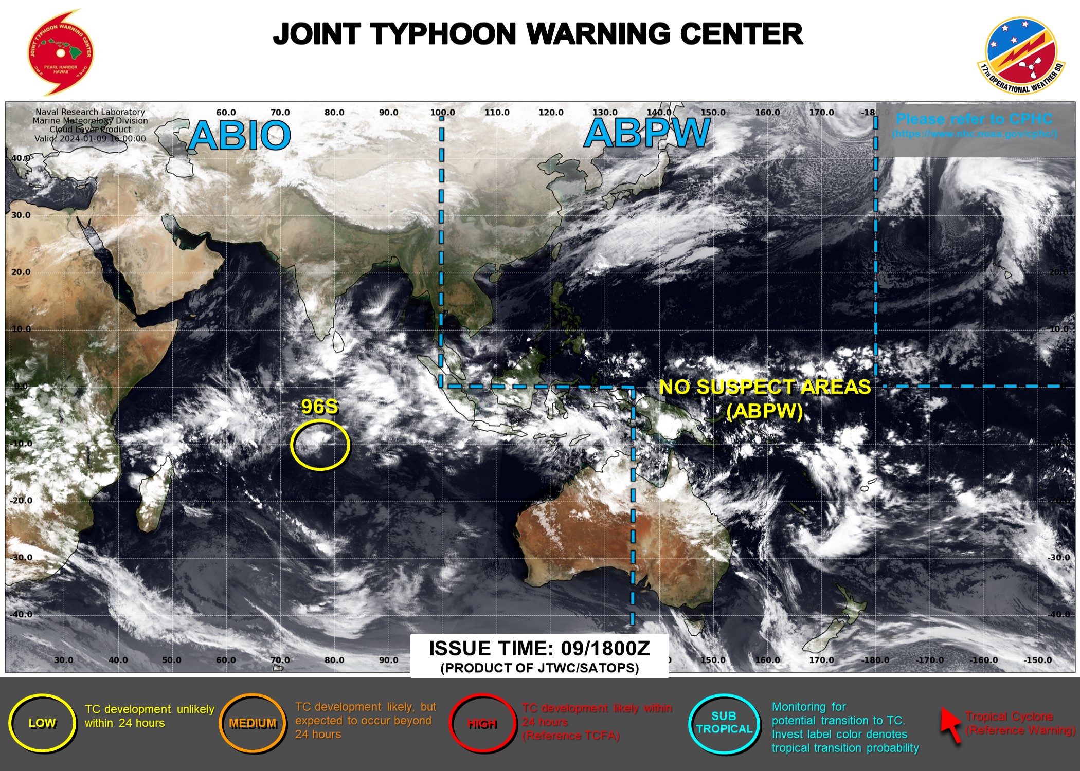
UPDATED AT 01/09/18UTC.THE AREA OF CONVECTION (INVEST 96S) PREVIOUSLY LOCATED NEAR  8.9S 78.7E IS NOW LOCATED NEAR 8.6S 78.8E, APPROXIMATELY 383 NM EAST OF  DIEGO GARCIA. ANIMATED ENHANCED INFRARED (EIR) SATELLITE IMAGERY SHOWS A  PARTIALLY EXPOSED LOW LEVEL CIRCULATION CENTER (LLCC) WITH DEEP  CONVECTION PERSISTING ALONG THE WESTERN PERIPHERIES. THE CIRCULATION IS  PASSING OVER VERY WARM WATER (29-30C) BUT CURRENTLY LIES IN AN AREA OF  MODERATE TO HIGH (20-25 KTS) EASTERLY VERTICAL WIND SHEAR WITH WEAK  UPPER LEVEL OUTFLOW. INVEST 96S IS EXPECTED TO CONTINUE ON AN  EQUATORWARD TRACK INTO A ZONE OF HIGHER SHEAR OVER THE NEXT FEW DAYS.  MAXIMUM SUSTAINED SURFACE WINDS ARE ESTIMATED AT 18 TO 22 KNOTS. MINIMUM  SEA LEVEL PRESSURE IS ESTIMATED TO BE NEAR 1009 MB. THE POTENTIAL FOR  THE DEVELOPMENT OF A SIGNIFICANT TROPICAL CYCLONE WITHIN THE NEXT 24  HOURS REMAINS LOW.
UPDATED AT 01/09/18UTC.THE AREA OF CONVECTION (INVEST 96S) PREVIOUSLY LOCATED NEAR 8.9S 78.7E IS NOW LOCATED NEAR 8.6S 78.8E, APPROXIMATELY 383 NM EAST OF DIEGO GARCIA. ANIMATED ENHANCED INFRARED (EIR) SATELLITE IMAGERY SHOWS A PARTIALLY EXPOSED LOW LEVEL CIRCULATION CENTER (LLCC) WITH DEEP CONVECTION PERSISTING ALONG THE WESTERN PERIPHERIES. THE CIRCULATION IS PASSING OVER VERY WARM WATER (29-30C) BUT CURRENTLY LIES IN AN AREA OF MODERATE TO HIGH (20-25 KTS) EASTERLY VERTICAL WIND SHEAR WITH WEAK UPPER LEVEL OUTFLOW. INVEST 96S IS EXPECTED TO CONTINUE ON AN EQUATORWARD TRACK INTO A ZONE OF HIGHER SHEAR OVER THE NEXT FEW DAYS. MAXIMUM SUSTAINED SURFACE WINDS ARE ESTIMATED AT 18 TO 22 KNOTS. MINIMUM SEA LEVEL PRESSURE IS ESTIMATED TO BE NEAR 1009 MB. THE POTENTIAL FOR THE DEVELOPMENT OF A SIGNIFICANT TROPICAL CYCLONE WITHIN THE NEXT 24 HOURS REMAINS LOW.

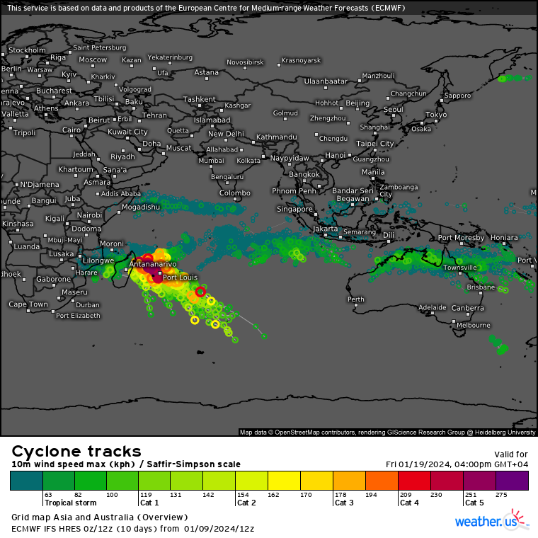
Storm Tracks (Ensemble) : 01/09 12UTC+ 10 DAYS


Last Updated - 01/09/24

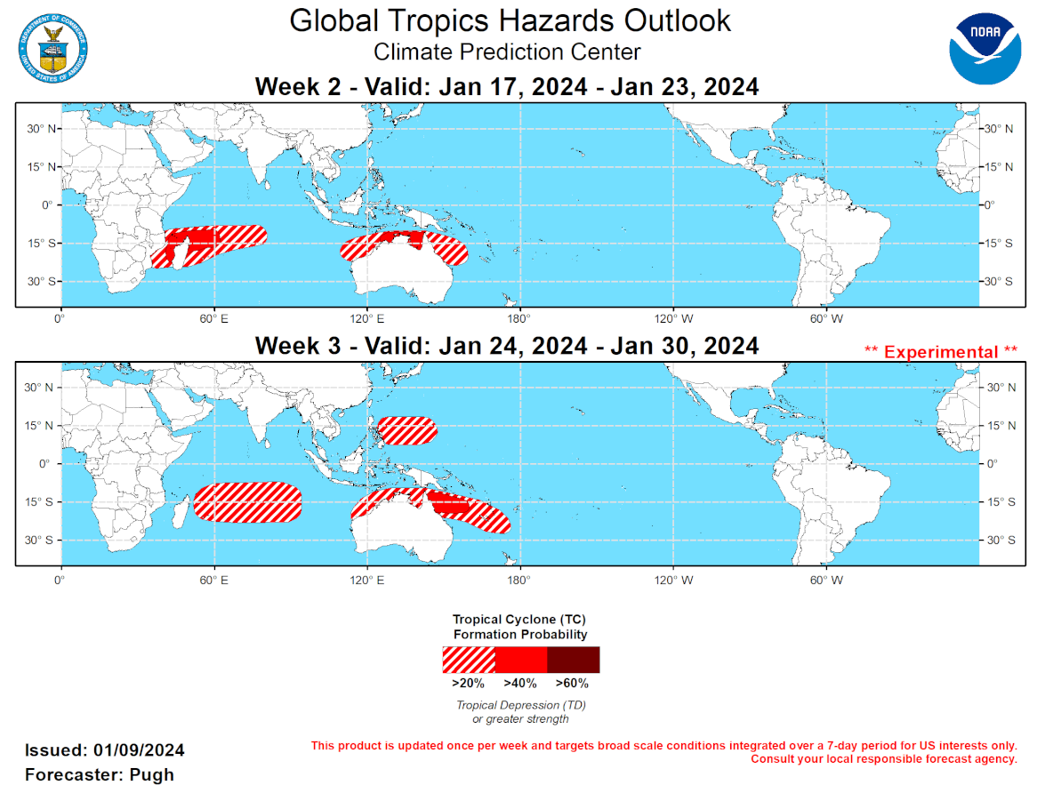
GTH Outlook Discussion Last Updated - 01/09/24 Valid - 01/17/24 - 01/30/24 A long-lived Madden-Julian Oscillation (MJO) completed a circumnavigation of the global tropics by the end of December when it began to overspread the Indian Ocean. Since the beginning of the New Year, the MJO amplitude decreased and its eastward propagation slowed due to destructive interference with the lingering positive phase of the Indian Ocean Dipole (+IOD) and an equatorial Rossby wave. The MJO was strong enough to briefly cause low-level westerly wind anomalies, associated with El Nino, to become easterly at the Date Line. Also, there was a significant increase in convection across the eastern Indian Ocean as the +IOD shows signs of weakening. The 200-hPa velocity potential anomaly field became less coherent recently as an atmospheric Kelvin wave progresses east over the Western Hemisphere. By January 8, the MJO RMM index shifted from phase 3 to 2 over the Indian Ocean which is likely due to influence from the equatorial Rossby wave. Dynamical models (GEFS, ECMWF, and Canadian) remain consistent and in good agreement that the MJO resumes eastward propagation to the Maritime Continent and West Pacific during the next two to three weeks. However, ensemble spread is large on its amplitude and speed with the GEFS favoring a stronger and slower MJO into late January.  No tropical cyclones formed from January 3 to 9 since the favorable MJO phases coincided with the Atlantic basin. As the MJO propagates eastward from the Indian to Pacific Ocean, the large-scale environment is likely to become more favorable for tropical cyclone (TC) development across the South Indian Ocean and areas surrounding northern Australia during mid-January. Prior to week-2, multiple TCs could develop across the South Indian Ocean and Arabian Sea. The GEFS and ECMWF ensemble members support a 40 percent chance of TC development across the Mozambique Channel and to the east of Madagascar during week-2 (January 17-23). A broader 20 percent chance covers more of the South Indian Ocean and extends through week-3 (January 24-30), based on MJO composites and dynamical output. A consensus between the GFS and ECMWF models results in a 40 percent chance of TC genesis for the Gulf of Carpentaria and near the Top End of Australia during week-2. The most favored area for TC development during week-3 shifts east to the Coral Sea region, while dynamical models and MJO composites support a 20 percent chance area near northern Australia and the West Pacific later in January.
GTH Outlook Discussion Last Updated - 01/09/24 Valid - 01/17/24 - 01/30/24 A long-lived Madden-Julian Oscillation (MJO) completed a circumnavigation of the global tropics by the end of December when it began to overspread the Indian Ocean. Since the beginning of the New Year, the MJO amplitude decreased and its eastward propagation slowed due to destructive interference with the lingering positive phase of the Indian Ocean Dipole (+IOD) and an equatorial Rossby wave. The MJO was strong enough to briefly cause low-level westerly wind anomalies, associated with El Nino, to become easterly at the Date Line. Also, there was a significant increase in convection across the eastern Indian Ocean as the +IOD shows signs of weakening. The 200-hPa velocity potential anomaly field became less coherent recently as an atmospheric Kelvin wave progresses east over the Western Hemisphere. By January 8, the MJO RMM index shifted from phase 3 to 2 over the Indian Ocean which is likely due to influence from the equatorial Rossby wave. Dynamical models (GEFS, ECMWF, and Canadian) remain consistent and in good agreement that the MJO resumes eastward propagation to the Maritime Continent and West Pacific during the next two to three weeks. However, ensemble spread is large on its amplitude and speed with the GEFS favoring a stronger and slower MJO into late January. No tropical cyclones formed from January 3 to 9 since the favorable MJO phases coincided with the Atlantic basin. As the MJO propagates eastward from the Indian to Pacific Ocean, the large-scale environment is likely to become more favorable for tropical cyclone (TC) development across the South Indian Ocean and areas surrounding northern Australia during mid-January. Prior to week-2, multiple TCs could develop across the South Indian Ocean and Arabian Sea. The GEFS and ECMWF ensemble members support a 40 percent chance of TC development across the Mozambique Channel and to the east of Madagascar during week-2 (January 17-23). A broader 20 percent chance covers more of the South Indian Ocean and extends through week-3 (January 24-30), based on MJO composites and dynamical output. A consensus between the GFS and ECMWF models results in a 40 percent chance of TC genesis for the Gulf of Carpentaria and near the Top End of Australia during week-2. The most favored area for TC development during week-3 shifts east to the Coral Sea region, while dynamical models and MJO composites support a 20 percent chance area near northern Australia and the West Pacific later in January.
Rédigé par PATRICK HOAREAU le Wednesday, January 10th 2024 à 06:50