Menu

2 week cyclonic development potential: "Multiple TCs are likely to develop over the West Pacific during the next two weeks", 25/1730utc update


WEEK 1: MAY 26 TO JUNE 01: The Madden-Julian Oscillation (MJO) propagated eastward from the Indian Ocean to the Maritime Continent during mid to late May. An atmospheric Kelvin wave (KW) is currently over Africa and a second KW is forecast to cross the Western Hemisphere during week-1. Forecast confidence is lower this week on how the MJO evolves during the next two weeks due to increasing spread among ensemble members as other modes of tropical variability interfere. During early June, dynamical models begin to feature a more low frequency signal of enhanced convection persisting across the West Pacific. The MJO contributed to the development of a pair of tropical cyclones over the Arabian Sea and Bay of Bengal since mid-May. Tropical cyclone (TC) Yaas, currently located in the northwest Bay of Bengal, is forecast to make landfall in northeast India by May 26. Along its inland track, total rainfall amounts could exceed 300 mm in northern Orissa and Bihar states of India. The passage of a KW during week-1 is likely to result in TC development over the East Pacific. Based on good model continuity and agreement, high confidence for tropical cyclogenesis exists through week-1. Moderate confidence for TC formation is maintained for the East Pacific since a TC could develop at the beginning of week-2. Multiple TCs are likely to develop over the West Pacific during the next two weeks, given the background state associated with the MJO and model guidance.


WEEK 1: MAY 26 TO JUNE 01: The Madden-Julian Oscillation (MJO) propagated eastward from the Indian Ocean to the Maritime Continent during mid to late May. An atmospheric Kelvin wave (KW) is currently over Africa and a second KW is forecast to cross the Western Hemisphere during week-1. Forecast confidence is lower this week on how the MJO evolves during the next two weeks due to increasing spread among ensemble members as other modes of tropical variability interfere. During early June, dynamical models begin to feature a more low frequency signal of enhanced convection persisting across the West Pacific. The MJO contributed to the development of a pair of tropical cyclones over the Arabian Sea and Bay of Bengal since mid-May. Tropical cyclone (TC) Yaas, currently located in the northwest Bay of Bengal, is forecast to make landfall in northeast India by May 26. Along its inland track, total rainfall amounts could exceed 300 mm in northern Orissa and Bihar states of India. The passage of a KW during week-1 is likely to result in TC development over the East Pacific. Based on good model continuity and agreement, high confidence for tropical cyclogenesis exists through week-1.  Moderate confidence for TC formation is maintained for the East Pacific since a TC could develop at the beginning of week-2. Multiple TCs are likely to develop over the West Pacific during the next two weeks, given the background state associated with the MJO and model guidance.
WEEK 1: MAY 26 TO JUNE 01: The Madden-Julian Oscillation (MJO) propagated eastward from the Indian Ocean to the Maritime Continent during mid to late May. An atmospheric Kelvin wave (KW) is currently over Africa and a second KW is forecast to cross the Western Hemisphere during week-1. Forecast confidence is lower this week on how the MJO evolves during the next two weeks due to increasing spread among ensemble members as other modes of tropical variability interfere. During early June, dynamical models begin to feature a more low frequency signal of enhanced convection persisting across the West Pacific. The MJO contributed to the development of a pair of tropical cyclones over the Arabian Sea and Bay of Bengal since mid-May. Tropical cyclone (TC) Yaas, currently located in the northwest Bay of Bengal, is forecast to make landfall in northeast India by May 26. Along its inland track, total rainfall amounts could exceed 300 mm in northern Orissa and Bihar states of India. The passage of a KW during week-1 is likely to result in TC development over the East Pacific. Based on good model continuity and agreement, high confidence for tropical cyclogenesis exists through week-1. Moderate confidence for TC formation is maintained for the East Pacific since a TC could develop at the beginning of week-2. Multiple TCs are likely to develop over the West Pacific during the next two weeks, given the background state associated with the MJO and model guidance.
Issued at 25/1730UTC by NOAA.
In collaboration with the JTWC and several well known organizations.

 Archives: HERE

Cheers,
Patrick Hoareau
M974World
ILES SOEURS

Cyclone Class 4
 Cheers,PH.

Joint Typhoon Warning Center

WEEK 2: JUNE 02 TO JUNE 08: During week-2, the favored area for TC formation extends west to include parts of the South China Sea northeast to Taiwan. The GFS model continues to depict a TC developing over the South Indian Ocean during week-1. However, forecast confidence is only moderate due to the lack of strong model support.
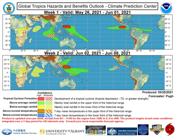

Favored areas of above and below average precipitation are based largely on a consensus between the CFS, GFS, and ECMWF models, MJO precipitation composites for phases 6 and 7, and predicted tracks of tropical cyclones. For hazardous weather concerns during the upcoming two weeks across the U.S. please refer to your local NWS Forecast Office, the Weather Prediction Center's Medium Range Hazards Forecast, and CPC's Week-2 U.S. Hazards Outlook. Forecasts over Africa are made in consultation with the International Desk at CPC and can represent local-scale conditions in addition to global-scale variability.
Rédigé par PATRICK HOAREAU le Tuesday, May 25th 2021 à 23:15