CLICK ON THE IMAGERIES BELOW TO GET THEM ENLARGED
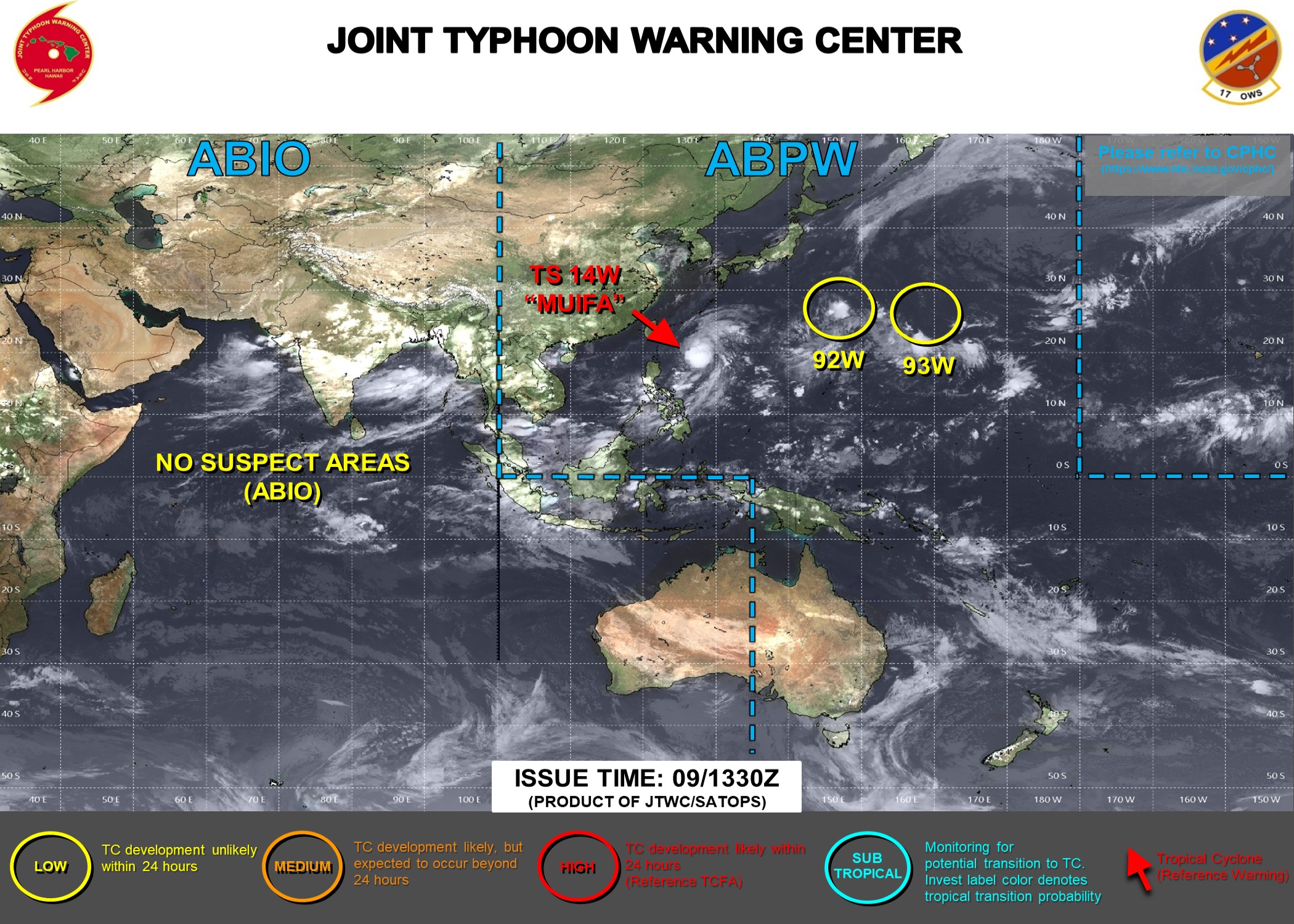
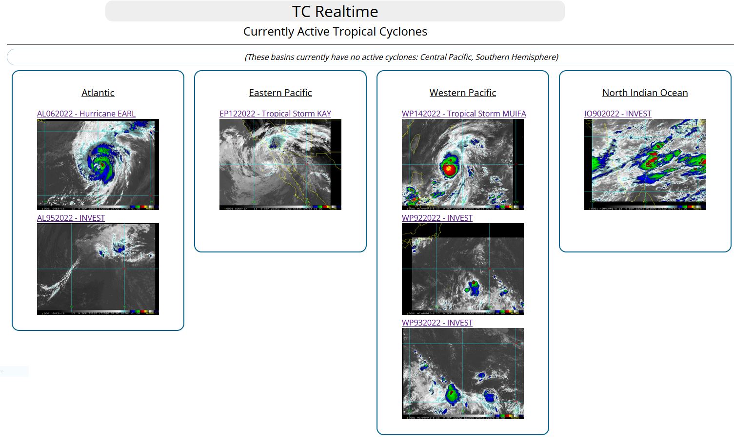
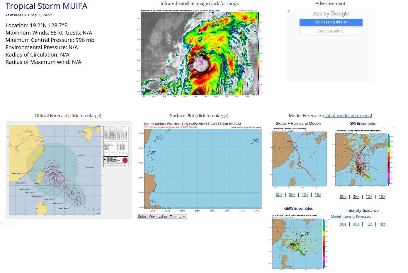
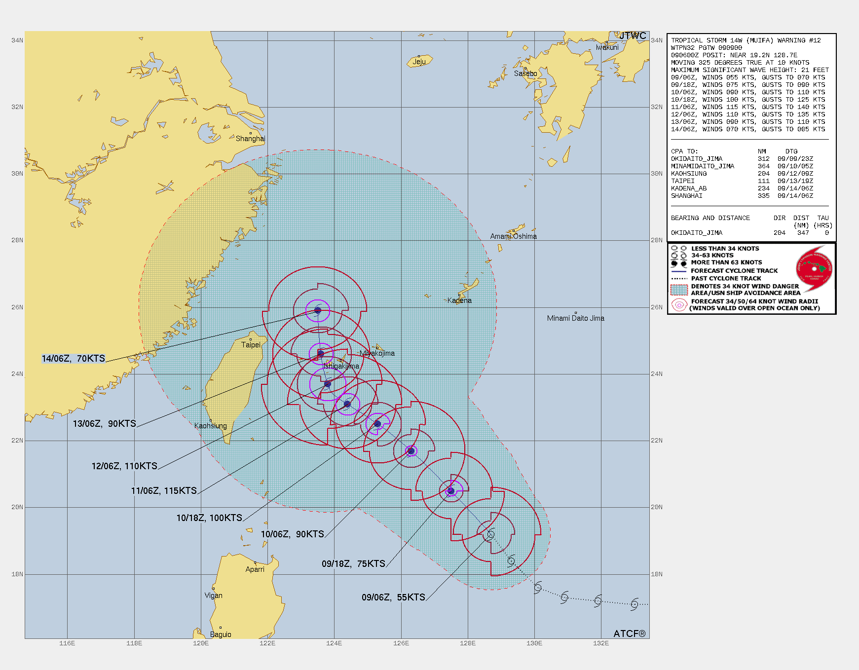
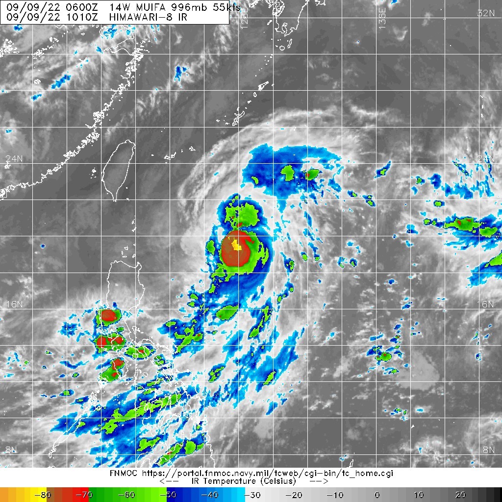
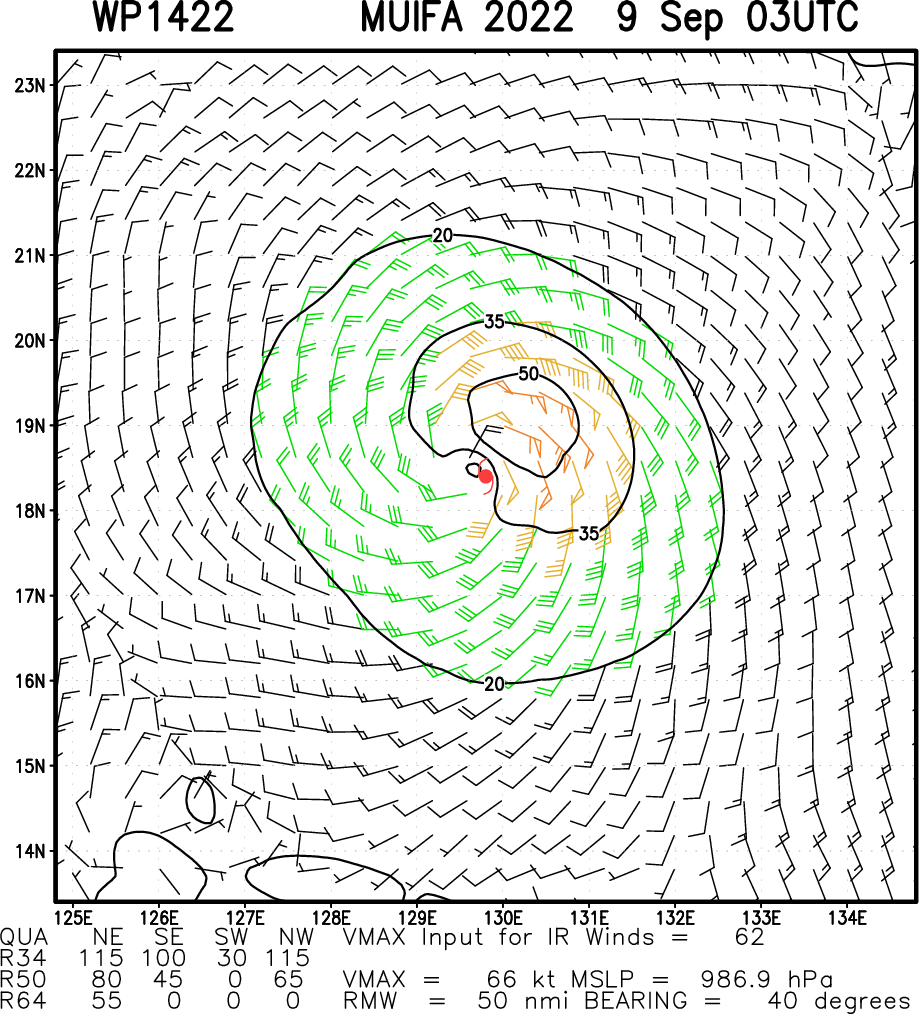
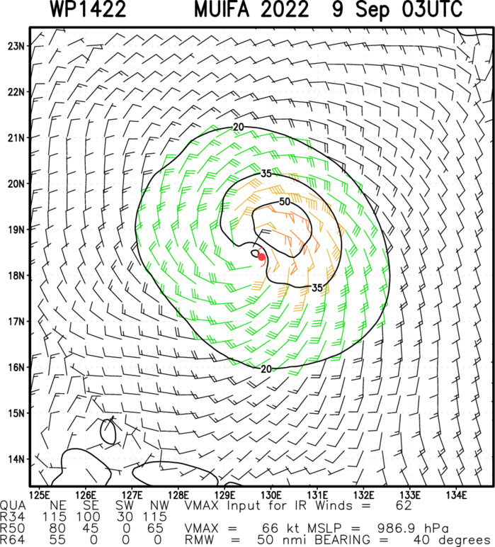
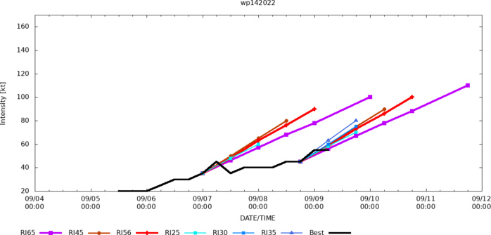
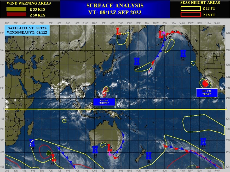
WESTERN NORTH PACIFIC: TS 14W(MUIFA). ESTIMATED LOCATION AND INTENSITY AT 09/06UTC. WARNING 12 ISSUED AT 09/09UTC.
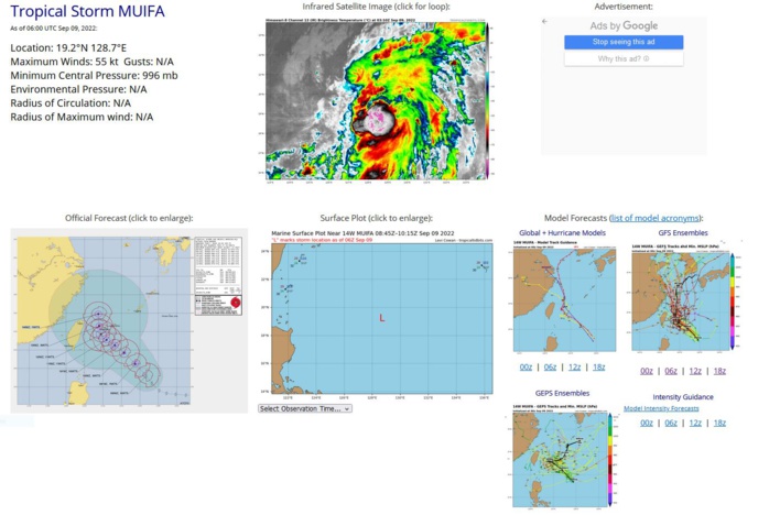
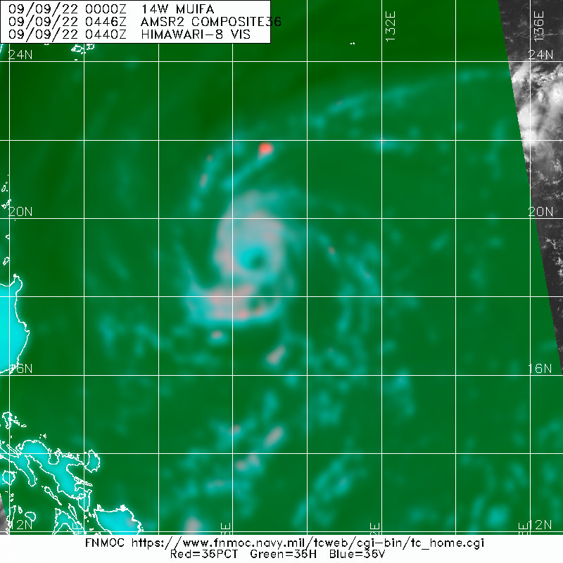
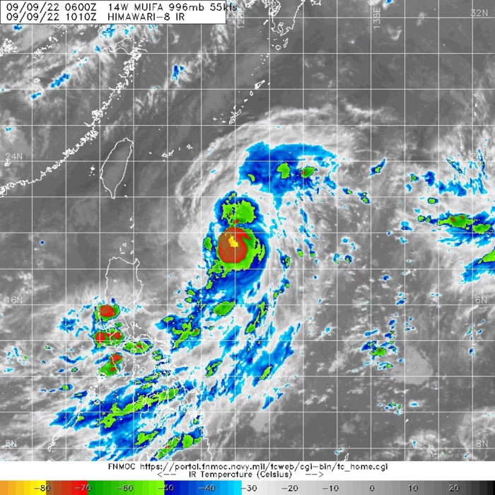
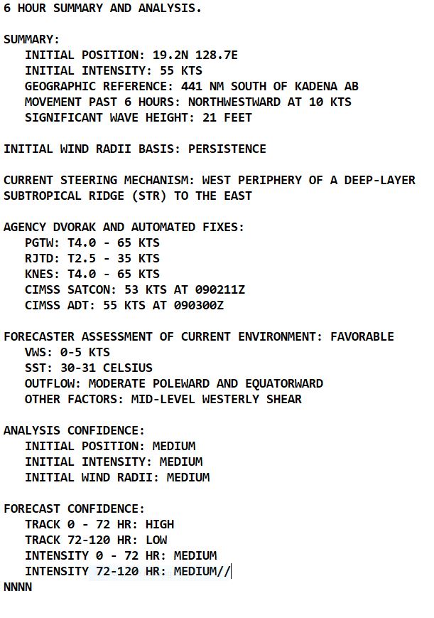
SATELLITE ANALYSIS, INITIAL POSITION AND INTENSITY DISCUSSION: ANIMATED MULTISPECTRAL SATELLITE IMAGERY (MSI) DEPICTS A TIGHT CORE OF CONVECTIVE TOWERS WITH BANDS OF DEEP CONVECTION STRUGGLING TO CONSOLIDATE THE WESTERN FLANK OF THE LLCC. A 090446Z AMSR2 89GHZ MICROWAVE IMAGE SHOWS THAT 14W IS IN-FACT IMPROVING ITS CORE STRUCTURE AND DEVELOPING EYE-LIKE FEATURES WITH INCREASING FREQUENCY. THE INITIAL POSITION IS PLACED WITH MEDIUM CONFIDENCE BASED ON MSI AND AMSR2 IMAGERY. WE ARE STILL SUFFERING A DATA OUTAGE SOMEWHERE UPSTREAM, AND AS A RESULT OBJECTIVE FIX DATA IS NOT CONSISTENT AND CIMSS SHEAR ANALYSIS IS UNAVAILABLE DUE TO THE OUTAGE, AS A RESULT ENVIRONMENTAL ASSESSMENT IS LARGELY BASED ON MODEL DERIVED VALUES, AND IS FAIRLY LOW CONFIDENCE. BASED ON AGENCY DVORAK INTENSITY ESTIMATES INDICATING A RANGE FROM 42-65 KTS AND A SLIGHTLY OLDER SIMSS ADT SHOWING 55 KTS, THE INITIAL INTENSITY OF 55 KTS IS ASSESSED WITH MEDIUM CONFIDENCE.
WP, 14, 2022090800,171N, 1330E, 40,1002
WP, 14, 2022090806,172N, 1319E, 40,1002
WP, 14, 2022090812,173N, 1309E, 45,1000
WP, 14, 2022090818,176N, 1301E, 45,1000
WP, 14, 2022090900,184N, 1293E, 55, 996
WP, 14, 2022090906,192N, 1287E, 55, 996
WP, 14, 2022090912,195N, 1279E, 60, 993
WP, 14, 2022090806,172N, 1319E, 40,1002
WP, 14, 2022090812,173N, 1309E, 45,1000
WP, 14, 2022090818,176N, 1301E, 45,1000
WP, 14, 2022090900,184N, 1293E, 55, 996
WP, 14, 2022090906,192N, 1287E, 55, 996
WP, 14, 2022090912,195N, 1279E, 60, 993
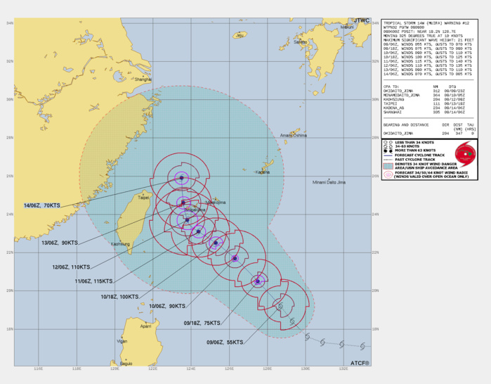
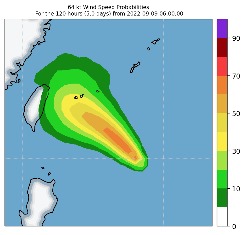
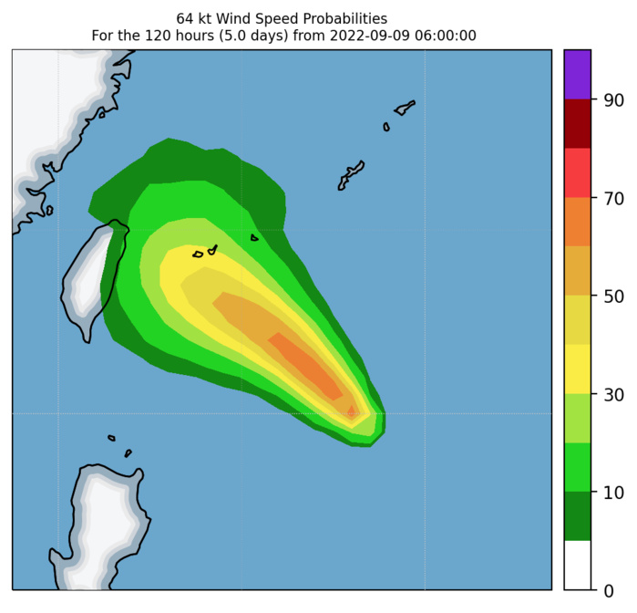
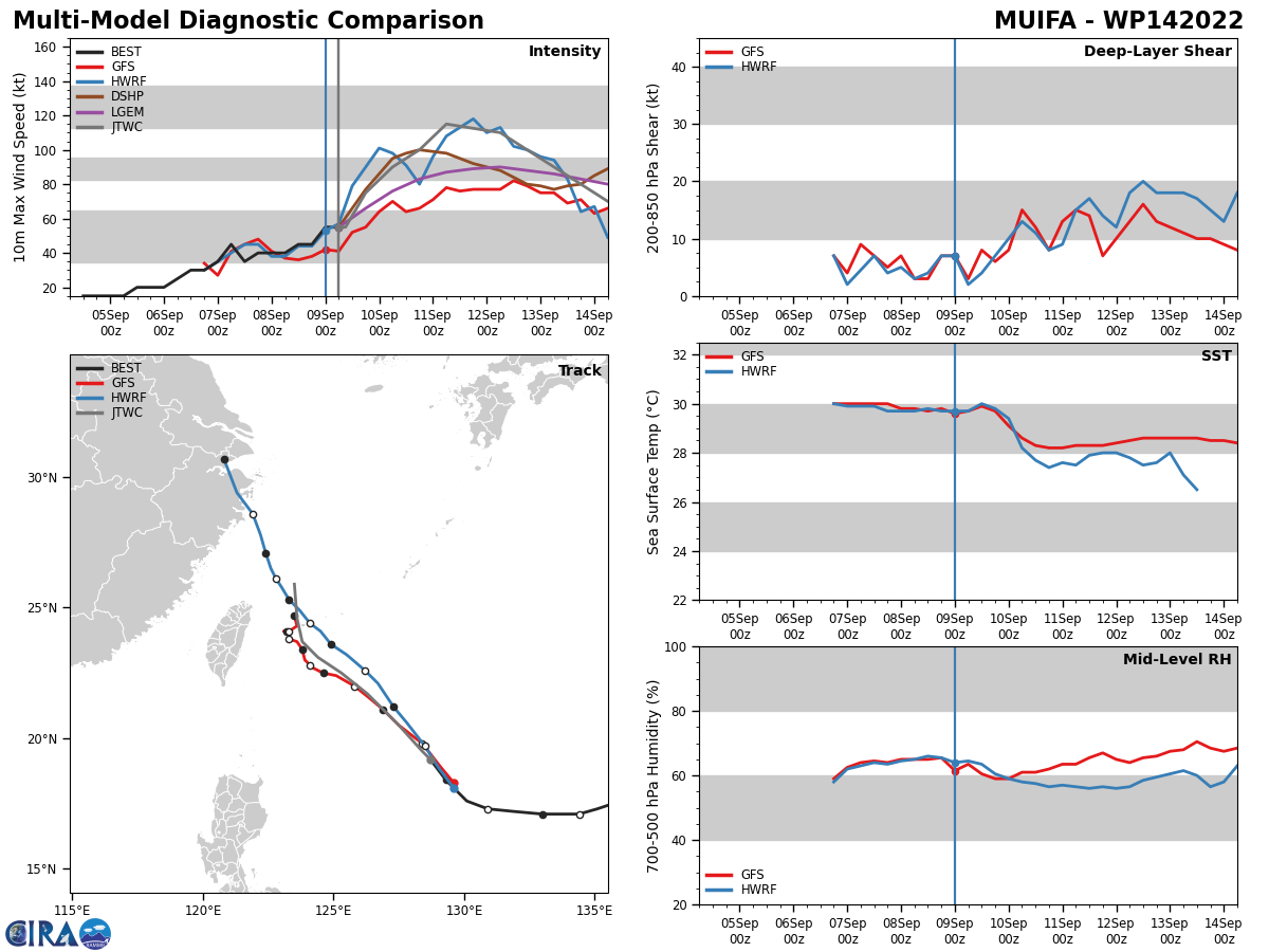
FORECAST REASONING. SIGNIFICANT FORECAST CHANGES: THERE ARE NO SIGNIFICANT CHANGES TO THE FORECAST FROM THE PREVIOUS WARNING. FORECAST DISCUSSION: TS 14W CONTINUES TO TRACK NORTHWESTWARD UNDER THE STEERING INFLUENCE OF THE STR TO THE EAST. WE HAVE ALREADY SEEN INTERMITTENT SIGNS OF EYE-LIKE FORMATION AND OVER THE NEXT 12 HOURS THE SYSTEM WILL CONTINUE TO DEVELOP, FORM AND MAINTAIN AN EYE AS IT REACHES TYPHOON STRENGTH. ANIMATED UPPER LEVEL WATER VAPOR IMAGERY INDICATES THAT A TROPICAL UPPER TROPOSPHERE TROUGH (TUTT) HAS BEEN SUPPRESSING CONVECTION ON THE WESTERN SIDE OF 14W, BUT AS THIS FEATURE CONTINUES TO MOVE WESTWARD OVER THE COMING HOURS, THE SYSTEM WILL BE FREE TO FULLY DEVELOP. AS THE SYSTEM CONTINUES TO INTENSIFY TO A POSSIBLE PEAK OF 115 KTS BY TAU 48, THE STEERING FLOW SURROUNDING THE SYSTEM BECOMES EERILY SIMILAR TO 12W AND WITH A SIMILAR RESULT. A NEAR EQUATORIAL RIDGE (NER) WILL SET UP TO THE SOUTH, A STR WILL BAR THE PATH TO THE NORTHEAST AND ANOTHER STR WILL PREVENT ESCAPE TO THE NORTHWEST, AS THIS SETS UP, TRACK SPEEDS WILL SLOW CONSIDERABLY THROUGH TAU 72. THERE REMAINS A SIZABLE OHC COLD POOL EAST OF TAIWAN THAT WILL CAUSE SIGNIFICANT WEAKENING AS THE SYSTEM PASSES OVER IT. AS A RESULT, DOWN TRACK INTENSITY WILL HAVE AN INVERSE RELATIONSHIP TO THE DURATION OF TIME THE SYSTEMS IS IN THIS COLD POOL. THEREFOR, BY TAU 96, AS THE SYSTEM FINALLY REGAINS NORTHWARD PROGRESSION THANKS TO A PASSING MID LATITUDE TROUGH, 14W WILL BE ON A WEAKENING TREND. AS THE SYSTEM CONTINUES INTO THE EAST CHINA SEA BY TAU 120, IT WILL HAVE LOST A SIGNIFICANT PORTION OF ITS INTENSITY, BUT WILL LIKELY STILL BE A TYPHOON STRENGTH TROPICAL CYCLONE.
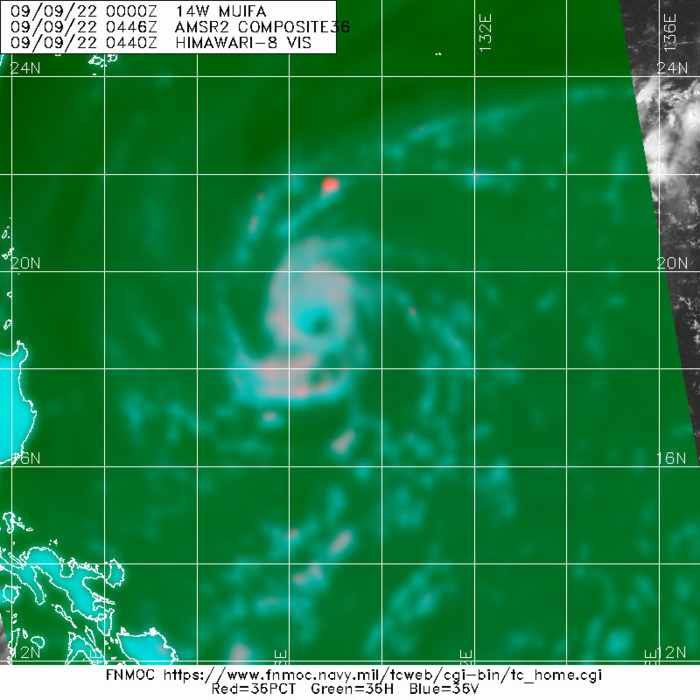
AMSR2 89GHZ MICROWAVE IMAGE SHOWS THAT 14W IS IN-FACT IMPROVING ITS CORE STRUCTURE AND DEVELOPING EYE-LIKE FEATURES WITH INCREASING FREQUENCY.
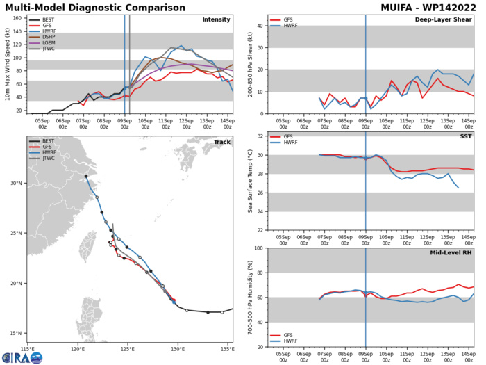
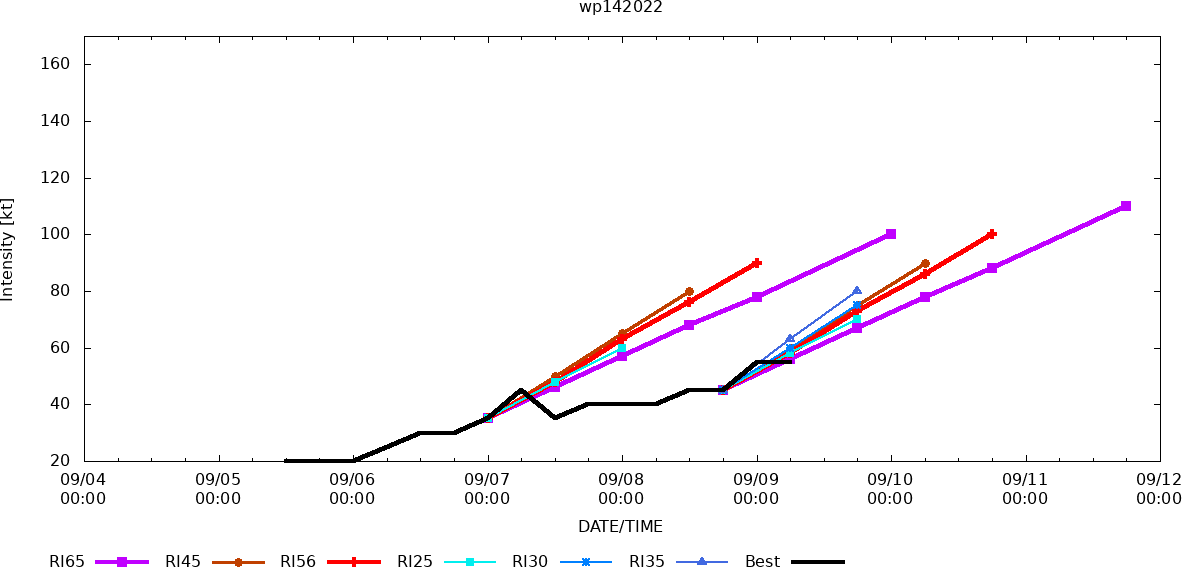
MODEL DISCUSSION: NUMERICAL MODEL CROSS TRACK AGREEMENT REMAINS SOLID THROUGH TAU 72, HOWEVER, AS DISCUSSED ABOVE THE COMPETING STEERING ENVIRONMENT CREATES SIGNIFICANT ALONG TRACK DISCREPANCIES AFTER TAU 48, AS VARIOUS MODELS TRY TO RESOLVE THE STEERING FLOW. FOR THIS REASON, THE INITIAL JTWC FORECAST TRACK IS PLACED WITH HIGH CONFIDENCE, AND THE EXTENDED TRACK FORECAST IS PLACED WITH LOW CONFIDENCE. RELIABLE MODEL INTENSITY GUIDANCE IS IN GOOD AGREEMENT WITH ALL MEMBERS SHOWING RAPID INTENSIFICATION (RI) THROUGH TAU 36 - TAU 48 AFTER WHICH INTENSITIES STAGNATE AND EVENTUALLY FALL THROUGHOUT THE REMAINING FORECAST PERIOD. WHILE THE GENERAL INTENSITY TREND REMAINS CONSISTENT, THE EXTENT OF THE INITIAL RI PHASE IS NOT, THE MAIN FACTOR INFLUENCING THE MODEL SPREAD IS THE DURATION AND SOUTHWARD EXTENT THE SYSTEM IS QS OFF THE COAST OF TAIWAN. FOR THESE REASONS THE JTWC INTENSITY FORECAST IS PLACED WITH MEDIUM CONFIDENCE.
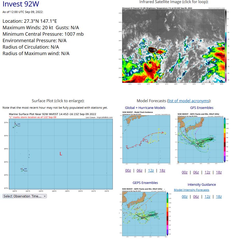
WESTERN NORTH PACIFIC: INVEST 92W. ESTIMATED LOCATION AND INTENSITY AT 09/12UTC. ADVISORY(ABPW) ISSUED AT 09/1330UTC.
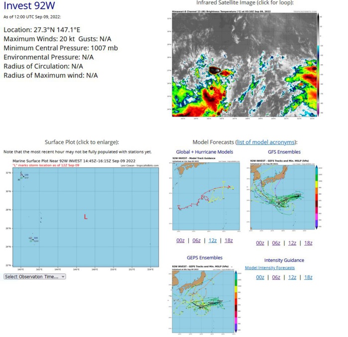
AN AREA OF CONVECTION (INVEST 92W) HAS PERSISTED NEAR 27.2N 147E, APPROXIMATELY 630 NM SOUTHEAST OF TOKYO, JAPAN. ANIMATED INFRARED SATELLITE IMAGERY AND A 091053Z ASCAT-B PASS DEPICTS A FULLY OBSCURED LOW LEVEL CIRCULATION WITH FLARING CONVECTION DIRECTLY OVERHEAD AND 20 KNOT WINDS TO THE SOUTH EAST. HIMAWARI-8 090300Z ENVIRONMENTAL ANALYSIS SHOWS 92W IS IN A LOW (10-15 KNOTS) VERTICAL WIND SHEAR ENVIRONMENT WITH GOOD EQUATORIAL OUTFLOW, BOTH FAVORABLE FOR DEVELOPMENT. GLOBAL MODELS ARE IN GENERALLY GOOD AGREEMENT THAT 92W WILL GRADUALLY CONSOLIDATE AND INTENSIFY TRACKING WEST OVER THE NEXT FEW DAYS. SEA SURFACE TEMPERATURES ARE 29-30C, MAXIMUM SUSTAINED SURFACE WINDS ARE ESTIMATED AT 15 TO 20 KNOTS. MINIMUM SEA LEVEL PRESSURE IS ESTIMATED TO BE NEAR 1007 MB. THE POTENTIAL FOR THE DEVELOPMENT OF A SIGNIFICANT TROPICAL CYCLONE WITHIN THE NEXT 24 HOURS IS LOW.
WP, 92, 2022090800,243N, 1425E, 15,1008
WP, 92, 2022090806,250N, 1428E, 15,1009
WP, 92, 2022090812,255N, 1430E, 15,1010
WP, 92, 2022090818,261N, 1435E, 15,1010
WP, 92, 2022090900,268N, 1445E, 20,1010
WP, 92, 2022090906,271N, 1457E, 20,1007
WP, 92, 2022090912,273N, 1471E, 20,1007
WP, 92, 2022090806,250N, 1428E, 15,1009
WP, 92, 2022090812,255N, 1430E, 15,1010
WP, 92, 2022090818,261N, 1435E, 15,1010
WP, 92, 2022090900,268N, 1445E, 20,1010
WP, 92, 2022090906,271N, 1457E, 20,1007
WP, 92, 2022090912,273N, 1471E, 20,1007
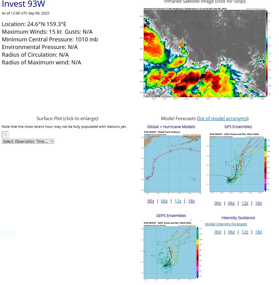
WESTERN NORTH PACIFIC: INVEST 93W. ESTIMATED LOCATION AND INTENSITY AT 09/12UTC. ADVISORY(ABPW) ISSUED AT 09/1330UTC.
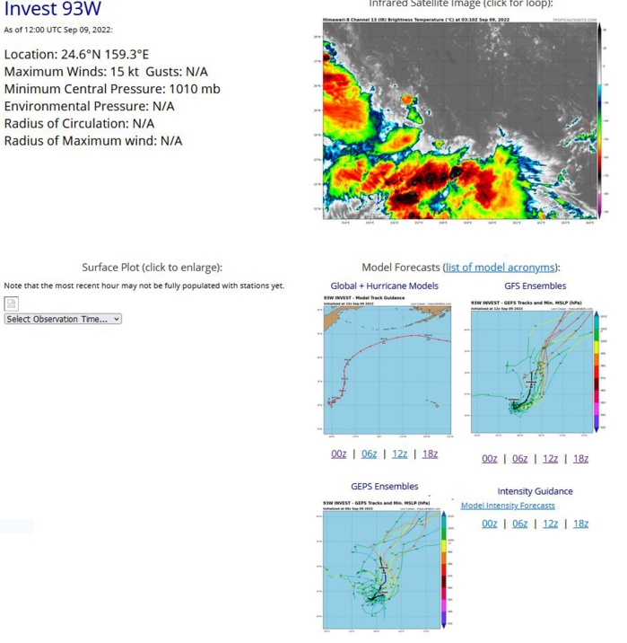
AN AREA OF CONVECTION (INVEST 93W) HAS PERSISTED NEAR 24.7N 159.6E, APPROXIMATELY 343 NM SOUTHEAST OF WAKE ISLAND. ANIMATED INFRARED SATELLITE IMAGERY SHOW A FULLY EXPOSED LOW LEVEL CIRCULATION TRACKING TO THE WEST. HIMAWARI-8 090300Z ENVIRONMENTAL ANALYSIS SHOWS 93W IS IN A LOW (10-15 KNOTS) VERTICAL WIND SHEAR ENVIRONMENT WITH GOOD EQUATORIAL OUTFLOW, BOTH FAVORABLE FOR DEVELOPMENT. GLOBAL MODELS ARE ALL IN AGREEMENT THAT 93W WILL TRACK NORTH AND DEVELOP OVER THE NEXT SEVERAL DAYS. SEA SURFACE TEMPERATURES ARE 28-29C, MAXIMUM SUSTAINED SURFACE WINDS ARE ESTIMATED AT 10 TO 15 KNOTS. MINIMUM SEA LEVEL PRESSURE IS ESTIMATED TO BE NEAR 1010 MB. THE POTENTIAL FOR THE DEVELOPMENT OF A SIGNIFICANT TROPICAL CYCLONE WITHIN THE NEXT 24 HOURS IS LOW.
WP, 93, 2022090806,241N, 1633E, 15 1010
WP, 93, 2022090812,243N, 1629E, 15,1010
WP, 93, 2022090818,245N, 1623E, 15,1010
WP, 93, 2022090900,247N, 1618E, 15,1010
WP, 93, 2022090906,251N, 1610E, 15,1009
WP, 93, 2022090912,246N, 1593E, 15,1010
WP, 93, 2022090812,243N, 1629E, 15,1010
WP, 93, 2022090818,245N, 1623E, 15,1010
WP, 93, 2022090900,247N, 1618E, 15,1010
WP, 93, 2022090906,251N, 1610E, 15,1009
WP, 93, 2022090912,246N, 1593E, 15,1010
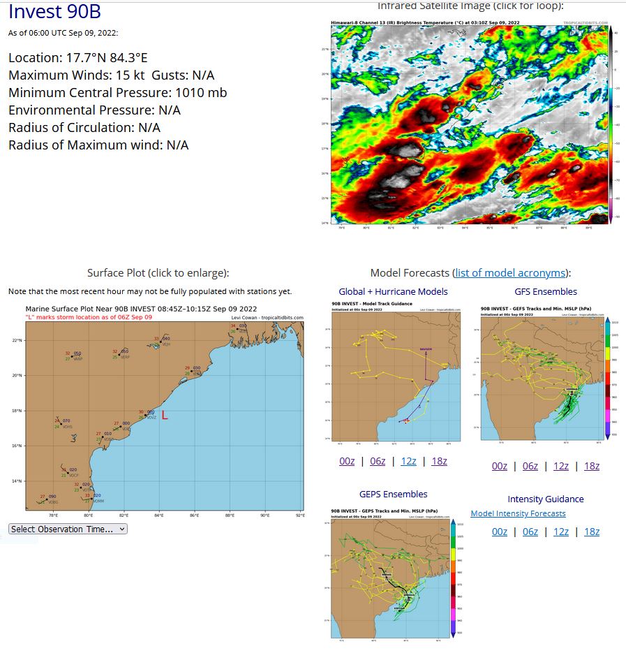
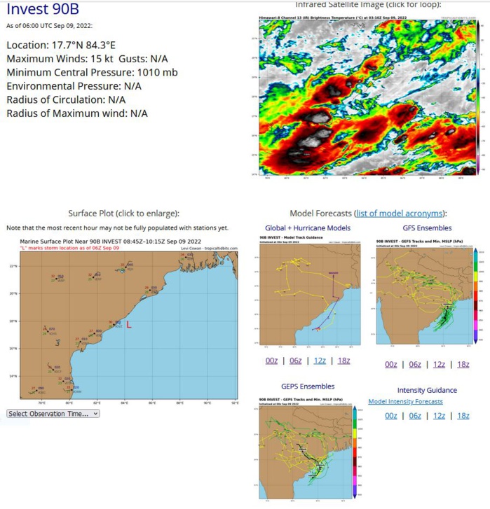
NORTH INDIAN/BAY OF BENGAL: INVEST 90B. ESTIMATED LOCATION AND INTENSITY AT 09/06UTC.
IO, 90, 2022090700,140N, 905E, 20,1002
IO, 90, 2022090706,149N, 899E, 20,1002
IO, 90, 2022090712,154N, 897E, 20,1007
IO, 90, 2022090718,157N, 893E, 15,1006
IO, 90, 2022090800,161N, 880E, 15,1004
IO, 90, 2022090806,163N, 868E, 15,1010
IO, 90, 2022090812,165N, 857E, 15,1010
IO, 90, 2022090818,167N, 848E, 15,1004
IO, 90, 2022090900,171N, 838E, 15,1003
IO, 90, 2022090906,177N, 843E, 15,1010
IO, 90, 2022090912,178N, 847E, 15,1010
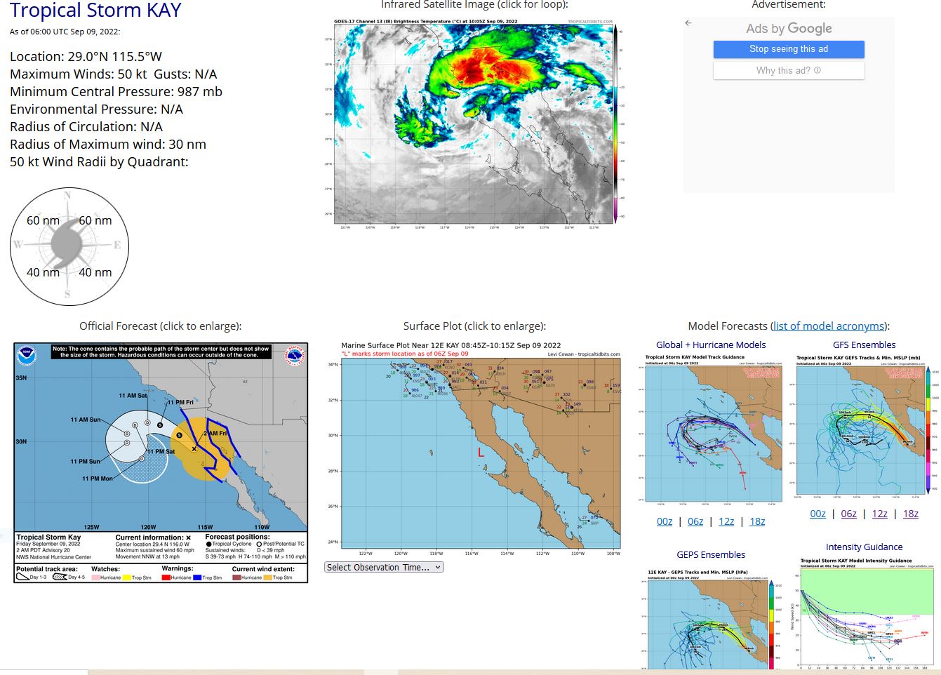
EASTERN NORTH PACIFIC: TS 12E(KAY). ESTIMATED LOCATION AND INTENSITY AT 09/06UTC.
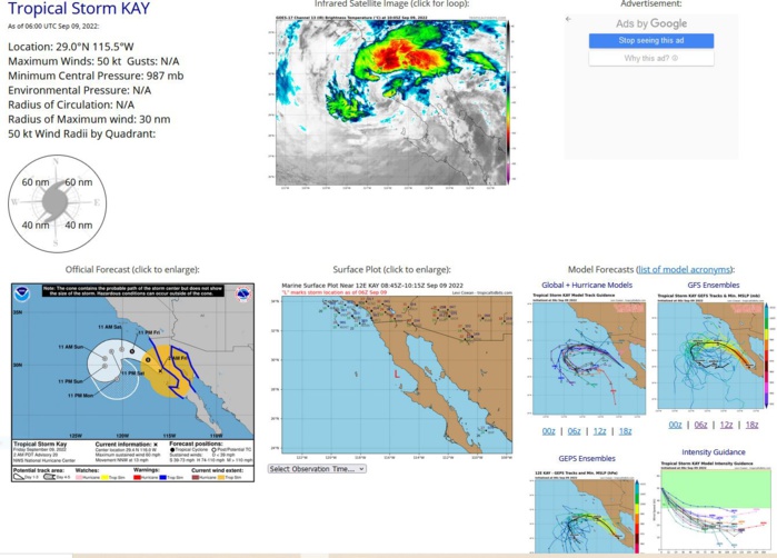
000 WTPZ42 KNHC 090854 TCDEP2 Tropical Storm Kay Discussion Number 20 NWS National Hurricane Center Miami FL EP122022 200 AM PDT Fri Sep 09 2022 After moving back offshore yesterday evening, Kay has been roughly paralleling the northwestern coastline of the Baja California peninsula. The satellite presentation is not all that impressive, with the majority of the deep convective activity firing over the warm waters of the Gulf of California and adjacent mountainous terrain, well removed from Kay's center. An Air Force Reserve Hurricane Hunter aircraft was able to reach the center earlier this morning, and found that Kay's circulation is largely intact, with peak 700-mb flight-level winds of 62 kt and a minimum central pressure of 990 mb. While the standard wind reduction at that flight level would still typically support 55 kt, the SFMR-derived winds in that area were much lower, which better match a dropsonde also launched in the area. South of the center, there were some significant winds observed, with a sustained wind of 44 kt at Isla Cedros at 0630 UTC. Based on a combination of all these data, the initial intensity was reduced to 50 kt for this advisory. Additional weakening over the next 24-36 hours is expected as Kay will be traversing sub-23 C sea-surface temperatures and approaching even cooler waters in the cold California Current. The GFS, ECMWF, and HWRF models all indicate that Kay will cease to produce organized deep convection near its center in about 36 hours, marking its transition to a post-tropical remnant low off the coast of Southern California. The low should spin down further and dissipate sometime in the 4-5 day forecast. The latest NHC intensity forecast is in good agreement with the intensity guidance suite. From the two recon fixes, Kay continues to move off to the north-northwest at 330/11 kt. A narrowing mid-level ridge draped along the northeast side of the storm is expected to maintain this motion with a gradual turn to the northwest and west-northwest today into tonight. As Kay loses its remaining deep convection and becomes more shallow, the weak low-level ridging in the Eastern Pacific should result in the remnant low making a slow cyclonic turn away from the western U.S. coastline. The latest track guidance has shifted a bit more leftward this cycle, and the latest NHC track forecast was also shifted in that direction, towards the track consensus aids. Although Kay's maximum sustained winds are lower, the tropical cyclone 34-kt wind radii remain quite large on its eastern side, as seen in recent scatterometer data showing these tropical-storm-force winds extending up to the northern Gulf of California coast. Wind, surf, and rainfall impacts continue to extend far from the center so users should not focus on the exact forecast track of Kay. KEY MESSAGES: 1. Heavy rainfall could lead to flash flooding, including landslides, across the Baja California peninsula and portions of mainland northwestern Mexico through Saturday morning. Flash, urban, and small stream flooding is likely across Southern California beginning today, especially in and near the peninsular ranges. Flash, urban, and small stream flooding is possible beginning later today in Southwest Arizona. 2. Tropical storm conditions are occurring over portions of the Baja California peninsula, and these conditions extend all the way to the northern Gulf of California coastline, where a Tropical Storm Warning is in effect. 3. Strong winds not directly associated with Kay's core wind field are expected across portions of southern California and extreme southwestern Arizona later today. For information on this wind hazard, users should see High Wind Warnings and other products from their local NWS Weather Forecast Office. FORECAST POSITIONS AND MAX WINDS INIT 09/0900Z 29.4N 116.0W 50 KT 60 MPH 12H 09/1800Z 30.5N 117.3W 40 KT 45 MPH 24H 10/0600Z 31.3N 119.0W 35 KT 40 MPH 36H 10/1800Z 31.5N 120.1W 30 KT 35 MPH...POST-TROP/REMNT LOW 48H 11/0600Z 31.3N 121.2W 25 KT 30 MPH...POST-TROP/REMNT LOW 60H 11/1800Z 30.6N 121.9W 25 KT 30 MPH...POST-TROP/REMNT LOW 72H 12/0600Z 29.9N 121.9W 20 KT 25 MPH...POST-TROP/REMNT LOW 96H 13/0600Z 28.6N 120.6W 20 KT 25 MPH...POST-TROP/REMNT LOW 120H 14/0600Z...DISSIPATED $$ Forecaster Papin
EP, 12, 2022090800,226N, 1129W, 80, 972
EP, 12, 2022090806,239N, 1132W, 75, 972
EP, 12, 2022090812,252N, 1135W, 75, 974
EP, 12, 2022090818,266N, 1141W, 65, 982
EP, 12, 2022090900,279N, 1146W, 55, 985
EP, 12, 2022090906,290N, 1155W, 50, 987
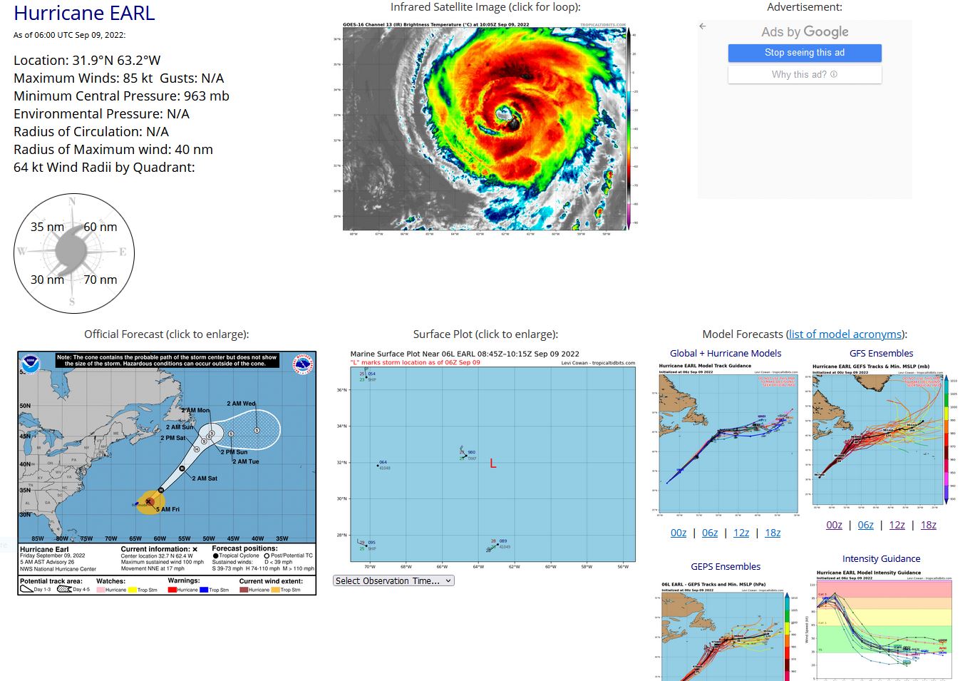
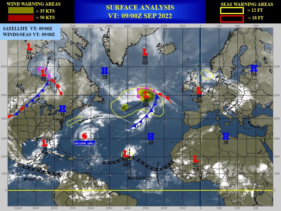
NORTH ATLANTIC: HU 06L(EARL). ESTIMATED LOCATION AND INTENSITY AT 09/06UTC. NHC COMMENTS.
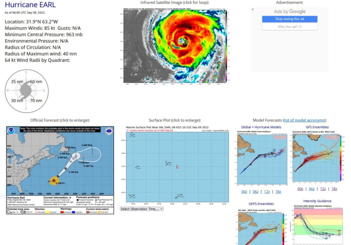
724 WTNT41 KNHC 090847 TCDAT1 Hurricane Earl Discussion Number 26 NWS National Hurricane Center Miami FL AL062022 500 AM AST Fri Sep 09 2022 Radar data from Bermuda and conventional satellite images show that Earl's structure has improved a bit overnight with the eye becoming better defined and the overall cloud envelope looking more symmetric. An Air Force Reserve Hurricane Hunter aircraft measured a peak 700-mb flight-level wind of 97 kt and SFMR winds as high as 77 kt, with the central pressure down slightly to 963 mb. Based on the typical reduction of the flight-level winds, and accounting for undersampling of the surface winds, Earl's initial intensity is raised back to 85 kt. Reconnaissance and scatterometer data also indicate that Earl's wind field has continued to expand. Earl is accelerating toward the north-northeast (030 degrees at 15 kt) ahead of a shortwave trough approaching from the west near the New England coast. The hurricane is forecast to turn northeastward today and continue accelerating to speeds of 25-30 kt within 24 hours. After that time, however, Earl will merge with the aforementioned trough, slowing down considerably to speeds of around 5 kt to the southeast of Newfoundland in 60-72 hours. By days 4 and 5, the system should then move a little bit faster toward the east, embedded within the mid-latitude westerlies. The track guidance is in generally good agreement for much of the 5-day forecast period, and no significant changes were made to the updated NHC track forecast. Earl will remain over warm waters for another 24 hours or so, and the deep-layer shear should be low to moderate during the next 6 to 12 hours. As a result, some additional strengthening is anticipated through tonight, and the NHC intensity forecast is near the IVCN consensus during that period. A few models, including SHIPS, LGEM, and HCCA, still bring Earl to major hurricane strength in 24 hours, but given that the cyclone will be starting to undergo extratropical transition by then, that scenario is becoming increasingly unlikely (although not impossible). Global model fields indicate that Earl should complete the transition to a powerful extratropical low by 36 hours and then gradually weaken through the remainder of the forecast period. During the extratropical phase, the NHC intensity forecast is closest to the GFS solution. KEY MESSAGES: 1. Tropical storm conditions are expected to diminish on Bermuda later this morning. 2. Swells generated by Earl are affecting Bermuda and the U.S. East Coast and are expected to reach Nova Scotia and Newfoundland tonight and on Saturday. These swells are likely to cause life-threatening surf and rip current conditions through the weekend. Please consult products from your local weather office. FORECAST POSITIONS AND MAX WINDS INIT 09/0900Z 32.7N 62.4W 85 KT 100 MPH 12H 09/1800Z 35.0N 59.8W 90 KT 105 MPH 24H 10/0600Z 39.2N 55.5W 95 KT 110 MPH 36H 10/1800Z 42.7N 52.5W 80 KT 90 MPH...POST-TROP/EXTRATROP 48H 11/0600Z 44.1N 51.0W 60 KT 70 MPH...POST-TROP/EXTRATROP 60H 11/1800Z 44.9N 50.0W 50 KT 60 MPH...POST-TROP/EXTRATROP 72H 12/0600Z 45.5N 49.4W 45 KT 50 MPH...POST-TROP/EXTRATROP 96H 13/0600Z 45.4N 45.5W 35 KT 40 MPH...POST-TROP/EXTRATROP 120H 14/0600Z 46.0N 40.2W 35 KT 40 MPH...POST-TROP/EXTRATROP $$ Forecaster Berg
AL, 06, 2022090800,268N, 655W, 80, 971
AL, 06, 2022090806,277N, 655W, 90, 969
AL, 06, 2022090812,286N, 653W, 90, 962
AL, 06, 2022090818,297N, 647W, 90, 964
AL, 06, 2022090900,306N, 643W, 85, 964
AL, 06, 2022090906,319N, 632W, 85, 963
AL, 06, 2022090806,277N, 655W, 90, 969
AL, 06, 2022090812,286N, 653W, 90, 962
AL, 06, 2022090818,297N, 647W, 90, 964
AL, 06, 2022090900,306N, 643W, 85, 964
AL, 06, 2022090906,319N, 632W, 85, 963
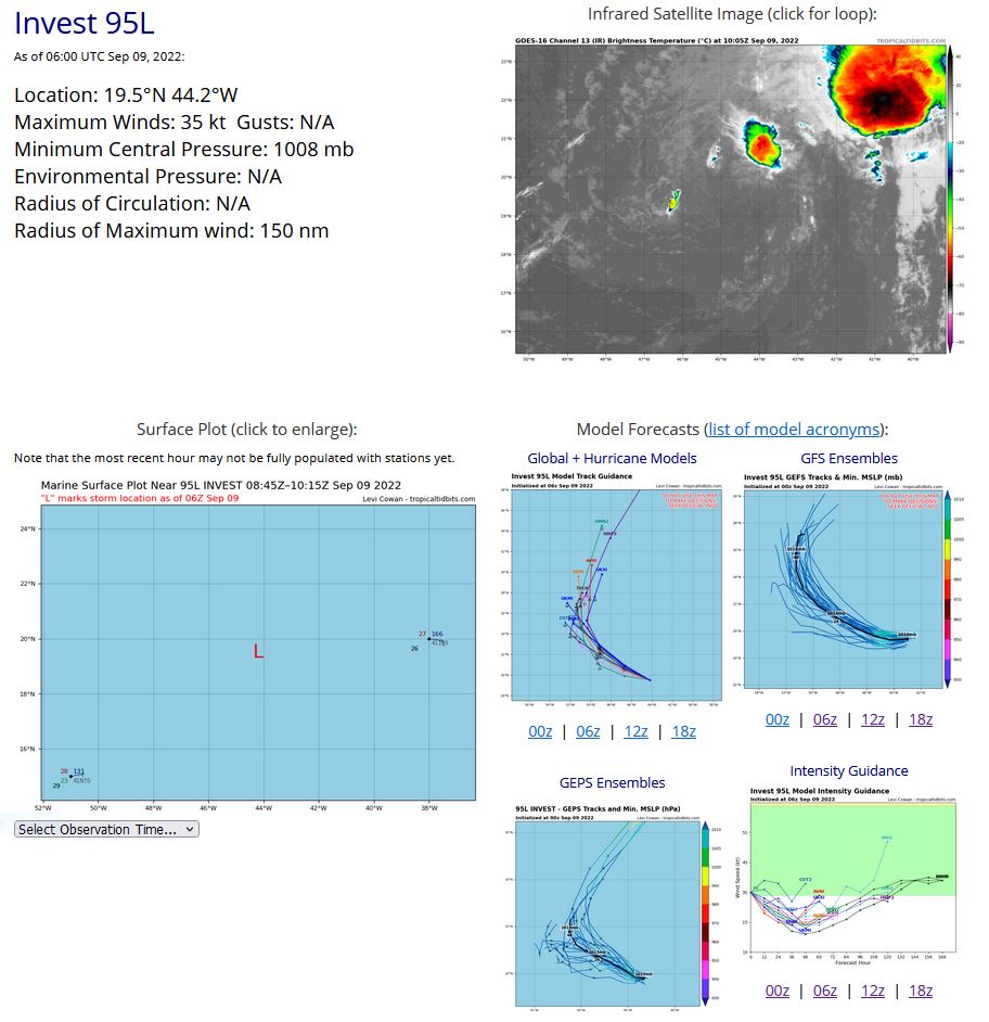
NORTH ATLANTIC: INVEST 95L. ESTIMATED LOCATION AND INTENSITY AT 09/06UTC. NHC COMMENTS.
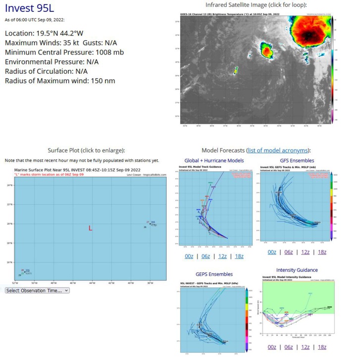
ZCZC MIATWOAT ALL TTAA00 KNHC DDHHMM Tropical Weather Outlook NWS National Hurricane Center Miami FL 200 AM EDT Fri Sep 9 2022 For the North Atlantic...Caribbean Sea and the Gulf of Mexico: Active Systems: The National Hurricane Center is issuing advisories on Hurricane Earl, located about 100 miles southeast of Bermuda. 1. Central Tropical Atlantic: A gale-force low pressure system located about 1200 miles east of the Leeward Islands continues to produce disorganized showers and thunderstorms that are displaced well to the northeast of the circulation center due to strong upper-level winds. Although the upper-level winds are expected to remain strong, the low still has some opportunity during the next day or so to become a short-lived tropical cyclone while moving toward the west-northwest at about 15 mph into the central subtropical Atlantic. For more information on this system, including gale warnings, please refer to the High Seas Forecasts issued by the National Weather Service. * Formation chance through 48 hours...medium...40 percent. * Formation chance through 5 days...medium...40 percent.
AL, 95, 2022090518,132N, 220W, 20,1012
AL, 95, 2022090600,132N, 234W, 20,1012
AL, 95, 2022090606,133N, 247W, 20,1012
AL, 95, 2022090612,138N, 261W, 20,1012
AL, 95, 2022090618,138N, 276W, 25,1012
AL, 95, 2022090700,145N, 305W, 25,1012
AL, 95, 2022090706,152N, 326W, 30,1010
AL, 95, 2022090712,161N, 347W, 30,1009
AL, 95, 2022090718,168N, 363W, 30,1009
AL, 95, 2022090800,175N, 377W, 30,1009
AL, 95, 2022090806,182N, 391W, 30,1009
AL, 95, 2022090812,193N, 405W, 35,1007
AL, 95, 2022090818,198N, 420W, 40,1004
AL, 95, 2022090900,196N, 434W, 35,1008
AL, 95, 2022090906,195N, 442W, 35,1008
