

CLICK ON THE IMAGERIES BELOW TO GET THEM ENLARGED

JTWC PH
JTWC FACEBOOK
Joint Typhoon Warning Center
National Hurricane Center
GTH Outlook Discussion
Last Updated - 09/15/26
Valid - 09/23/26 - 10/06/26
Over the past week, the Madden Julian Oscillation (MJO) has remained weak as the low-frequency El Nino base state has continued to dominate the global tropical convective signal. In RMM-space, the MJO index entered the unit circle over the far Western Pacific before propagating eastward through the Western Hemisphere and into the Indian Ocean. Further evidence of this weak signal is apparent in a small pocket of anomalous 200-hPa velocity potential (VP) divergence over the Indian Ocean.
As the MJO continues propagating eastward, two distinct intraseasonal signals are emerging in the models. The weaker signal continues moving eastward into the Maritime Continent, visible in the upper-level VP anomalies and MJO spectral filtering, while a stronger, secondary signal appears in the RMM-index. The ECMWF tracks this stronger signal propagating through the Western Hemisphere and back into the Indian Ocean. In contrast, the GEFS exhibits extremely high ensemble spread, resulting in a weak signal that does attempt to propagate through the Western Hemisphere but remains meandering there through Week-3. Despite these differences, both dynamical models shift the primary convective envelope eastward into the Atlantic by Week-2, aligned with the stronger intraseasonal signal. By Week-3, the convective envelope begins to be influenced by the weaker signal to the west as it moves into the Western Pacific and constructively interferes with the El Nino base state.
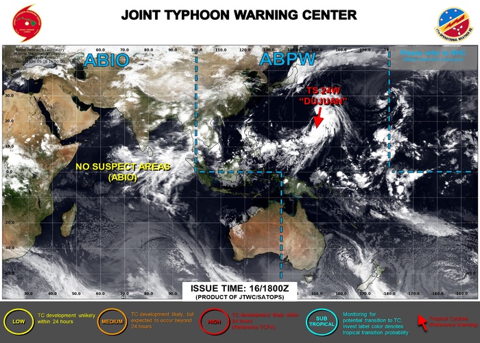
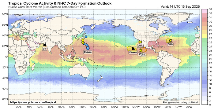
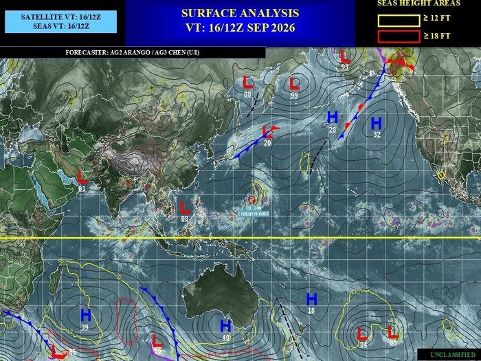
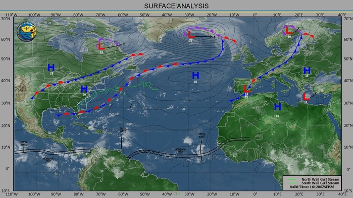
Over the past week, two tropical cyclones (TCs) formed in the Eastern Pacific Ocean. TC Norbert formed as a tropical depression (TD) on 9/9 at 16N / 115W and tracked westward as it gained tropical storm strength becoming post-tropical today over the Central Pacific. TD Fifteen formed on 9/13 at 17N /117W and has also been tracking westward. It is no longer expected to reach tropical storm strength and should dissipate over the next few days. In the Western Pacific, TC 24W formed on 9/15 northeast of Guam and is expected to track northward before taking a northwesterly turn towards Japan.
Over the next week, the National Hurricane Center (NHC) is monitoring an area in the open Atlantic centered near 30N / 60W for possible cyclogenesis, highlighting a 40% chance of formation. The NHC is also monitoring an area in the Eastern Pacific southwest of Mexico centered around 13N / 105W with a 30% chance of development. Also, as the second active period of the Northern Indian Ocean cyclone season begins, there is a possibility for activity in the Bay of Bengal during the next week. For further updates on active systems and possible Week-1 development, please refer to the JTWC at https://www.metoc.navy.mil/jtwc/jtwc.html and the NHC at https://www.nhc.noaa.gov/.
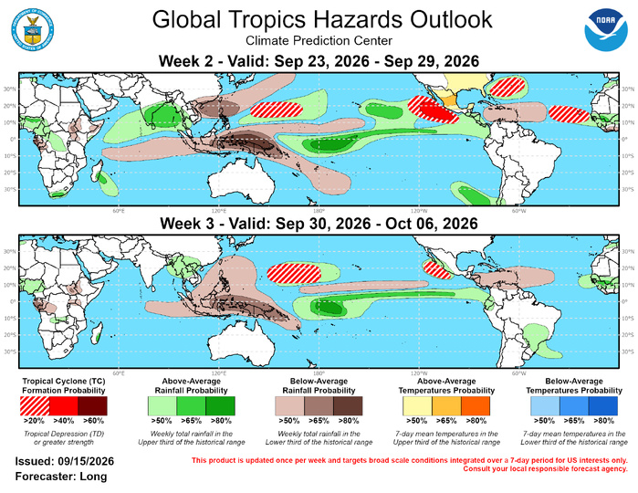
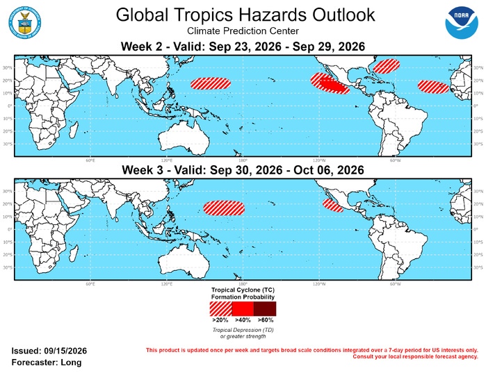
With the primary convective envelope moving over the Atlantic Ocean, MJO composites favor cyclogenesis off the coast of Africa in the eastern Main Development Region (MDR). Dynamical models forecast a relaxation of the intense wind shear seen over the MDR over the past month which may finally present an opportunity for TC development. During the end of September and into October, climatology shows a decrease in TC formations in the MDR as overall conditions become more unfavorable for development. Therefore, although shear will be lowest during Week-3, Week-2 may present the highest chance for cyclogenesis, and a 20-40% chance of formation is posted. In addition, farther west convection north of the Bahamas may help trigger possible TC formation resulting in a 20-40% chance of formation where there is some support in the probabilistic TC tools and ensembles.
As with the Atlantic, the eastward shifting primary convective envelope will provide favorable conditions in the Eastern Pacific, along the coast of Mexico during both Weeks 2 and 3. This is supported by MJO composites and dynamical model support. Chances are greater during Week-2, therefore a 40-60% chance of formation is posted, while during Week-3 a 20-40% chance of formation is posted.
In the Western Pacific, a 20-40% chance of formation is possible in both Weeks 2 and 3. Dynamical models support possible cyclogenesis to the east of Guam in a similar location to TD24 in early Week-2. During Week-3, the likely return of constructive interference with the El Nino base state, as the weaker intraseasonal signal passing through the Maritime Continent and into the Western Pacific, supports formation farther east towards the Dateline.
JTWC FACEBOOK
Joint Typhoon Warning Center
National Hurricane Center
GTH Outlook Discussion
Last Updated - 09/15/26
Valid - 09/23/26 - 10/06/26
Over the past week, the Madden Julian Oscillation (MJO) has remained weak as the low-frequency El Nino base state has continued to dominate the global tropical convective signal. In RMM-space, the MJO index entered the unit circle over the far Western Pacific before propagating eastward through the Western Hemisphere and into the Indian Ocean. Further evidence of this weak signal is apparent in a small pocket of anomalous 200-hPa velocity potential (VP) divergence over the Indian Ocean.
As the MJO continues propagating eastward, two distinct intraseasonal signals are emerging in the models. The weaker signal continues moving eastward into the Maritime Continent, visible in the upper-level VP anomalies and MJO spectral filtering, while a stronger, secondary signal appears in the RMM-index. The ECMWF tracks this stronger signal propagating through the Western Hemisphere and back into the Indian Ocean. In contrast, the GEFS exhibits extremely high ensemble spread, resulting in a weak signal that does attempt to propagate through the Western Hemisphere but remains meandering there through Week-3. Despite these differences, both dynamical models shift the primary convective envelope eastward into the Atlantic by Week-2, aligned with the stronger intraseasonal signal. By Week-3, the convective envelope begins to be influenced by the weaker signal to the west as it moves into the Western Pacific and constructively interferes with the El Nino base state.
Over the past week, two tropical cyclones (TCs) formed in the Eastern Pacific Ocean. TC Norbert formed as a tropical depression (TD) on 9/9 at 16N / 115W and tracked westward as it gained tropical storm strength becoming post-tropical today over the Central Pacific. TD Fifteen formed on 9/13 at 17N /117W and has also been tracking westward. It is no longer expected to reach tropical storm strength and should dissipate over the next few days. In the Western Pacific, TC 24W formed on 9/15 northeast of Guam and is expected to track northward before taking a northwesterly turn towards Japan.
Over the next week, the National Hurricane Center (NHC) is monitoring an area in the open Atlantic centered near 30N / 60W for possible cyclogenesis, highlighting a 40% chance of formation. The NHC is also monitoring an area in the Eastern Pacific southwest of Mexico centered around 13N / 105W with a 30% chance of development. Also, as the second active period of the Northern Indian Ocean cyclone season begins, there is a possibility for activity in the Bay of Bengal during the next week. For further updates on active systems and possible Week-1 development, please refer to the JTWC at https://www.metoc.navy.mil/jtwc/jtwc.html and the NHC at https://www.nhc.noaa.gov/.
With the primary convective envelope moving over the Atlantic Ocean, MJO composites favor cyclogenesis off the coast of Africa in the eastern Main Development Region (MDR). Dynamical models forecast a relaxation of the intense wind shear seen over the MDR over the past month which may finally present an opportunity for TC development. During the end of September and into October, climatology shows a decrease in TC formations in the MDR as overall conditions become more unfavorable for development. Therefore, although shear will be lowest during Week-3, Week-2 may present the highest chance for cyclogenesis, and a 20-40% chance of formation is posted. In addition, farther west convection north of the Bahamas may help trigger possible TC formation resulting in a 20-40% chance of formation where there is some support in the probabilistic TC tools and ensembles.
As with the Atlantic, the eastward shifting primary convective envelope will provide favorable conditions in the Eastern Pacific, along the coast of Mexico during both Weeks 2 and 3. This is supported by MJO composites and dynamical model support. Chances are greater during Week-2, therefore a 40-60% chance of formation is posted, while during Week-3 a 20-40% chance of formation is posted.
In the Western Pacific, a 20-40% chance of formation is possible in both Weeks 2 and 3. Dynamical models support possible cyclogenesis to the east of Guam in a similar location to TD24 in early Week-2. During Week-3, the likely return of constructive interference with the El Nino base state, as the weaker intraseasonal signal passing through the Maritime Continent and into the Western Pacific, supports formation farther east towards the Dateline.

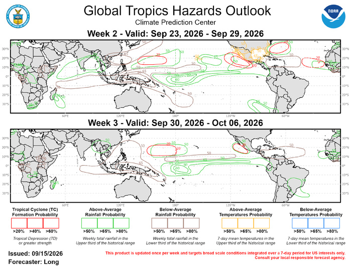
The precipitation outlook for Weeks 2 and 3 is based on the skill weighted consolidated blend of GEFS, CFS, and ECMWF ensemble forecast systems, historical composites during Aug-Oct for MJO phases 1-2, and the low frequency influence associated with El Nino. Below-average rainfall is expected to continue over the southern Indian Ocean into the Maritime Continent, the far western Pacific, and the Caribbean Sea. Above-normal rainfall is expected across the equatorial Pacific due to the continuing El Nino and the Bay of Bengal in association with possible TC activity. Increased chances for above-normal temperatures are expected throughout much of Mexico and the eastern half of the United States during Week-2. Increased chances for above-normal temperatures are also expected for the southern portion of the Hawaii Islands. For hazardous weather conditions in your area during the next two weeks, please refer to your local NWS office, the Medium Range Hazards Forecast from the Weather Prediction Center (WPC), and the CPC Week-2 Hazards Outlook. Forecasts issued over Africa are made in coordination with the International Desk at CPC.