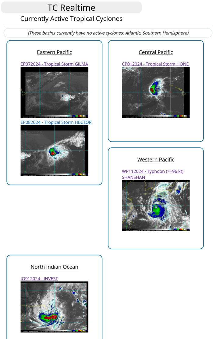
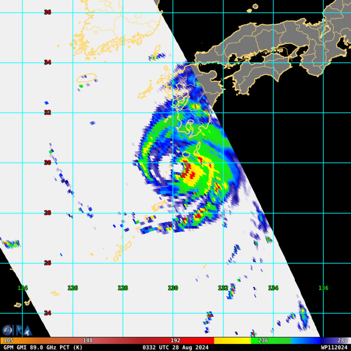
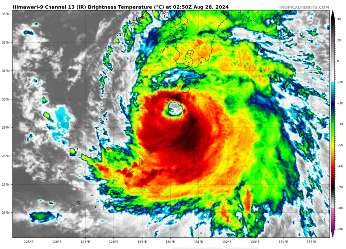
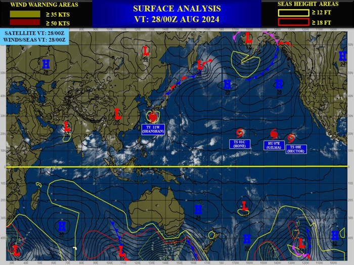
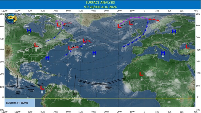
CLICK ON THE IMAGERIES BELOW TO GET THEM ENLARGED
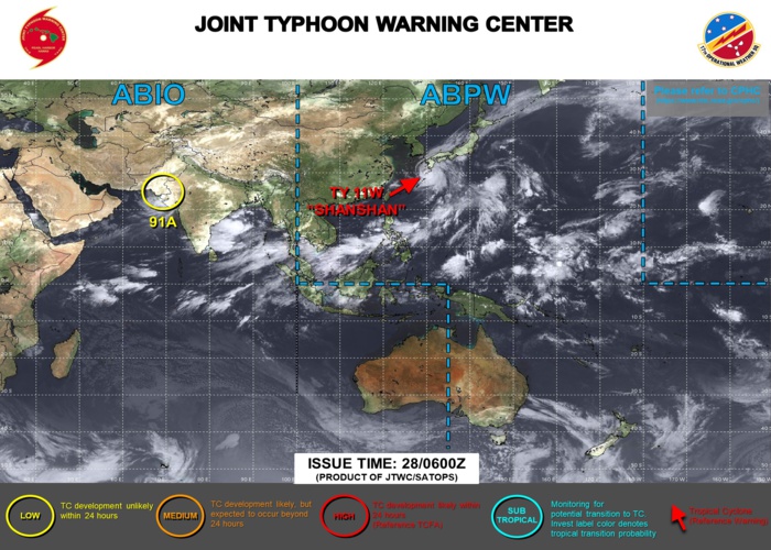
JTWC IS ISSUING 6HOURLY WARNINGS ON 11W, ON 01C AND ON 07E. 3HOURLY SATELLITE BULLETINS ARE ISSUED ON 11W ON 01C AND ON 07E
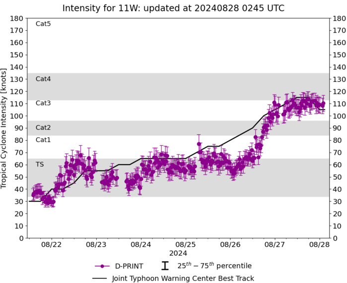
WESTERN NORTH PACIFIC: TY 11W(SHANSHAN). 28/00UTC ESTIMATED INTENSITY IS 105 KNOTS/CAT 3 US: STABLE OVER 24H. PEAK INTENSITY WAS 115 KNOTS/CAT 4
1124082512 264N1365E 75
1124082518 269N1350E 75
1124082600 273N1339E 80
1124082606 276N1328E 85
1124082612 278N1319E 90
1124082618 280N1311E 100
1124082700 282N1307E 105
1124082706 285N1304E 110
1124082712 286N1303E 115
1124082718 290N1301E 115
1124082800 293N1301E 105
1124082518 269N1350E 75
1124082600 273N1339E 80
1124082606 276N1328E 85
1124082612 278N1319E 90
1124082618 280N1311E 100
1124082700 282N1307E 105
1124082706 285N1304E 110
1124082712 286N1303E 115
1124082718 290N1301E 115
1124082800 293N1301E 105
WARNING 27 ISSUED AT 2803UTC
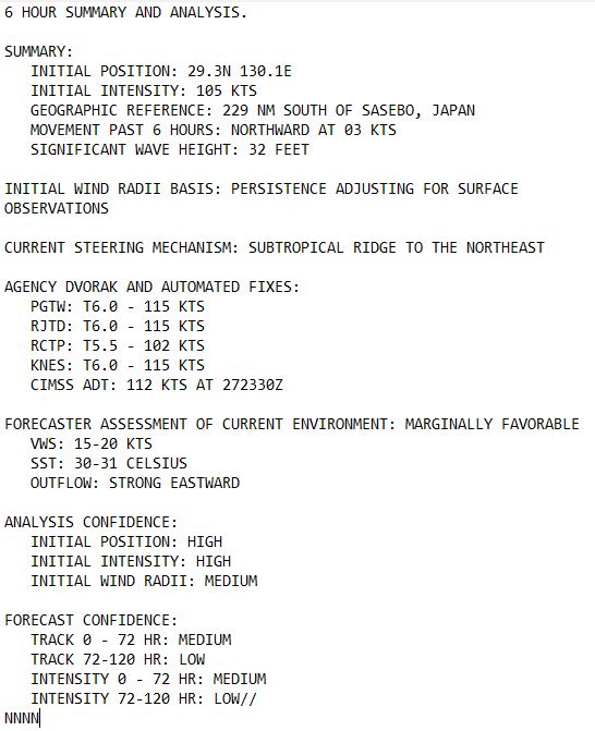
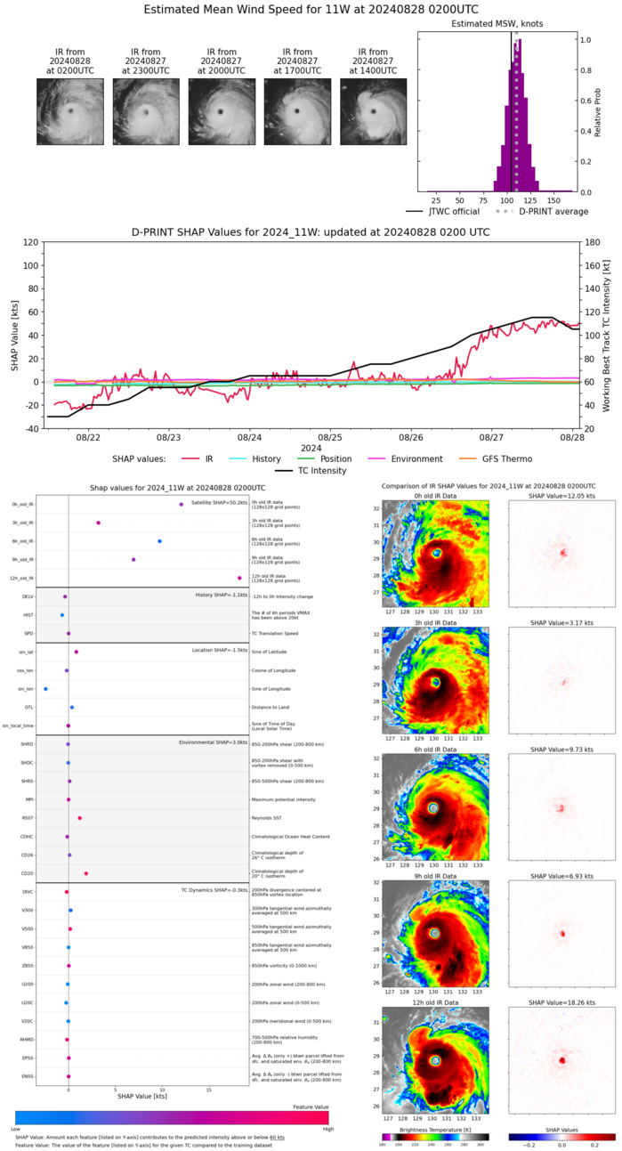
SATELLITE ANALYSIS, INITIAL POSITION AND INTENSITY DISCUSSION: ANIMATED MULTISPECTRAL SATELLITE IMAGERY (MSI) DEPICTS A TYPHOON STRUCTURE THAT HAS DECAYED SOMEWHAT SINCE THE PREVIOUS WARNING. THE EYE HAS COOLED AND BECOME LESS CLOUD-FREE, COINCIDENT WITH A SLIGHT WARMING OF THE EYEWALL CLOUD TOPS AND COMPLETE EROSION OF THE WESTERN EYEWALL IN JAPANESE RADAR IMAGERY. THIS COULD BE DUE TO EARLY ONSET OF OCEANIC UPWELLING BENEATH THE STORM, COUPLED WITH THE IMPACTS OF ONGOING LIGHT TO MODERATE NORTHWESTERLY SHEAR, BUT OCEANIC COOLING IS DIFFICULT TO CONFIRM. THE STORM BRIEFLY SLOWED AND TOOK A NORTHWARD JOG DURING THE PAST SIX HOURS, WHICH MAY HAVE EXACERBATED ANY UPWELLING THAT IS OCCURRING. POLEWARD UPPER-LEVEL OUTFLOW HAS RECOVERED SOMEWHAT IN THE NORTHERN SEMICIRCLE IN RESPONSE TO THE TROUGH OVER THE SEA OF JAPAN, BUT OUTFLOW REMAINS CONCENTRATED PRIMARILY EASTWARD AND EQUATORWARD. THE INITIAL INTENSITY IS LOWERED TO 105 KT BASED ON A BLEND OF AGENCY DVORAK ESTIMATES AND OBJECTIVE SATELLITE ESTIMATES, ALONG WITH A 272112Z RCM-2 SAR IMAGE SHOWING A MAXIMUM SURFACE WIND ESTIMATE OF 107 KT. ONOAIDA, JAPAN LOCATED ABOUT 60 NM NORTH-NORTHEAST OF THE EYE IS CURRENTLY MEASURING SUSTAINED WINDS OF 48 KT.
TC Warning Graphic
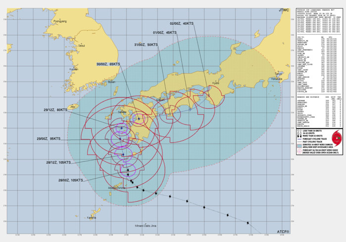
FORECAST REASONING. SIGNIFICANT FORECAST CHANGES: THERE ARE NO SIGNIFICANT CHANGES TO THE FORECAST FROM THE PREVIOUS WARNING. FORECAST DISCUSSION: TYPHOON 11W (SHANSHAN) CONTINUES TO MOVE LETHARGICALLY THROUGH THE RYUKYU ISLAND CHAIN. STEERING CURRENTS ARE WEAK AS THE TYPHOON IS MIRED JUST SOUTHEAST OF A COL IN THE DEEP-LAYER STEERING FLOW NEAR THE SOUTHERN KOREA PENINSULA. AN UPPER-LEVEL TROUGH OVER THE SEA OF JAPAN IS EXPECTED TO ALLOW SHANSHAN TO CONTINUE MAKING PROGRESS NORTH-NORTHWESTWARD OR NORTHWARD DURING THE NEXT 36 HOURS, BUT WILL THEN PULL OUT TO THE NORTHEAST, LEAVING THE STORM IN EVEN WEAKER STEERING CURRENTS. AT THIS POINT, MODELS GENERALLY AGREE THAT A VERY SLOW BUT SHARP TURN TOWARDS THE EAST WILL TAKE PLACE AS A WEAK RIDGE BUILDS IN SOUTHEAST OF THE TYPHOON, BRINGING SHANSHAN INLAND OVER KYUSHU BETWEEN 36 AND 48 HOURS. DURING THIS TURN, WIND SHEAR IS EXPECTED TO BE LOW, BUT OCEAN HEAT CONTENT VALUES DECREASE SIGNIFICANTLY IN THE WATERS SOUTH OF SASEBO RELATIVE TO WHERE SHANSHAN IS NOW. COMBINED WITH A SLOW FORWARD MOTION OF 5 KT OR LESS, THIS WILL RESULT IN MORE ACUTE OCEANIC COOLING BENEATH THE STORM THAN IS CURRENTLY OCCURRING, LEADING TO A MORE RAPID PACE OF WEAKENING JUST BEFORE LANDFALL. THE JTWC FORECAST SHOWS WEAKENING TO 80 KT PRIOR TO LANDFALL, BUT THE LANDFALL INTENSITY WILL BE SENSITIVE TO EXACTLY HOW LONG IT TAKES THE TYPHOON TO TRANSIT THE WATERS SOUTHWEST OF KYUSHU. AFTER LANDFALL, MODELS BEGIN TO DISAGREE SIGNIFICANTLY ON THE STORM'S TRACK DUE TO CONTINUING WEAK STEERING CURRENTS, WITH THE JET STREAM STAYING WELL NORTH OF THE STORM. A SECOND UPPER-LEVEL TROUGH IS EXPECTED TO BRIEFLY DIG INTO NORTHEASTERN CHINA AND SOUTHEASTERN RUSSIA IN ABOUT 72 HOURS, WHICH SOME MODELS LIKE GALWEM AND JGSM EXPECT TO BE STRONG ENOUGH TO USHER SHANSHAN NORTHEASTWARD INTO HONSHU. HOWEVER, THIS TROUGH ALSO EXITS QUICKLY, AND OTHER MODELS LEAVE SHANSHAN MAROONED SOUTH OF THE JETSTREAM EVEN AFTER THIS SECOND TROUGH PASSES, EITHER STALLING OR MOVING SLOWLY EASTWARD. THE GFS AND HAFS MODELS EVEN DEPICT A MEANDERING, LOOPING TRACK BACK WESTWARD OVER KYUSHU. THE JTWC FORECAST MAINTAINS A SLOW EAST-NORTHEASTWARD MOTION NEAR SHIKOKU DURING THE 72-120 HOUR PERIOD, BUT THERE IS HIGHER THAN AVERAGE UNCERTAINTY IN THE TRACK AFTER 48 HOURS, AND ERRATIC STORM MOTION IS POSSIBLE IN THE VICINITY OF KYUSHU AND SHIKOKU. THERE IS ALSO LOWER CONFIDENCE IN THE INTENSITY DURING THIS PORTION OF THE TRACK, AS THE STORM COULD REMAIN OVER LAND OR MOVE BACK OVER WATER SOUTH OF JAPAN FOR A TIME. HOWEVER, WEAKENING IS GENERALLY EXPECTED AFTER THE INITIAL LANDFALL DUE TO CONTINUING LAND INTERACTION AND THE PRESENCE OF DRY AIR AROUND THE STORM DEPOSITED BY THE PASSING UPPER-LEVEL TROUGHS.
Model Diagnostic Plot
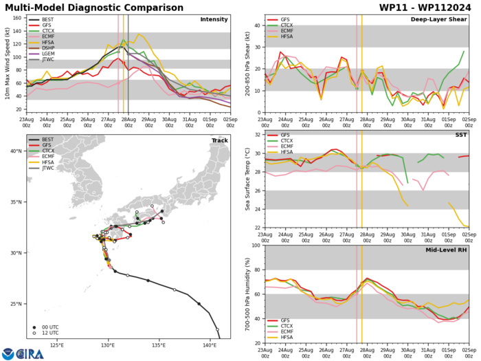
MODEL DISCUSSION: THE JTWC TRACK FORECAST IS A BIT SLOWER THAN THE MULTI-MODEL CONSENSUS, LEANING TOWARDS THE MORE RELIABLE MEMBERS SUCH AS ECMWF, GFS, EPS ENSEMBLE MEAN, GEFS ENSEMBLE MEAN WHICH ARE SLOWER THAN THE FAST OUTLIERS JGSM AND GALWEM. OVERALL, TRACK SPREAD NEAR JAPAN REMAINS IMMENSE, MAINLY IN THE ALONG-TRACK DIRECTION. THE JTWC INTENSITY FORECAST IS CLOSE TO THE MULTI-MODEL CONSENSUS, BUT WITH LOW CONFIDENCE BEYOND 72 HOURS, PRIMARILY DUE TO THE WIDELY DISPARATE TRACK PREDICTIONS WHICH INFLUENCE THE INTENSITY FORECAST.
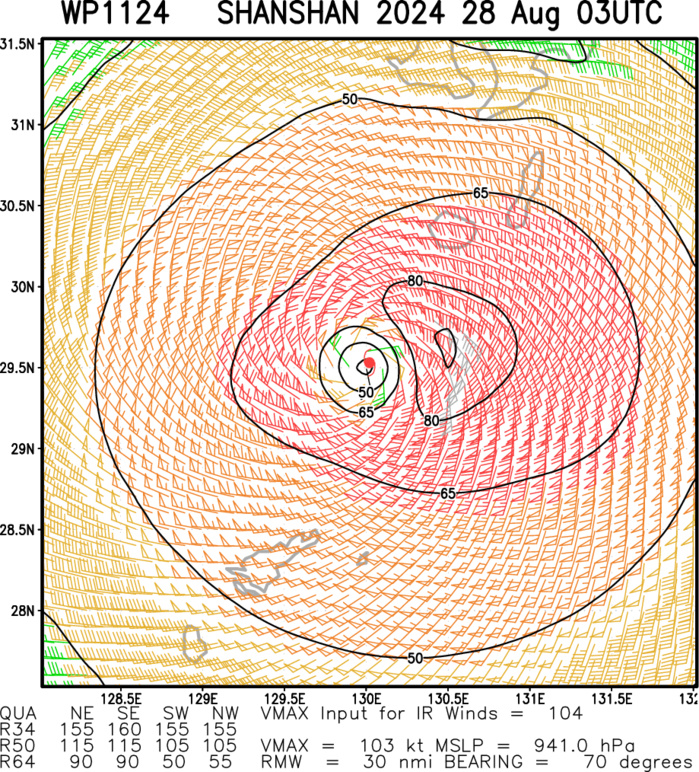
Multiplatform Satellite Surface Wind Analysis (Experimental)
28/0240UTC DVORAK ANALYSIS
TPPN10 PGTW 280302
A. TYPHOON 11W (SHANSHAN)
B. 28/0240Z
C. 29.54N
D. 130.14E
E. ONE/GK2A
F. T5.0/6.0/W0.5/24HRS STT: S0.0/03HRS
G. IR/EIR/VIS/MSI
H. REMARKS: 07A/PBO IRREG EYE/ANMTN. OW EYE SURROUNDED BY LG YIELDS
AN E# AND DT (NO EYE ADJUSTMENT) OF 5.0. MET YIELDS 6.5. PT YIELDS
5.5. DBO DT.
I. ADDITIONAL POSITIONS: NONE
EL-NAZLY
NORTH INDIAN/ARABIAN SEA: INVEST 91A: 2718UTC ESTIMATED LOCATION AND INTENSITY. 2718UTC ADVISORY
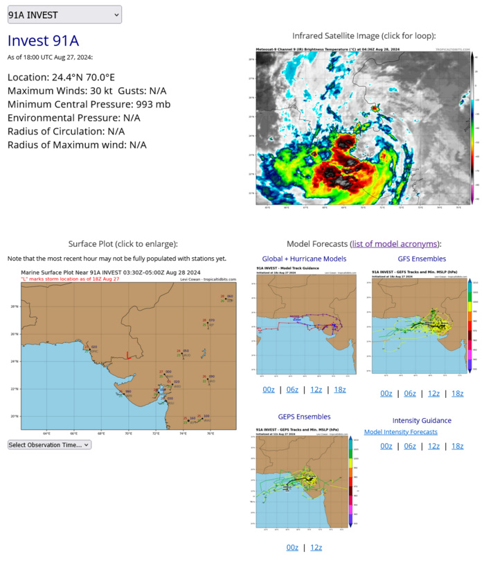
AN AREA OF CONVECTION (INVEST 91A) HAS PERSISTED NEAR 24.3N 70.5E, APPROXIMATELY 189 NM EAST OF KARACHI, PAKISTAN. ENHANCED INFRARED IMAGERY AND A 271328Z SSMIS F-17 91GHZ SATELLITE IMAGE DEPICTS A BROAD BUT WELL-DEFINED CIRCULATION WITH DEEP CONVECTION IN THE SOUTHWEST QUADRANT. SCATTEROMETERY DATA SHOWS OFFSHORE FLOW OF WESTERLY WINDS PEAKING AT 25 KNOTS. 91A IS IN A MARGINALLY FAVORABLE ENVIRONMENT FOR DEVELOPMENT WITH GOOD EQUATORWARD OUTFLOW, BUT ITS LOCATION IS CURRENTLY OVER LAND, HINDERING DEVELOPMENT. MODELS ARE IN GOOD AGREEMENT THAT 91A WILL TRACK WESTWARD OVER THE ARABIAN SEA DURING THE NEXT 48 HOURS, WHERE WARM SEA SURFACE TEMPERATURES (28-29C) AND MODERATE VWS (15-20KTS) WOULD REPRESENT AN OVERALL FAVORABLE ENVIRONMENT FOR DEVELOPMENT. MAXIMUM SUSTAINED SURFACE WINDS ARE ESTIMATED AT 28 TO 33 KNOTS. MINIMUM SEA LEVEL PRESSURE IS ESTIMATED TO BE NEAR 993 MB. THE POTENTIAL FOR THE DEVELOPMENT OF A SIGNIFICANT TROPICAL CYCLONE WITHIN THE NEXT 24 HOURS IS UPGRADED TO LOW.
Last Updated - 08/27/24 3 WEEK TROPICAL CYCLONE FORMATION PROBABILITY
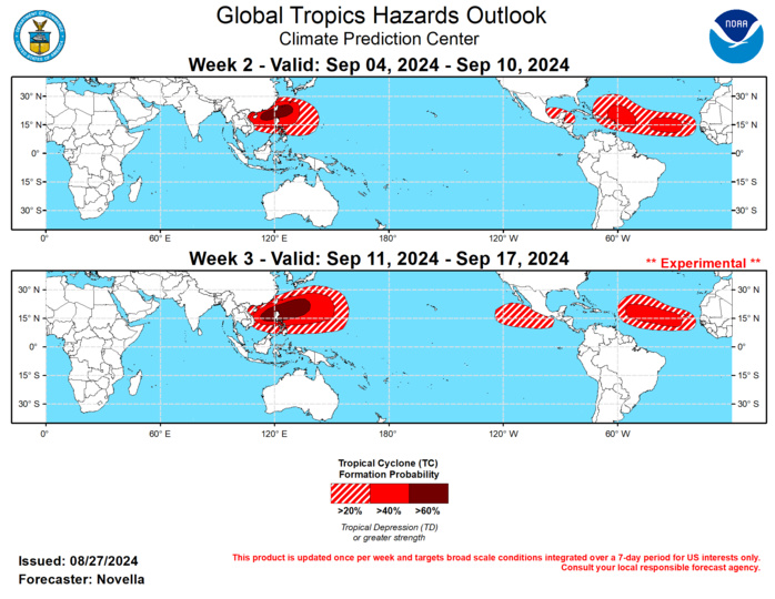
GTH Outlook Discussion Last Updated - 08/27/24 Valid - 09/04/24 - 09/17/24 The MJO has been largely coherent and has continued to propagate eastward over the Indian Ocean at a fairly high amplitude since the middle of August. The ongoing intraseasonal activity has endured competing interference with other modes of tropical variability, though more recent interference with strong equatorial Rossby wave activity has led to marked loss in amplitude as it recently entered the Maritime Continent. This is reflected in the latest RMM index observations (now in phase 4), as well as upper-level velocity potential anomaly fields revealing a less coherent wave-1 structure. However, RMM forecasts suggest that this weakening will be short-lived, as dynamical models remain supportive of the MJO regaining amplitude and continuing to propagate eastward over the Maritime Continent during the next two weeks. A notable consequence of this realization is the favored development of enhanced trades overspreading much of the equatorial Pacific, where any associated upwelling looks to aid in the transition to La Nina conditions entering boreal autumn. Compared to prior forecasts though, there is added uncertainty in regards to the coherence of the MJO before the enhanced phase reaches the Western Pacific towards mid-September. In particular, the GEFS features a more canonical and robust evolution of the MJO in both the RMM and upper-level velocity potential forecasts, whereas the ECMWF has trended more towards higher frequency variability becoming a more predominant driver, resulting in a more disorganized upper-level pattern at this lead. Regardless of these discrepancies in the guidance, a restrengthening MJO heading into September is expected to provide large scale conditions favorable for additional Tropical Cyclone (TC) development in the Western Pacific, with continued chances for formation in the Western Hemisphere. Should the MJO remain coherent by the time it reaches the Western Pacific, this historically favors increasingly less favorable conditions for development in the Eastern Pacific and tropical Atlantic. However, any lowered TC potential is likely to be counteracted by a very active climatology, more than sufficiently warm SSTs, as well as other modes of transient variability to contribute to TC genesis in these basins. During the past week, three TCs formed in the global tropics. As the first TC to have formed in the Central Pacific since 2019, TC Hone formed on 8/22 and strengthened to Category 1 Hurricane as it tracked westward, passing just south of the Big Island of Hawaii. Hone brought many adverse impacts to the state including torrential rainfall amounts (amounts exceeding two feet in a few local areas), flooding, landslides, and damages to infrastructure this past weekend. Since weakening to Tropical Storm to the west of the state, the National Hurricane Center (NHC) expects Hone to succumb to a hostile shear environment and become post-tropical low near the Date Line later this week. Farther east, TC Hector formed on 8/25 near 16N/122E and has continued to track westward, currently peaking as a Tropical Storm into the Central Pacific. Having tracked mostly in the wake TC Gilda (which formed back on 8/18), the cool upwelled waters have precluded Hector gaining much strength in the past few days, and the NHC forecasts Hector continue to gradually weaken to remnant low later this week. In the western Pacific, TC Shanshan formed on 8/21 near 17N/142E and has turned northwestward over Philippine Sea under the influence of subtropical ridge. Since strengthening to a category 3 Typhoon, the Joint Typhoon Warning Center (JTWC) forecasts Shanshan to slightly weaken before making landfall over Kyushu, Japan in the next few days. Shanshan is expected to rapidly weaken due to land interaction but likely bring heavy precipitation amounts and high winds for many parts of Japan. However, there is large uncertainty with the forecast track as models remain divided as to whether the low becomes trapped under the subtropical ridge and dissipates over Japan, or recurves and eventually undergo extratropical transition. Depending on the timing of the latter realization, this may lead to the amplification of the mid-level pattern downstream over North America. For the upcoming week, model guidance and tools indicate additional TC development is possible over the western Pacific following TC Shanshan. Tied to the enhanced phase of the MJO, there are also increased signals in the probabilistic tools for development in both the Arabian Sea and Bay of Bengal, however any formation seems less likely in the northern Indian Ocean due to continued shearing from the Indian monsoon. In the western Hemisphere, the NHC continues to eye TC Gilma which has been downgraded to Tropical Storm intensity since peaking at Major Hurricane strength over open waters during the past week. Gilma is forecast to maintain a westerly track, but dissipate into an open trough as it nears the Hawaiian Islands later this week. Although ensembles show the highest precipitation amounts remaining offshore, locally heavy precipitation amounts, elevated winds, and large swells are possible for parts of the state. Across the tropical Atlantic, there is good continuity in the dynamical models latching onto an easterly wave, where the NHC currently shows at least 20% chances for development in the Main Development Region (MDR) during the next seven days. Probabilistic TC genesis tools suggest the highest chances for formation are late in week-1 between 60W and 40W, however development could be delayed due to increased shearing; 40% chances for genesis are issued for the week-2 outlook given uncertainty with timing, with a broad area of 20% chances to account for increased spread of the wave later next week. Upstream, ensembles and probabilistic tools also point to potential development associated with another easterly wave in the eastern MDR. Anomalous lower-level westerlies are favored to be robust with lesser shearing in this part of the MDR during the first week of September, but confidence is tempered by any dust concentrations that are expected to linger (based on NASA GMAO-GEOS model) and inhibit formation in this region, resulting in 40% chances being posted for week-2. Farther west, a large frontal boundary is favored to sweep southward over the southeastern CONUS early in week-2, and bring increased precipitation amounts over the Gulf of Mexico and western Atlantic. While support remains modest in the ensembles and probabilistic tools for development near the tail end of this surface feature, 20% chances for TC development are posted from the Bay of Campeche to the Gulf of Honduras for week-2. In the eastern Pacific, no TC shapes are issued given little to no support in the guidance and the suppressed phase of the MJO overhead. For week-3, the combination of anomalously warm SSTs, climatology, and possible Kelvin wave activity over the tropical Atlantic by mid-September supports 40% chances for TC genesis for much of the MDR. Guidance also shows conditions becoming more favorable for development in the eastern Pacific, and 20% chances are issued to the south of Mexico. In the western Pacific, the continued eastward propagation of the MJO over the Maritime Continent historically supports increased chances for TC development in the South China and Philippine Seas based on composites. Despite some of the uncertainties with MJO between the GEFS and ECMWF entering the western Pacific, 60% chances are issued for both weeks 2 and 3 in the region due to good support in dynamical models. An eastward expansion of 40% and 20% chances into the Mariana Islands are posted for week-3 given increased signals over this part of the western Pacific in the extended range guidance.
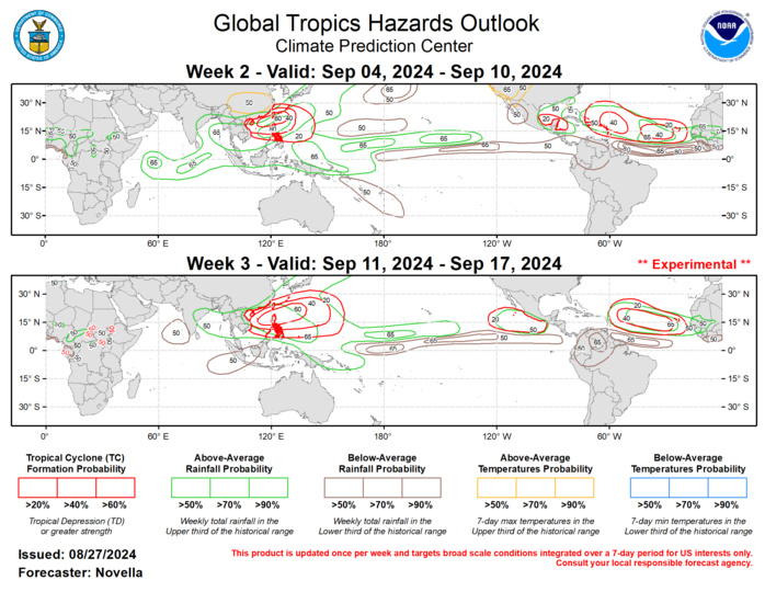
Forecasts for enhanced and suppressed precipitation for weeks 2 and 3 are based on historical composites of Maritime Continent MJO events, anticipated TC tracks, and a skill weighted consensus of the CFS, GEFS, ECMWF, and ECCC model systems, with some consideration of ENSO cold phase composites. Tied to amplified ridging favored over south-central Canada, increased chances for above-normal temperatures are forecast for much of the CONUS west of the Mississippi. Similarly, above-normal temperatures are posted for parts of eastern Asia during week-2. For hazardous weather conditions in your area during the next two weeks, please refer to your local NWS office, the Medium Range Hazards Forecast from the Weather Prediction Center (WPC), and the CPC Week-2 Hazards Outlook. Forecasts issued over Africa are made in coordination with the International Desk at CPC.
