Menu

Tropical Cyclone Formation Alert for Invest 92W// 3 week GTHO maps// 1903utc


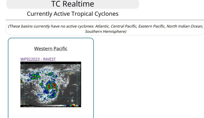
JTWC IS ISSUING 3HOURLY SATELLITE BULLETINS ON INVEST 92W.

9223041800  26N1596E  15 9223041806  28N1599E  15 9223041812  30N1601E  15 9223041818  34N1600E  15 9223041900  39N1598E  20
9223041800 26N1596E 15 9223041806 28N1599E 15 9223041812 30N1601E 15 9223041818 34N1600E 15 9223041900 39N1598E 20

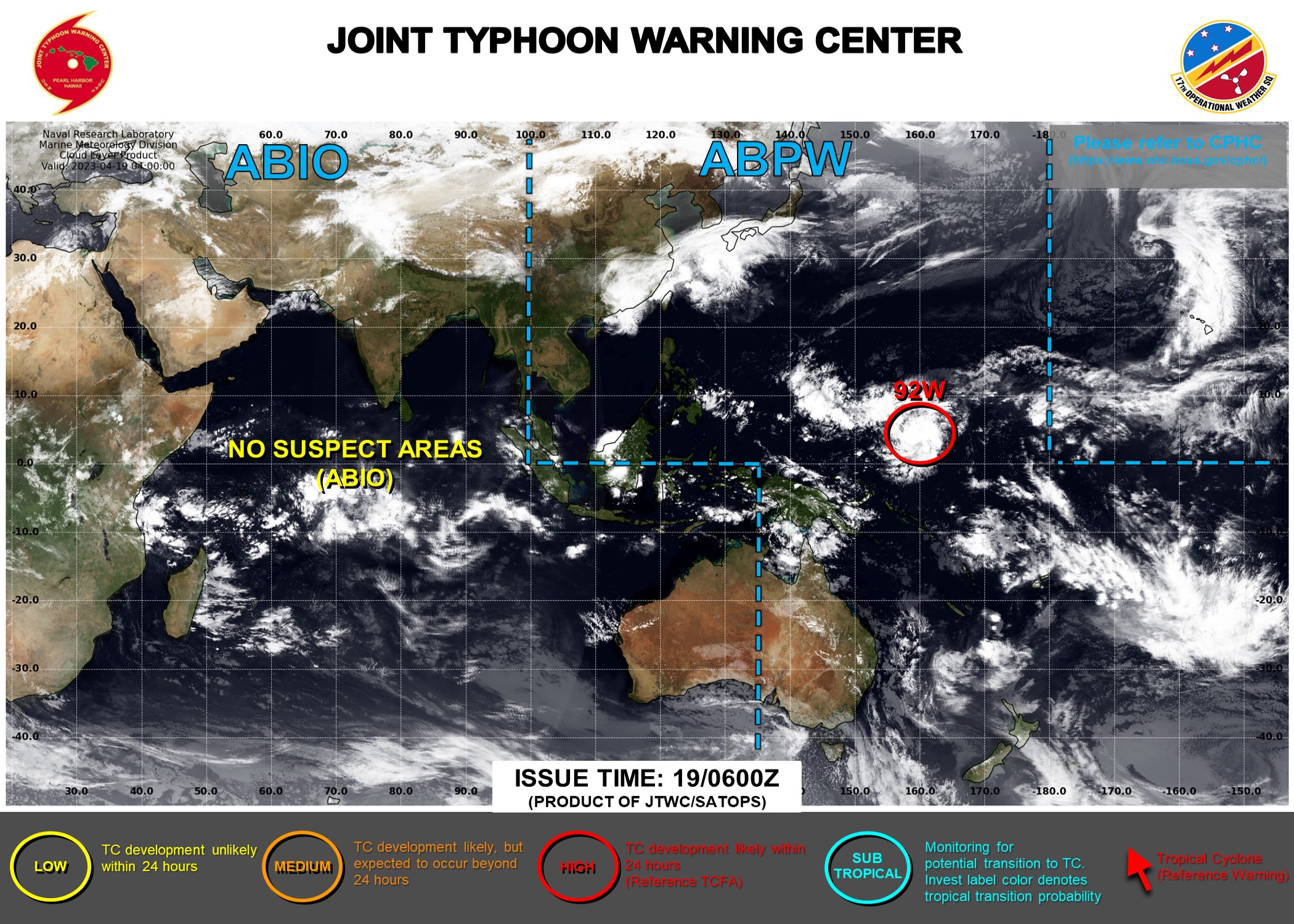
WESTERN NORTH PACIFIC: INVEST 92W. ESTIMATED LOCATION AND INTENSITY AT 19/00UTC.


TROPICAL CYCLONE FORMATION ALERT ISSUED AT 19/0130UTC.
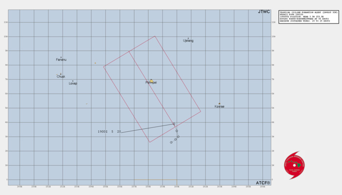
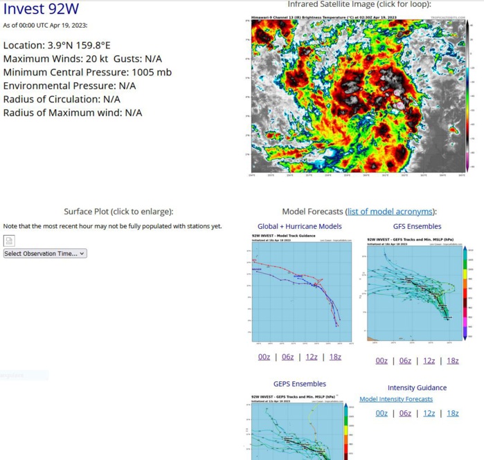
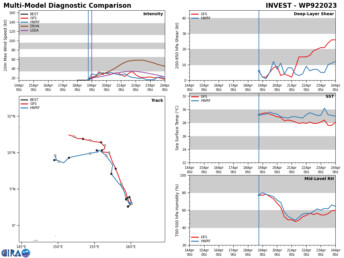
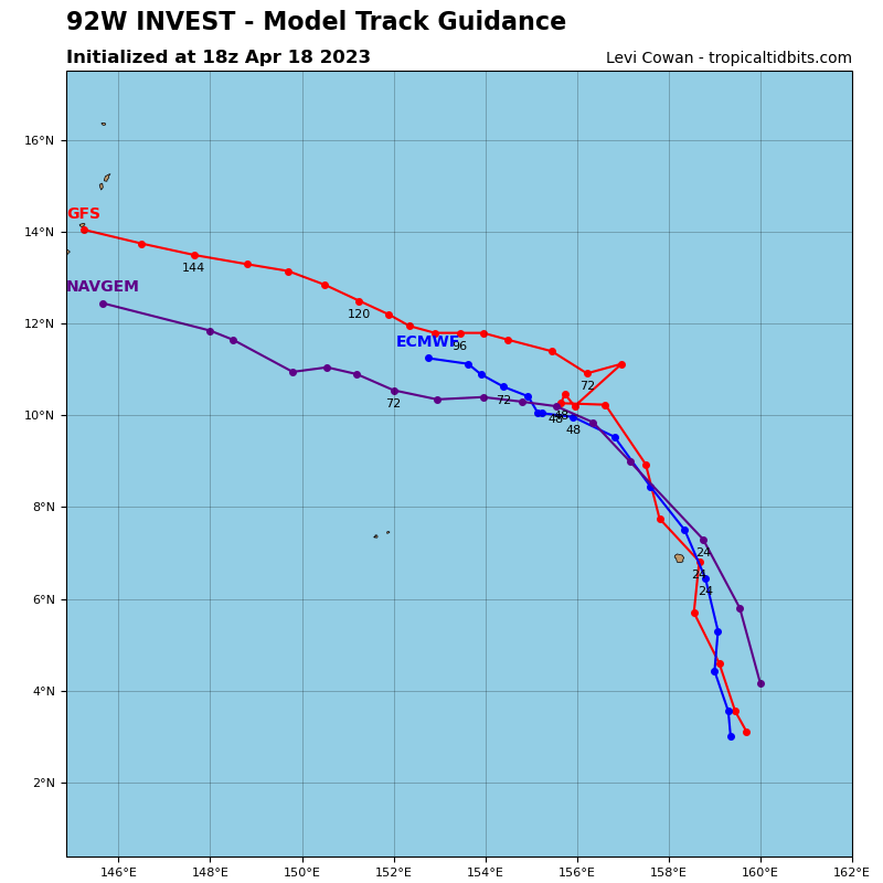
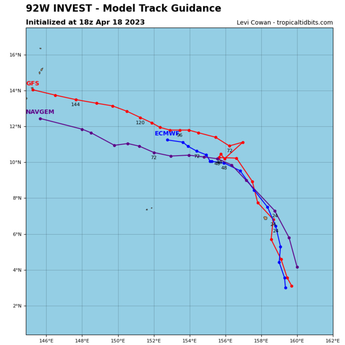
THE AREA OF CONVECTION (INVEST 92W) PREVIOUSLY LOCATED NEAR  3.2N 160.4E IS NOW LOCATED NEAR 3.9N 159.8E, APPROXIMATELY 206 NM SOUTH- SOUTHEAST OF POHNPEI. ANIMATED MULTISPECTRAL SATELLITE IMAGERY AND AN  182005Z SSMIS 91 GHZ MICROWAVE IMAGE DEPICT CURVED DEEP CONVECTIVE  BANDING WRAPPING INTO A WELL DEFINED AND CONSOLIDATED LOW LEVEL  CIRCULATION CENTER. UPPER LEVEL ANALYSIS SHOWS THAT 92W IS IN A  FAVORABLE ENVIRONMENT WITH LOW (05-10KT) VERTICAL WIND SHEAR, GOOD  DIVERGENCE ALOFT, AND WARM (29-30C) SEA SURFACE TEMPERATURES. GLOBAL  MODELS INDICATE A NORTH-NORTHWESTWARD TO NORTHWESTWARD TRACK OVER THE  NEXT TWO DAYS BUT ARE SPLIT ON DEVELOPMENT WITH ECMWF AND GFS DEVELOPING  A TROPICAL DEPRESSION IN THE NEXT ONE TO TWO DAYS AND NAVGEM INDICATING  WEAKER DEVELOPMENT. MAXIMUM SUSTAINED SURFACE WINDS ARE ESTIMATED AT 20  TO 25 KNOTS. MINIMUM SEA LEVEL PRESSURE IS ESTIMATED TO BE NEAR 1005 MB.  THE POTENTIAL FOR THE DEVELOPMENT OF A SIGNIFICANT TROPICAL CYCLONE  WITHIN THE NEXT 24 HOURS IS UPGRADED TO HIGH.
THE AREA OF CONVECTION (INVEST 92W) PREVIOUSLY LOCATED NEAR 3.2N 160.4E IS NOW LOCATED NEAR 3.9N 159.8E, APPROXIMATELY 206 NM SOUTH- SOUTHEAST OF POHNPEI. ANIMATED MULTISPECTRAL SATELLITE IMAGERY AND AN 182005Z SSMIS 91 GHZ MICROWAVE IMAGE DEPICT CURVED DEEP CONVECTIVE BANDING WRAPPING INTO A WELL DEFINED AND CONSOLIDATED LOW LEVEL CIRCULATION CENTER. UPPER LEVEL ANALYSIS SHOWS THAT 92W IS IN A FAVORABLE ENVIRONMENT WITH LOW (05-10KT) VERTICAL WIND SHEAR, GOOD DIVERGENCE ALOFT, AND WARM (29-30C) SEA SURFACE TEMPERATURES. GLOBAL MODELS INDICATE A NORTH-NORTHWESTWARD TO NORTHWESTWARD TRACK OVER THE NEXT TWO DAYS BUT ARE SPLIT ON DEVELOPMENT WITH ECMWF AND GFS DEVELOPING A TROPICAL DEPRESSION IN THE NEXT ONE TO TWO DAYS AND NAVGEM INDICATING WEAKER DEVELOPMENT. MAXIMUM SUSTAINED SURFACE WINDS ARE ESTIMATED AT 20 TO 25 KNOTS. MINIMUM SEA LEVEL PRESSURE IS ESTIMATED TO BE NEAR 1005 MB. THE POTENTIAL FOR THE DEVELOPMENT OF A SIGNIFICANT TROPICAL CYCLONE WITHIN THE NEXT 24 HOURS IS UPGRADED TO HIGH.


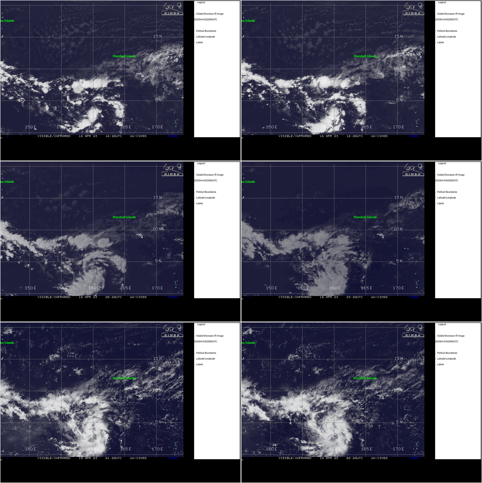
CLICK ON THE IMAGERY BELOW TO GET IT ANIMATED AND ENLARGED.
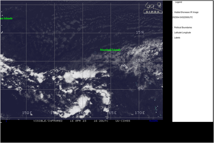
ANIMATED MULTISPECTRAL SATELLITE IMAGERY AND AN  182005Z SSMIS 91 GHZ MICROWAVE IMAGE DEPICT CURVED DEEP CONVECTIVE  BANDING WRAPPING INTO A WELL DEFINED AND CONSOLIDATED LOW LEVEL  CIRCULATION CENTER.
ANIMATED MULTISPECTRAL SATELLITE IMAGERY AND AN 182005Z SSMIS 91 GHZ MICROWAVE IMAGE DEPICT CURVED DEEP CONVECTIVE BANDING WRAPPING INTO A WELL DEFINED AND CONSOLIDATED LOW LEVEL CIRCULATION CENTER.


GLOBAL  MODELS INDICATE A NORTH-NORTHWESTWARD TO NORTHWESTWARD TRACK OVER THE  NEXT TWO DAYS BUT ARE SPLIT ON DEVELOPMENT WITH ECMWF AND GFS DEVELOPING  A TROPICAL DEPRESSION IN THE NEXT ONE TO TWO DAYS AND NAVGEM INDICATING  WEAKER DEVELOPMENT.
GLOBAL MODELS INDICATE A NORTH-NORTHWESTWARD TO NORTHWESTWARD TRACK OVER THE NEXT TWO DAYS BUT ARE SPLIT ON DEVELOPMENT WITH ECMWF AND GFS DEVELOPING A TROPICAL DEPRESSION IN THE NEXT ONE TO TWO DAYS AND NAVGEM INDICATING WEAKER DEVELOPMENT.
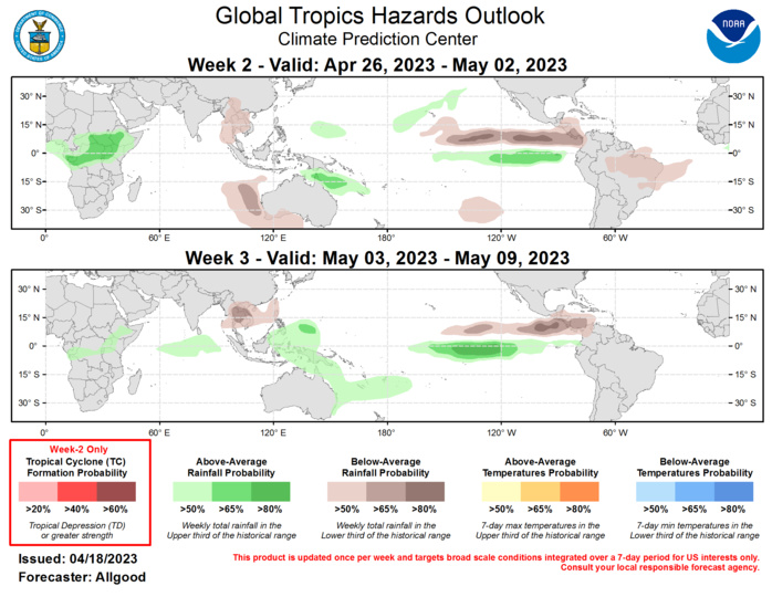


Last Updated - 04/18/23 Valid - 04/26/23 - 05/09/23 The Madden-Julian Oscillation (MJO) remains active, with both the CPC velocity potential and RMM-based MJO indices reflecting a high amplitude signal. The enhanced convective phase is currently traversing the Pacific, resulting in a disruption of the trade winds across the basin. The presentation of the MJO has become somewhat less coherent over the past week, particularly in the OLR field, due to interference with Rossby wave activity over the Maritime Continent and Indian Ocean, a residual suppressed signal near the Date Line, and Kelvin wave activity crossing the Western Hemisphere. Despite this interference, dynamical model MJO index forecasts continue to show a robust signal crossing the eastern Pacific and Western Hemisphere during Week-1. During Week-2, the forecast becomes more uncertain, as the ECMWF shows a potential for renewed Rossby wave interference over the Indian Ocean, and the GEFS exhibits a fast and weak propagation across the Indian Ocean, with the signal reaching the Maritime Continent or even the West Pacific by the end of Week-2. During Week-3, both the GEFS and ECMWF show a more robust MJO signal emerging over the West Pacific. Based on these outlooks, the MJO is favored to remain a dominant driver of broad-scale global tropical convective anomalies during the outlook period, with the signal potentially having a greater impact during Week-3 compared to Week-2. A slow transition from ENSO-neutral conditions to a warmer equatorial Pacific may also be playing a role in the complex evolution of the subseasonal signal.  No new tropical cyclones formed subsequent to powerful Cyclone Ilsa, which made landfall along Western Australia's coast on 13 April near Port Hedland at strong Category-4 intensity on the Saffir-Simpson scale. There is a slight potential for tropical cyclogenesis southeast of Guam during Week-1, which may bring impacts to the vicinity of Guam or nearby islands during the beginning of the Week-2 period. During Week-2, there are no regions favored for tropical cyclone development, as dynamical models show a fairly quiet pattern and climatological development is low during late April and early May.  The precipitation outlooks for Weeks 2 and 3 are based on a consensus of GEFS, ECMWF, and CFS dynamical model guidance, and canonical precipitation patterns during MJO events propagating from the Maritime Continent to the West Pacific, particularly for Week-3. Below-normal precipitation favored for portions of Southeast Asia and the southeastern Indian Ocean are based on dynamical model guidance and are not consistent with Indian Ocean MJO events. The dry signals in these regions could be due to Rossby wave influence or a faster MJO propagation to the Maritime Continent or West Pacific. Dynamical models also favor a persistent wet pattern for portions of Africa, and wet conditions across the equatorial East Pacific in response to warming sea surface temperatures. Wet conditions may continue to exacerbate flooding conditions across portions of Ecuador and Peru.
Last Updated - 04/18/23 Valid - 04/26/23 - 05/09/23 The Madden-Julian Oscillation (MJO) remains active, with both the CPC velocity potential and RMM-based MJO indices reflecting a high amplitude signal. The enhanced convective phase is currently traversing the Pacific, resulting in a disruption of the trade winds across the basin. The presentation of the MJO has become somewhat less coherent over the past week, particularly in the OLR field, due to interference with Rossby wave activity over the Maritime Continent and Indian Ocean, a residual suppressed signal near the Date Line, and Kelvin wave activity crossing the Western Hemisphere. Despite this interference, dynamical model MJO index forecasts continue to show a robust signal crossing the eastern Pacific and Western Hemisphere during Week-1. During Week-2, the forecast becomes more uncertain, as the ECMWF shows a potential for renewed Rossby wave interference over the Indian Ocean, and the GEFS exhibits a fast and weak propagation across the Indian Ocean, with the signal reaching the Maritime Continent or even the West Pacific by the end of Week-2. During Week-3, both the GEFS and ECMWF show a more robust MJO signal emerging over the West Pacific. Based on these outlooks, the MJO is favored to remain a dominant driver of broad-scale global tropical convective anomalies during the outlook period, with the signal potentially having a greater impact during Week-3 compared to Week-2. A slow transition from ENSO-neutral conditions to a warmer equatorial Pacific may also be playing a role in the complex evolution of the subseasonal signal. No new tropical cyclones formed subsequent to powerful Cyclone Ilsa, which made landfall along Western Australia's coast on 13 April near Port Hedland at strong Category-4 intensity on the Saffir-Simpson scale. There is a slight potential for tropical cyclogenesis southeast of Guam during Week-1, which may bring impacts to the vicinity of Guam or nearby islands during the beginning of the Week-2 period. During Week-2, there are no regions favored for tropical cyclone development, as dynamical models show a fairly quiet pattern and climatological development is low during late April and early May. The precipitation outlooks for Weeks 2 and 3 are based on a consensus of GEFS, ECMWF, and CFS dynamical model guidance, and canonical precipitation patterns during MJO events propagating from the Maritime Continent to the West Pacific, particularly for Week-3. Below-normal precipitation favored for portions of Southeast Asia and the southeastern Indian Ocean are based on dynamical model guidance and are not consistent with Indian Ocean MJO events. The dry signals in these regions could be due to Rossby wave influence or a faster MJO propagation to the Maritime Continent or West Pacific. Dynamical models also favor a persistent wet pattern for portions of Africa, and wet conditions across the equatorial East Pacific in response to warming sea surface temperatures. Wet conditions may continue to exacerbate flooding conditions across portions of Ecuador and Peru.
Rédigé par PATRICK HOAREAU le Wednesday, April 19th 2023 à 07:15