Menu

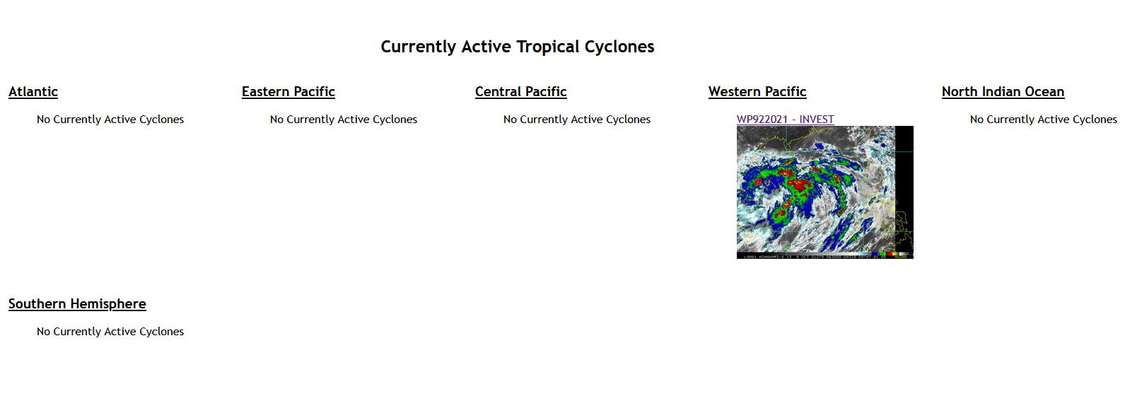
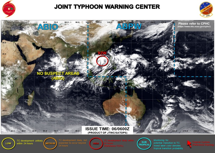
Invest 92W:TCFA re-issued/2 WEEK CYCLONIC DEVELOPMENT POTENTIAL: likely to be active East of the Philippines and over the BOB,06/06utc update


A TROPICAL CYCLONE FORMATION ALERT(TCFA) WAS RE-ISSUED FOR INVEST 92W AT 05/1430UTC. JTWC IS ISSUING 3HOURLY SATELLITE BULLETINS ON 92W.


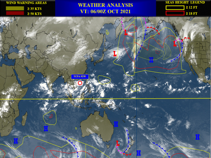
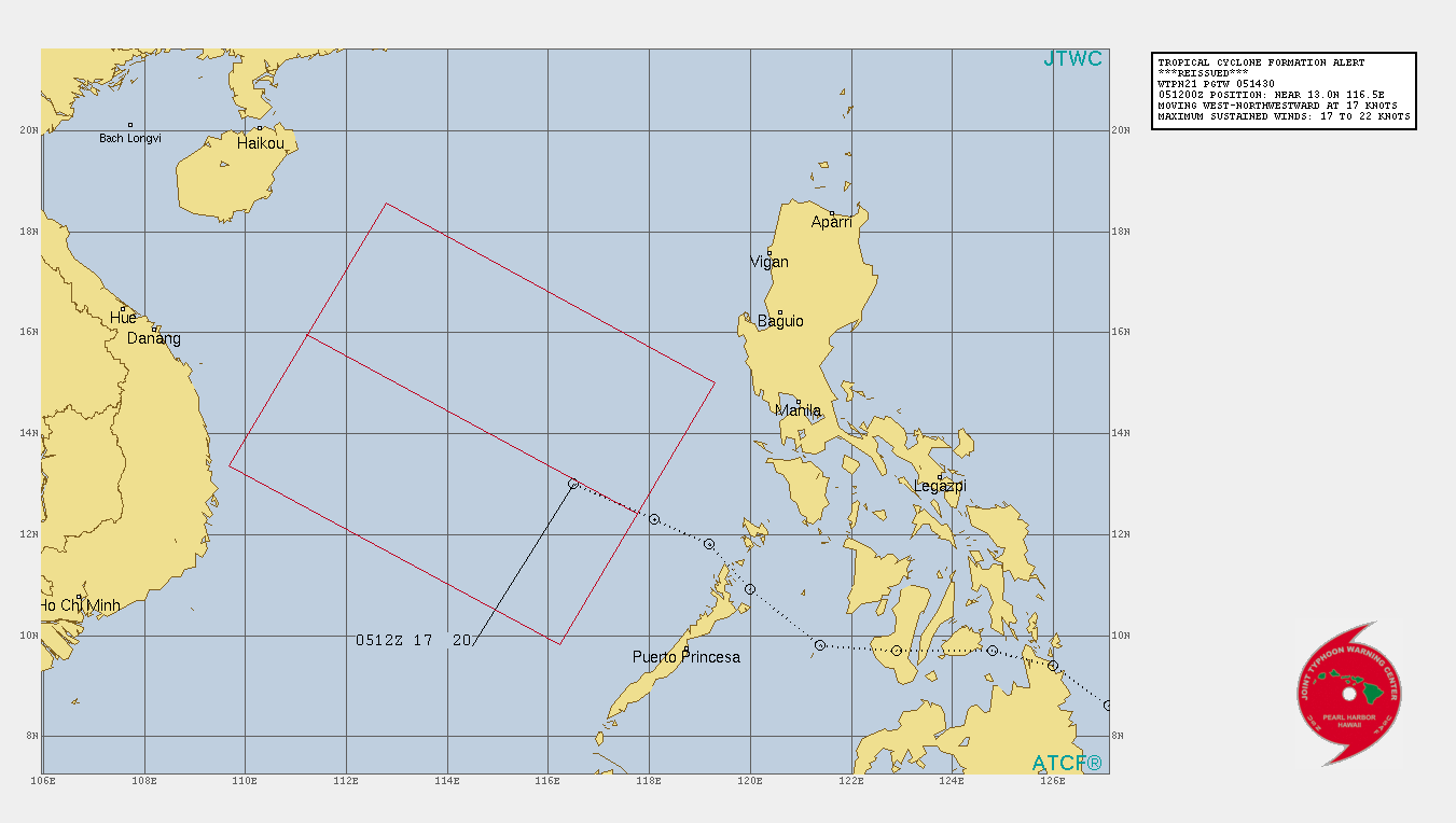
WESTERN NORTH PACIFIC: INVEST 92W. TROPICAL CYCLONE FORMATION ALERT RE-ISSUED AT 05/1430UTC WITH UP-DATE AT 06/06UTC
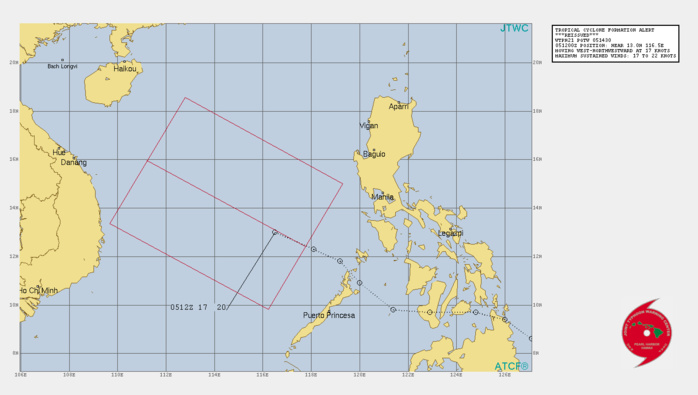
THE AREA OF CONVECTION (INVEST 92W) PREVIOUSLY LOCATED  NEAR 13.0N 116.5E IS NOW LOCATED NEAR 14.6N 114.0E, APPROXIMATELY  750 KM NORTHWEST OF PUERTO PRINCESA, PALAWAN. ANIMATED MULTISPECTRAL  SATELLITE IMAGERY DEPICTS BROAD, DISORGANIZED CONVECTION THAT  OBSCURES A BROAD, WEAK, AND ELONGATED LOW LEVEL CIRCULATION (LLC).  ENVIRONMENTAL ANALYSIS CONTINUES TO DEPICT MARGINALLY FAVORABLE  CONDITIONS FOR DEVELOPMENT WITH STRONG EQUATORWARD OUTFLOW AND VERY  WARM (30C) SEA SURFACE TEMPERATURES OFFSET BY MODERATE (15-20KT)  VERTICAL WIND SHEAR. A 052357Z DIRECT ASCAT-A PASS SHOWS MOSTLY 10- 15KT WIND BARBS AROUND THE LLC WITH PATCHES OF 20KT WIND BARBS IN  THE SOUTHEAST QUADRANT. MAXIMUM SUSTAINED SURFACE  WINDS ARE ESTIMATED AT 17 TO 22 KNOTS. MINIMUM SEA LEVEL PRESSURE IS  ESTIMATED TO BE NEAR 1006 MB. THE POTENTIAL FOR THE DEVELOPMENT OF A  SIGNIFICANT TROPICAL CYCLONE WITHIN THE NEXT 24 HOURS REMAINS HIGH.
THE AREA OF CONVECTION (INVEST 92W) PREVIOUSLY LOCATED NEAR 13.0N 116.5E IS NOW LOCATED NEAR 14.6N 114.0E, APPROXIMATELY 750 KM NORTHWEST OF PUERTO PRINCESA, PALAWAN. ANIMATED MULTISPECTRAL SATELLITE IMAGERY DEPICTS BROAD, DISORGANIZED CONVECTION THAT OBSCURES A BROAD, WEAK, AND ELONGATED LOW LEVEL CIRCULATION (LLC). ENVIRONMENTAL ANALYSIS CONTINUES TO DEPICT MARGINALLY FAVORABLE CONDITIONS FOR DEVELOPMENT WITH STRONG EQUATORWARD OUTFLOW AND VERY WARM (30C) SEA SURFACE TEMPERATURES OFFSET BY MODERATE (15-20KT) VERTICAL WIND SHEAR. A 052357Z DIRECT ASCAT-A PASS SHOWS MOSTLY 10- 15KT WIND BARBS AROUND THE LLC WITH PATCHES OF 20KT WIND BARBS IN THE SOUTHEAST QUADRANT. MAXIMUM SUSTAINED SURFACE WINDS ARE ESTIMATED AT 17 TO 22 KNOTS. MINIMUM SEA LEVEL PRESSURE IS ESTIMATED TO BE NEAR 1006 MB. THE POTENTIAL FOR THE DEVELOPMENT OF A SIGNIFICANT TROPICAL CYCLONE WITHIN THE NEXT 24 HOURS REMAINS HIGH.
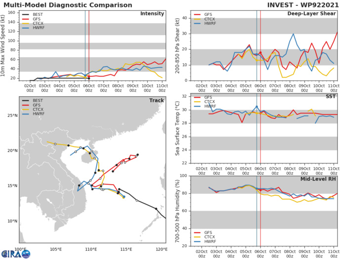
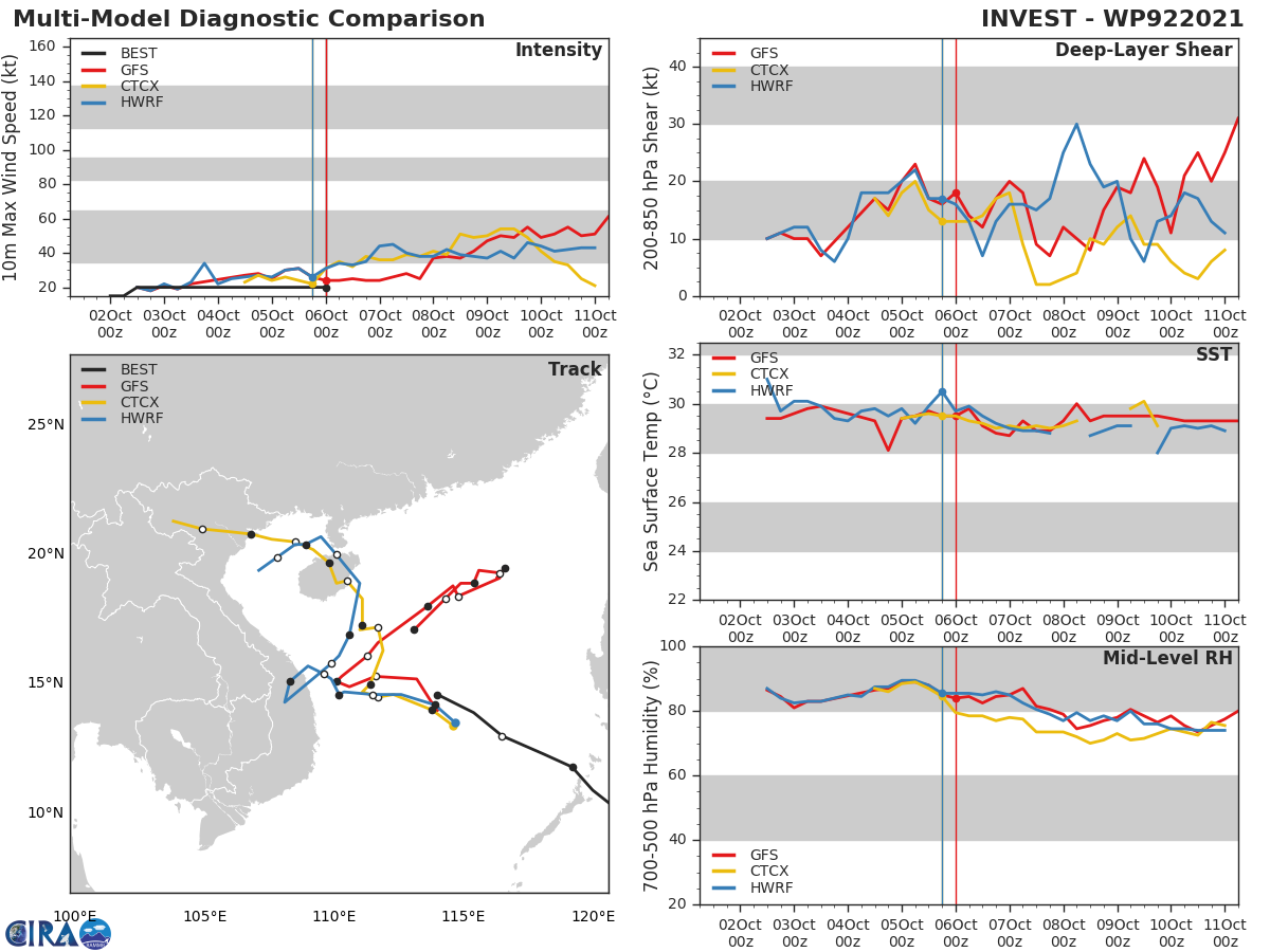
GLOBAL MODELS ARE IN OVERALL AGREEMENT THAT  92W WILL CONTINUE TO TRACK GENERALLY NORTHWESTWARD WITH INCREASING  SPREAD TO OVER 520KM IN JUST TWO DAYS.
GLOBAL MODELS ARE IN OVERALL AGREEMENT THAT 92W WILL CONTINUE TO TRACK GENERALLY NORTHWESTWARD WITH INCREASING SPREAD TO OVER 520KM IN JUST TWO DAYS.


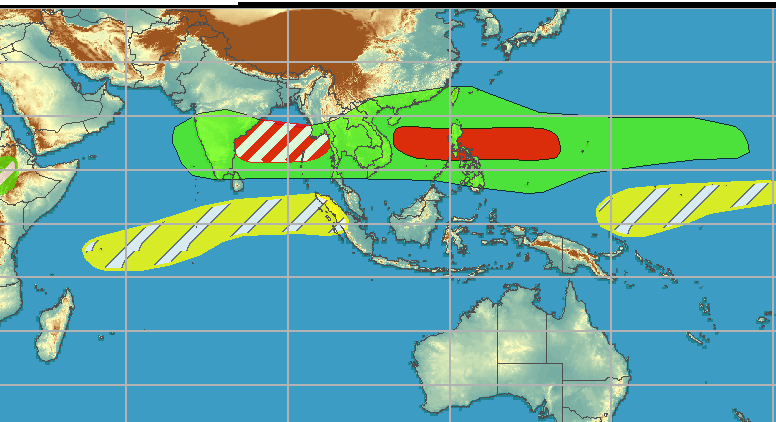
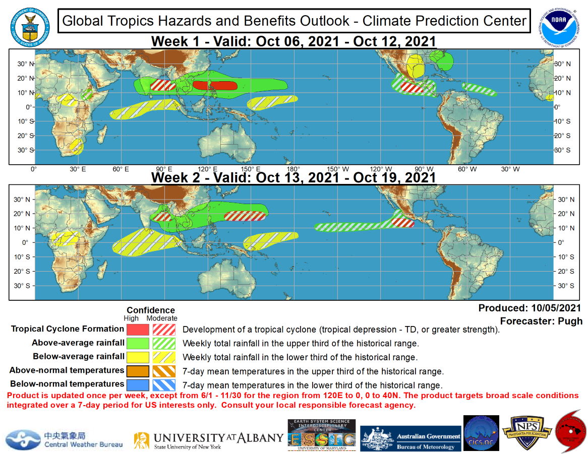
2 WEEK CYCLONIC DEVELOPMENT POTENTIAL.WEEK 1: OCTOBER 6 TO OCTOBER 12.
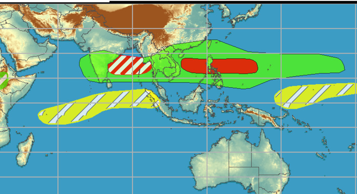
TC development is imminent across the South China Sea and this likely TC is forecast to track slowly, which could result in flooding across Hainan Island and/or parts of Vietnam during the next week. Another TC is likely to form just east of the Philippines during week-1, while model guidance favors a northeast shift across the West Pacific for the favored location by week-2. Enhanced convection, model guidance, and climatology support an increased chance of TC development across the Bay of Bengal through mid-October. Since timing is usually difficult to forecast for this region, a moderate confidence covers weeks 1 and 2. NOAA.
 Issued at 05/1830UTC by NOAA.
In collaboration with the JTWC and several well known organizations.

 Archives: HERE

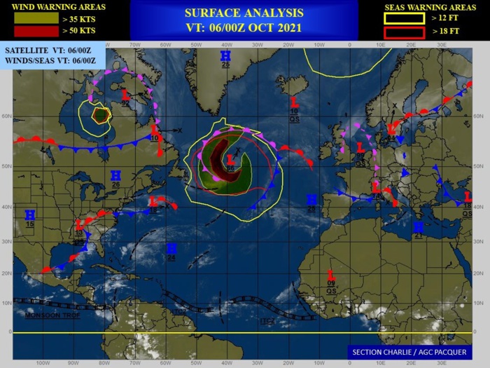
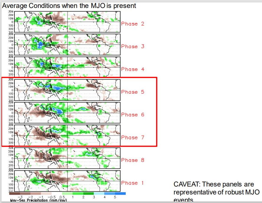
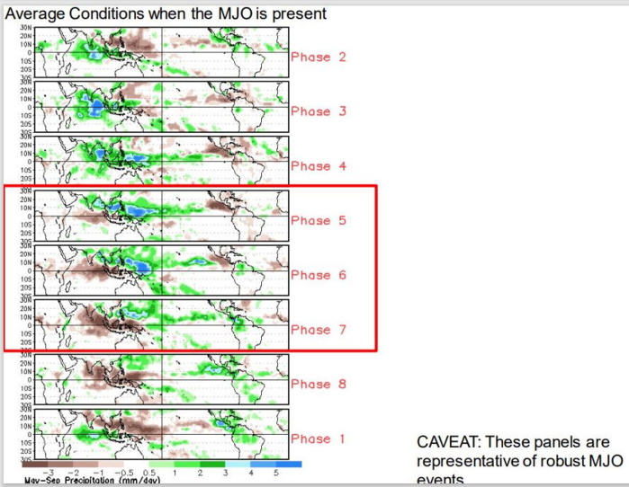
The Madden-Julian Oscillation (MJO) became more coherent and began to propagate eastward at the beginning of October, following the persistence of a low-frequency base state during September. Signs of a strengthening MJO include anomalous upper-level easterlies developing over the Maritime Continent and an increase in convection closer to the Date Line. Also, anomalous upper-level convergence intensified over the Americas and Caribbean Sea. Dynamical model forecasts are in good agreement that the MJO continues to propage east over the West Pacific during the next two weeks. However, large spread exists among ensemble members as the MJO destructively interferes with the emerging La Nina.  Following Hurricane Sam, the strongest (peak intensity of Category 4) and longest-lived hurricane of the 2021 Atlantic season, Tropical Storm Victor developed in the eastern Atlantic. Victor was much weaker and quickly dissipated due to strong vertical wind shear. The National Hurricane Center is currently monitoring a surface trough lifting north from the Bahamas. The most likely outcome later this week is for a frontal wave of low pressure to develop near the East Coast of the United States. Although no tropical cyclone (TC) development is favored throughout the Atlantic basin during the next two weeks, conditions are expected to become more favorable across the Caribbean later in October as the MJO shifts east to the Western Hemisphere. Also, the Caribbean becomes the typical region for TC development during late October. The GFS model remains the most bullish for TC genesis across the East Pacific later in week-1, but forecast confidence is only moderate due to the lack of additional model support. Moderate confidence for TC development is maintained through week-2 for the East Pacific as the large-scale environment is expected to be favorable.   The favored areas of above and below average rainfall are based on predicted TC tracks, dynamical model output, and MJO precipitation composites for phases 5, 6, and 7. The axis of heaviest rainfall is expected to shift north across South and Southeast Asia along with the West Pacific during the next two weeks. MJO precipitation composites for phases 5, 6, and 7 depict a drying trend over the Maritime Continent but this may be offset by the low-frequency base state. Enhanced rainfall is expected to shift east of the Date Line from early to mid-October.  Please refer to the National Hurricane Center for the latest updates and forecasts. For hazardous weather concerns during the upcoming two weeks across the U.S. please refer to your local NWS Forecast Office, the Weather Prediction Center's Medium Range Hazards Forecast, and CPC's Week-2 U.S. Hazards Outlook. Forecasts over Africa are made in consultation with the International Desk at CPC and can represent local-scale conditions in addition to global-scale variability.NOAA.
The Madden-Julian Oscillation (MJO) became more coherent and began to propagate eastward at the beginning of October, following the persistence of a low-frequency base state during September. Signs of a strengthening MJO include anomalous upper-level easterlies developing over the Maritime Continent and an increase in convection closer to the Date Line. Also, anomalous upper-level convergence intensified over the Americas and Caribbean Sea. Dynamical model forecasts are in good agreement that the MJO continues to propage east over the West Pacific during the next two weeks. However, large spread exists among ensemble members as the MJO destructively interferes with the emerging La Nina. Following Hurricane Sam, the strongest (peak intensity of Category 4) and longest-lived hurricane of the 2021 Atlantic season, Tropical Storm Victor developed in the eastern Atlantic. Victor was much weaker and quickly dissipated due to strong vertical wind shear. The National Hurricane Center is currently monitoring a surface trough lifting north from the Bahamas. The most likely outcome later this week is for a frontal wave of low pressure to develop near the East Coast of the United States. Although no tropical cyclone (TC) development is favored throughout the Atlantic basin during the next two weeks, conditions are expected to become more favorable across the Caribbean later in October as the MJO shifts east to the Western Hemisphere. Also, the Caribbean becomes the typical region for TC development during late October. The GFS model remains the most bullish for TC genesis across the East Pacific later in week-1, but forecast confidence is only moderate due to the lack of additional model support. Moderate confidence for TC development is maintained through week-2 for the East Pacific as the large-scale environment is expected to be favorable. The favored areas of above and below average rainfall are based on predicted TC tracks, dynamical model output, and MJO precipitation composites for phases 5, 6, and 7. The axis of heaviest rainfall is expected to shift north across South and Southeast Asia along with the West Pacific during the next two weeks. MJO precipitation composites for phases 5, 6, and 7 depict a drying trend over the Maritime Continent but this may be offset by the low-frequency base state. Enhanced rainfall is expected to shift east of the Date Line from early to mid-October. Please refer to the National Hurricane Center for the latest updates and forecasts. For hazardous weather concerns during the upcoming two weeks across the U.S. please refer to your local NWS Forecast Office, the Weather Prediction Center's Medium Range Hazards Forecast, and CPC's Week-2 U.S. Hazards Outlook. Forecasts over Africa are made in consultation with the International Desk at CPC and can represent local-scale conditions in addition to global-scale variability.NOAA.


06/0630UTC.
06/0630UTC.
Rédigé par PATRICK HOAREAU le Wednesday, October 6th 2021 à 11:04