

CLICK ON THE IMAGERIES BELOW TO GET THEM ENLARGED

JTWC PH
JTWC FACEBOOK
Joint Typhoon Warning Center
National Hurricane Center
GTH Outlook Discussion
Last Updated - 09/08/26
Valid - 09/16/26 - 09/29/26
The MJO remains active, with the enhanced convective phase now crossing the East Pacific and Western Hemisphere. Despite the active intraseasonal signal, the primary diagnostics used to track the MJO have had difficulty resolving the signal over the past few weeks due to the strength of the background El Niño response, which is dominating the global tropical convective field. The comparatively weaker MJO signal is most apparent in the upper-level velocity potential anomalies, and is serving more to modulate the strength of the ENSO response as the eastward propagating subseasonal signal moves into and out of constructive interference with the stationary ENSO base state rather than projecting its own enhanced and suppressed phases onto the tropical convective regime. Dynamical model MJO index forecasts continue to have difficulty resolving the intraseasonal propagation from the strengthening low frequency base state, with most GEFS ensemble members depicting a re-amplification of the West Pacific signal as any intraseasonal signal comes back into constructive interference later in the month. The ECMWF, however, depicts a more robust MJO propagation, with the majority of its ensemble members crossing the Western Hemisphere and Indian Ocean over the next several weeks at varying degrees of amplitude. This propagation is consistent with the recent evolution of the upper-level velocity potential field. Should a coherent subseasonal signal reach the Indian Ocean by late September, it would act in opposition to the ENSO base state, and may yield a brief window of increased favorability for Atlantic tropical cyclogenesis. Dynamical model forecasts, however, continue to show the El Niño associated divergence over the Pacific overwhelming any MJO activity, which would maintain strong shear and suppress convection across the Atlantic basin.
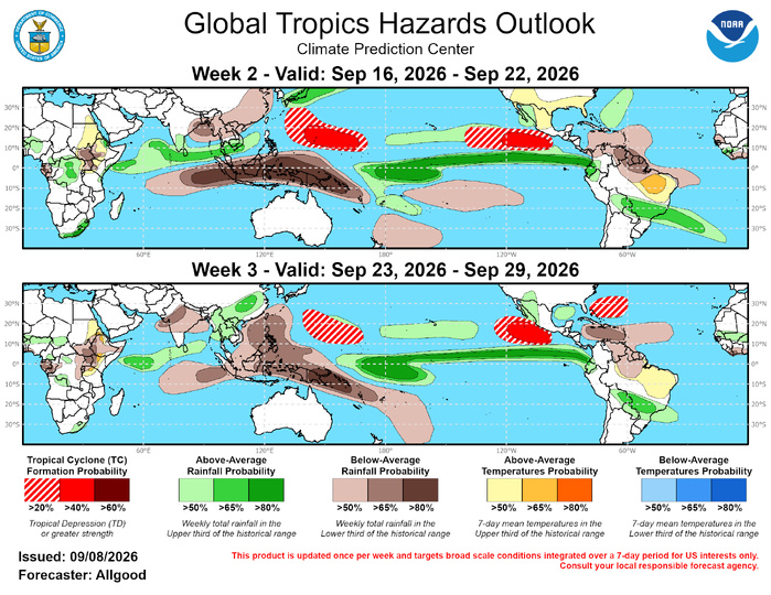
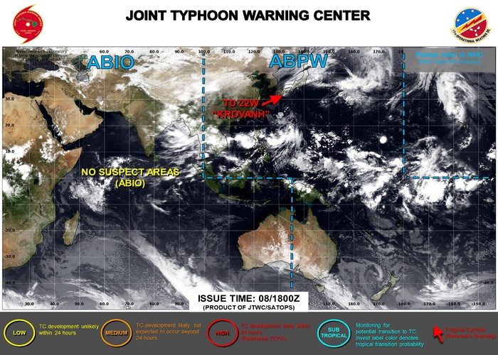
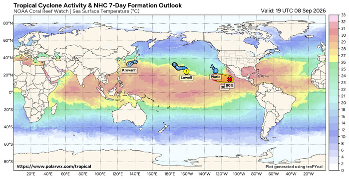
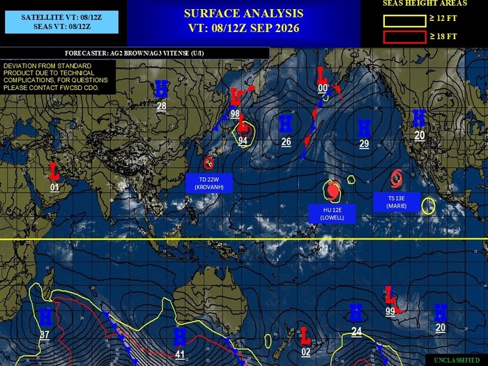
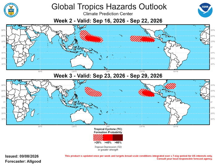
Only one tropical cyclone formed globally during the last week: Tropical Storm 23-W, which developed south of Japan and quickly lost convection in an unfavorable environment in close proximity to Tropical Storm Krovanh. This is a considerable reduction in activity following the previous week, where 7 tropical cyclones developed. Ongoing impacts from tropical cyclones that formed during that prior week remain a concern, with Hurricane Lowell bringing widespread rain, wind, and wave impacts to Hawaii, and Krovanh bringing heavy rainfall to Japan. Additional East and Central Pacific activity is likely during Week-1. During Week-2, the Pacific is favored to remain highly active under the strong El Niño regime, with tropical cyclogenesis favored across much of the East Pacific basin, and across the northwestern Pacific near and north of Guam. Despite the potential MJO evolution, the Atlantic basin is likely to remain unfavorable for development, and any waves emerging over the MDR would experience only brief development, if any. The MJO may increase the favorability for development closer to Mexico's southern coast during Week-3, rather than the southwestern portion of the East Pacific basin where most formations have occurred over the past few weeks. Across the Atlantic, MDR climatology begins to decrease towards the end of September, with environmental conditions remaining broadly unfavorable due to the strong Pacific divergence. Outside of the deep tropics, unsettled weather across the western Atlantic, near or north of the Bahamas, may provide an opportunity for tropical or subtropical development.
JTWC FACEBOOK
Joint Typhoon Warning Center
National Hurricane Center
GTH Outlook Discussion
Last Updated - 09/08/26
Valid - 09/16/26 - 09/29/26
The MJO remains active, with the enhanced convective phase now crossing the East Pacific and Western Hemisphere. Despite the active intraseasonal signal, the primary diagnostics used to track the MJO have had difficulty resolving the signal over the past few weeks due to the strength of the background El Niño response, which is dominating the global tropical convective field. The comparatively weaker MJO signal is most apparent in the upper-level velocity potential anomalies, and is serving more to modulate the strength of the ENSO response as the eastward propagating subseasonal signal moves into and out of constructive interference with the stationary ENSO base state rather than projecting its own enhanced and suppressed phases onto the tropical convective regime. Dynamical model MJO index forecasts continue to have difficulty resolving the intraseasonal propagation from the strengthening low frequency base state, with most GEFS ensemble members depicting a re-amplification of the West Pacific signal as any intraseasonal signal comes back into constructive interference later in the month. The ECMWF, however, depicts a more robust MJO propagation, with the majority of its ensemble members crossing the Western Hemisphere and Indian Ocean over the next several weeks at varying degrees of amplitude. This propagation is consistent with the recent evolution of the upper-level velocity potential field. Should a coherent subseasonal signal reach the Indian Ocean by late September, it would act in opposition to the ENSO base state, and may yield a brief window of increased favorability for Atlantic tropical cyclogenesis. Dynamical model forecasts, however, continue to show the El Niño associated divergence over the Pacific overwhelming any MJO activity, which would maintain strong shear and suppress convection across the Atlantic basin.
Only one tropical cyclone formed globally during the last week: Tropical Storm 23-W, which developed south of Japan and quickly lost convection in an unfavorable environment in close proximity to Tropical Storm Krovanh. This is a considerable reduction in activity following the previous week, where 7 tropical cyclones developed. Ongoing impacts from tropical cyclones that formed during that prior week remain a concern, with Hurricane Lowell bringing widespread rain, wind, and wave impacts to Hawaii, and Krovanh bringing heavy rainfall to Japan. Additional East and Central Pacific activity is likely during Week-1. During Week-2, the Pacific is favored to remain highly active under the strong El Niño regime, with tropical cyclogenesis favored across much of the East Pacific basin, and across the northwestern Pacific near and north of Guam. Despite the potential MJO evolution, the Atlantic basin is likely to remain unfavorable for development, and any waves emerging over the MDR would experience only brief development, if any. The MJO may increase the favorability for development closer to Mexico's southern coast during Week-3, rather than the southwestern portion of the East Pacific basin where most formations have occurred over the past few weeks. Across the Atlantic, MDR climatology begins to decrease towards the end of September, with environmental conditions remaining broadly unfavorable due to the strong Pacific divergence. Outside of the deep tropics, unsettled weather across the western Atlantic, near or north of the Bahamas, may provide an opportunity for tropical or subtropical development.

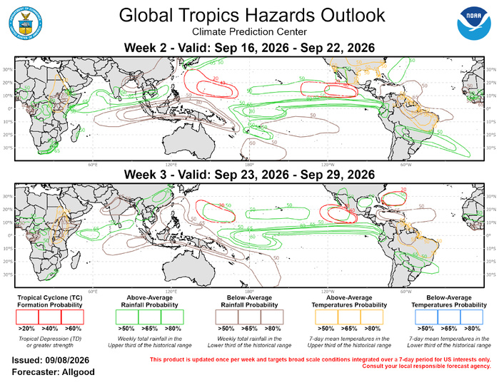
Forecasts for above- and below-normal precipitation were made using historical composites of El Niño events, with any MJO signal not favored to overcome the strong base state. A skill-weighted consolidation of dynamical model guidance reveals precipitation patterns strongly consistent with this stationary low frequency signal, with a high probability for enhanced (suppressed) rainfall across the tropical North Pacific (Maritime Continent). The MJO may contribute to enhanced convection across the North Indian Ocean and parts of Southeast Asia, though a faster than normal retreat of the South Asian Monsoon is favored, which is typical during strong El Niño events. Dynamical model forecasts indicate a potential for prolonged extreme heat across much of Brazil, with elevated temperatures also favored across eastern Africa. Above-normal temperatures (> 50%) are also forecast across the US southern tier during Week-2.
For hazardous weather concerns in your area during the next two weeks, please refer to your local NWS office, the Medium Range Hazards Forecast from the Weather Prediction Center (WPC), and the CPC Week-2 Hazards Outlook. Forecasts made over Africa and made in coordination with the International Desk at CPC.
For hazardous weather concerns in your area during the next two weeks, please refer to your local NWS office, the Medium Range Hazards Forecast from the Weather Prediction Center (WPC), and the CPC Week-2 Hazards Outlook. Forecasts made over Africa and made in coordination with the International Desk at CPC.