

CLICK ON THE IMAGERIES BELOW TO GET THEM ENLARGED

| JTWC PH JTWC FACEBOOK Joint Typhoon Warning Center National Hurricane Center |
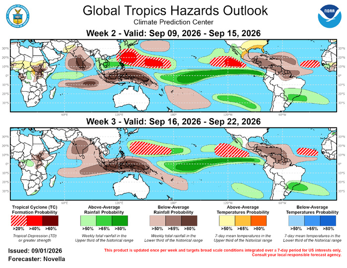
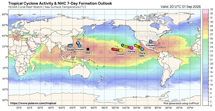
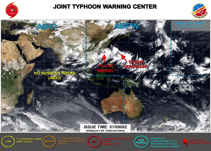
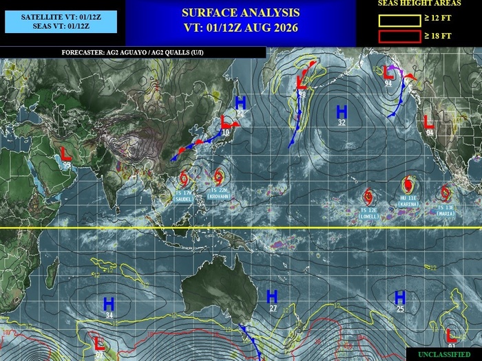
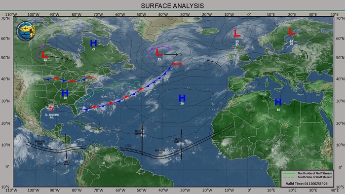
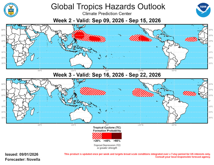
| GTH Outlook Discussion Last Updated - 09/01/26 Valid - 09/09/26 - 09/22/26 The MJO appears to remain active, however its strength and phasing have become increasingly difficult to detect in the MJO based monitoring and forecast tools due to the strong El Nino, which continues to be the overwhelmingly dominant tropical mode of variability this summer. During the past week, RMM observations feature an MJO signal gaining some amplitude but remaining in phase 7 with little to no eastward propagation. Upper-level velocity potential anomaly fields continue to depict a well-defined wave-1 pattern tied to the strong El Nino, though there are subtle indications of subseasonal activity associated with an eastward extension of enhanced divergence aloft over the tropical Atlantic during late August. Embedded MJO activity is also supported by lower-level zonal wind observations focused to the north of the equator, which reveal an extension of anomalous westerlies relaxing the enhanced trade regime over the eastern Pacific, and likely contributed to the formation of multiple Tropical Cyclone (TCs) in the basin during the past week. Looking ahead, the majority of dynamical model RMM forecasts favor a mean MJO signal remaining quasi-stationary over the western Pacific with high ensemble spread. One notable outlier is the ECMWF, which has been the most progressive with the MJO and features more ensemble members falling into the lower half of the phase diagram in recent initializations. Over the past few weeks, the RMM index has struggled to fully propagate the MJO signal out of the western Pacific during August which appears to be directly tied to the strengthening El Nino conditions. Specifically, as the atmospheric coupling and convective responses have grown stronger and more expansive with the warming sea surface temperatures in the Pacific, the 120-day mean removal in RMM that is intended to isolate subseasonal activity may not be sufficient for this major El Nino event. This is supported by a low pass filtered projection of OLR and zonal wind observations onto RMM which shows a signal firmly fixed in phase 7 that has grown to exceed well over 2 standard deviations in amplitude since July. As a result of this inadequacy to fully remove the interannual signal in RMM, the MJO outlook relies more on the objective wavenumber-frequency filtering, as well as forecast variations in the strength of the low frequency dipole established throughout the global tropics, where an embedded, eastward propagating MJO would serve to modulate these background state responses. Based on wave filtered upper-level velocity potential anomaly forecasts from the CFS, GEFS and ECMWF, the MJO is expected to propagate across the Western Hemisphere and return to the Indian Ocean. This would favor increased chances for additional TC development in the eastern Pacific and Atlantic, with lower chances for formation in the western Pacific. However, these odds are still largely tempered by El Nino during the outlook period. During the past week, seven TCs developed in the equatorial Pacific (Bang-lang, Etau, Karina, Lowell, Marie, Krovanh, Saudel), and two TCs in the Atlantic (Dolly, Eduoard), with six that are currently active. In the western Pacific, both TCs Bang-lang and Etau formed on 8/27 and peaked at Category 1 and Tropical Storm intensity, respectively, and have since undergone extratropical transition in the western Pacific. Krovanh formed on 9/1 near 23N/130E in the northern Philippine Sea. The Joint Typhoon Warning Center (JTWC) expects the newly formed system to track northwestward towards the southern islands of Japan, however track uncertainty remains quite high. Following the landfall of TC Saudel over eastern China on 8/28, its remnant circulation drifted into the northern South China Sea and reformed on 9/1. The JTWC expects Saudel to maintain Tropical Storm intensity during the next day or so, while recurving back to the west. Like Krovanh, there remains high uncertainty with the forecast track and intensity of this system. For future updates, please refer to: https://www.metoc.navy.mil/jtwc/jtwc.html . In the central Pacific, TCs Karina and Lowell both formed on 8/27 near 11N/11W and 11N/134W, respectively. Karina underwent rapid intensification a few days ago, and is currently tracking westward as a Major Category 4 system. The National Hurricane Center (NHC) expects Karina to experience fluctuations in intensity associated with eyewall replacement cycles, but gradually weaken as it encounters a drier, and more stable air mass later this week. While there continues to be considerable uncertainty in regards to its eventual track beyond the next 5 days, impacts to Hawaii cannot be ruled out as guidance continues to favor elevated chances for above-normal precipitation over much of the Island chain. To the southeast of Hawaii, Lowell strengthened to a Category 1 system during the past 24 hours, and remains forecast to strengthen into a Major Hurricane and maintain a westward track several hundred miles to the south of the Big Island. While Lowell is expected to be distant enough to avoid any adverse impacts, any northward changes in its track could also bring elevated winds and enhanced precipitation to Hawaii later this week. It is worth noting that dynamical models have not shown much (if any) tendency of a binary interaction between Lowell and Karina, as the systems are expected to remain of sufficient distance from one another. In the eastern Pacific, TC Marie formed on 9/1 near 11N/108W where the NHC expects the system to strengthen to a Category 1 Hurricane and take more of northerly track compared to its TC counterparts Karina and Lowell to the west. Marie’s forecast track actually appears to be influenced by the extratropical transition of the aforementioned TCs Banlang and Etau in the western Pacific. Their absorption into the westerlies is expected to amplify the mid-level pattern across the northern Pacific, and force a deepening trough over the West Coast to help steer Marie northward later this week. While the official NHC track keeps Marie to the west of the Gulf of California, models have been consistent in favoring enhanced moisture advection overspreading the western CONUS, where heavy precipitation is possible by this weekend and into the following week. Across the Atlantic, TC Dolly formed on 8/27 in the Main Development Region (MDR) near 14N/38W and peaked as a Tropical Storm, but quickly succumbed to the El Nino related shear environment entrenched throughout the Caribbean and western MDR. Its remnants continued to track northwestward to bring increased precipitation amounts to parts of Puerto Rico and the Virgin Islands before fully dissipating on 8/31 with zero chances for redevelopment. TC Eduoard formed as a Tropical Depression on 8/31 in the central Gulf of America. Although the NHC expects Eduoard to be short-lived TC, landfall forecast over western Gulf will likely bring Tropical Storm conditions for portions of Texas and Louisiana with heavy rain and flash flooding being the primary threat in the coming days. For further information on these active TCs in the central and eastern Pacific and Atlantic basins, please refer to the National Hurricane Center (NHC) at: https://www.nhc.noaa.gov/ For week-1, there are increased chances for additional TC development in the western Pacific associated with a disturbance in the northern Philippine Sea. In the wake of the week-1 TC activity, much of the northern Philippine Sea is favored to remain broadly cyclonic, where deterministic solutions show additional low development early in week-2. In addition, ensembles and probabilistic TC tools have been consistent in favoring a separate area of mean low development to the east of the Marianas between 150E-165E which has been a consistent location for TC formation associated with the ongoing El Nino. Therefore, a pair of 40% chances are posted for week-2, with a broad, enveloping area of 20% chances from the Philippines to approximately the Date Line. For week-3, the large scale environment is expected to remain favorable for additional development, with extended range tools highlighting the best chances between 140E-170E, prompting 20% chances in the updated outlook. Across the eastern Pacific, additional TC development is favored in the wake of TC Marie. The NHC is currently monitoring an area located near 110W with 20% chances of development (as of 11am PDT) during the next seven days. While the ECMWF has backed off somewhat on formation chances likely due to the gradual return of enhanced trades and higher shear favored to the south of Mexico, Google AI solutions maintain an increased number of deepening lows between 125W-105W early in week-2. While formation may occur during week-1, 40% chances are posted over this portion of the Pacific with a broader area of 20% chances issued extending westward to 140W to capture any delay in formation during the week-2 period. For week-3, 20% chances are also posted over roughly the same area based on elevated signals in the extended range probabilistic guidance with climatological support. Over the tropical Atlantic, models have been consistent in featuring another easterly wave propagating off West Africa later next week. As has been the case before, the most likely area of development is across the eastern MDR (east of 40W) where El Nino shearing is expected to remain the lowest. Given that the week-2 outlook covers the most climatologically active period for the Atlantic, 40% chances were considered, however, probabilistic tools have trended more on the weak side and 20% chances are issued between 40W-20W. By week-3, some of the shearing in the MDR is favored to relax further to the west, increasing the potential for development beyond 40W and a slightly broader area of 20% chances is issued. Outside of the MDR, TC development remains possible across the Gulf of America and in the higher latitudes of the Atlantic later in September where shearing is forecast to be lower. However, no corresponding TC shapes are posted due to a lack of support in the tools, with models also typically exhibiting low skill for these areas. |

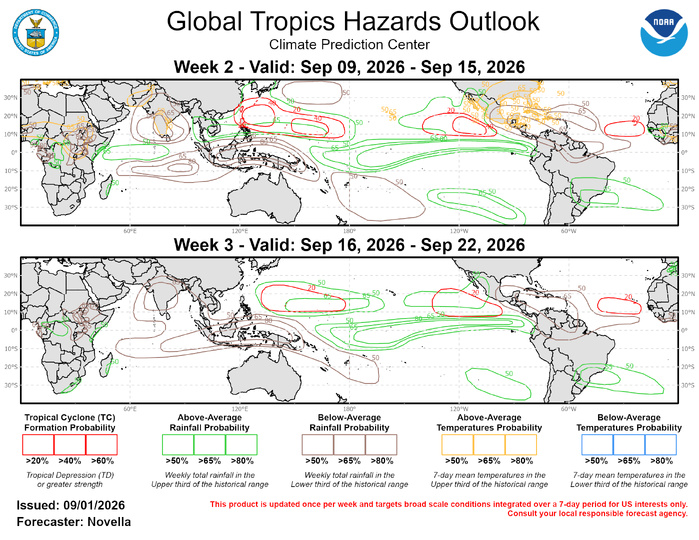
The precipitation outlook for weeks 2 and 3 is largely based on El Nino composites and western Hemispheric MJO events for Aug-Oct, and informed by a consolidated blend of CFSv2, GEFS, and ECMWF ensemble mean solutions. Above-normal temperatures with possible extreme heat conditions favored for portions of the southern CONUS during week-2. Anomalously warm conditions are also forecast for portions of Africa, southern Europe, India, and south-central Asia based on calibrated temperature tools. For hazardous weather concerns in your area during the next two weeks, please refer to your local NWS office, the Medium Range Hazards Forecast from the Weather Prediction Center (WPC), and the CPC Week-2 Hazards Outlook. Forecasts made over Africa and made in coordination with the International Desk at CPC.