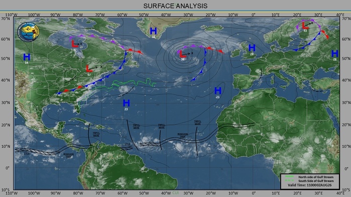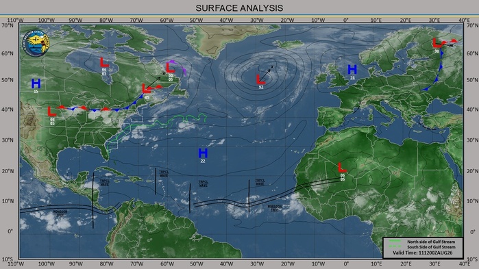


CLICK ON THE IMAGERIES BELOW TO GET THEM ENLARGED

JTWC PH
JTWC FACEBOOK
Joint Typhoon Warning Center
National Hurricane Center
GTH Outlook Discussion
Last Updated - 08/11/26
Valid - 08/19/26 - 09/01/26
The Madden Julian Oscillation (MJO) has continued a pattern of constructive and destructive interference with the El Nino low-frequency base state over the past few months as the El Nino signal has strengthened. Over the past week, the RMM-based index showed the MJO intensifying as it moved through the Maritime Continent and into the Western Pacific (Phase 6) where it once again began to constructively interfere with El Nino. The MJO signal has now reached a stronger amplitude than the last time it emerged in Phase 6, back in late June when the El Nino signal was superimposed on the enhanced phase of the MJO. Upper-level velocity potential anomalies over the past week show a weak MJO signal farther west moving through the Indian Ocean, suggesting that the strong El Nino background state may be distorting the position of the MJO in RMM-space.
With this ongoing constructive interference with the El Nino base state, RMM-based forecasts keep the MJO signal over the Western Pacific (Phase 6) for the next two weeks. Although consistent with phasing, models are split on the amplitude of the signal, with the ECMWF and CFS predicting a robust MJO over the next week and the GEFS maintaining a weaker signal. During Weeks 2 and 3, the GEFS begins to amplify the signal and maintains a strong MJO, while the ECMWF shows a weakening signal moving into the unit circle. By the end of week-3, the models agree on the signal moving into Phase 7. Over the next four weeks, the upper-level velocity potential anomalies show a stationary wave-1 pattern with the enhanced divergence envelope remaining over the Eastern Pacific. However, eastward propagation of the MJO signal can be seen in the wave filtering, showing the signal propagating from the Indian Ocean into the far Eastern Pacific.
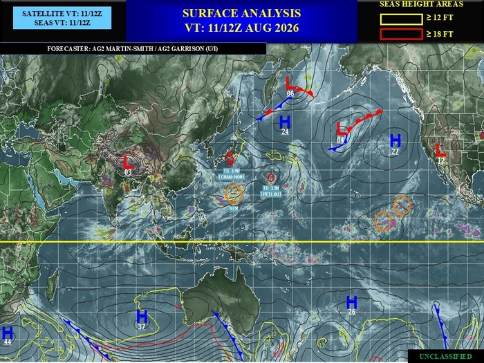
Over the past week, three tropical cyclones (TCs) formed in the Western Pacific Ocean, while TC Dolphin (which formed back on 7/29) continued tracking westward towards the coast of China, finally making landfall in the Zhejiang Province, south of Shanghai, on 8/9. TC Kujira reached tropical storm strength on 8/5 as it turned westward, quickly making landfall along the western coast of the northern Philippines. After dissipating, the system interacted with TC Dolphin and reorganized, being renamed TC Peilou on 8/9. TC Peilou has been moving northeastward in the open ocean and is expected to dissipate shortly. TC Chan-Hom formed on 8/7 at a high latitude of 29N / 161E after starting out as a monsoonal depression. Chan-Hom moved westward and made landfall off the eastern coast of Honshu, Japan, tracking north of Tokyo. The Joint Typhoon Warning Center (JTWC) forecasts the system possibly reemerging over the Sea of Japan but will quickly dissipate under the high shear environment. Finally, 15W formed as a depression on 8/10 in the northern Western Pacific (26N/160E) and quickly dissipated on 8/11.
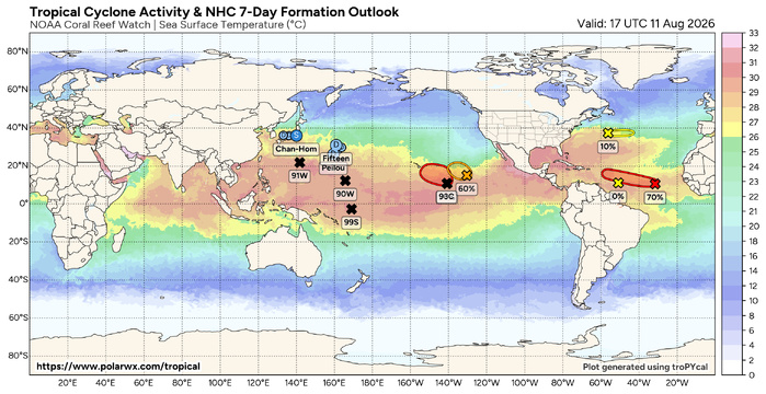
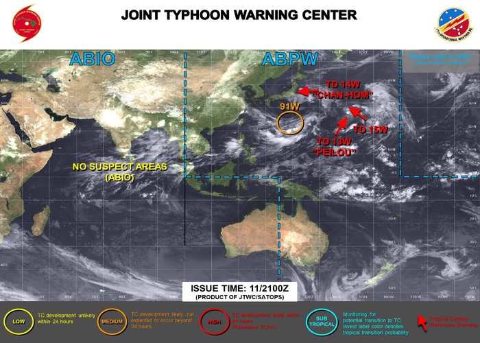
Over the next week, the JTWC is predicting a 70% chance of formation in the Western Pacific (91W) between 138 – 148 deg E, centered near 23N. There is also a disturbance in the South Pacific that is being watched for possible cyclogenesis (99P), but probabilities are low during the Southern Hemisphere off-season. The National Hurricane Center (NHC) is also watching many areas for possible cyclogenesis in both the Eastern Pacific and the Atlantic over the next week. In the Eastern Pacific, NHC has a 90% chance of development (CP93) about 1100 miles southeast of the Hawaiian Islands and interests across Hawaii are advised to closely monitor this system. There is also a 60% chance of development in the open waters from around 140 to 128 deg W. Over the Atlantic, NHC has a 70% chance of development stretching from 30 - 60 deg W in the Main Development Region (MDR) and a 10% chance of development in the open Atlantic above 35N. For further updates on active systems and possible Week-1 development, please refer to the JTWC at https://www.metoc.navy.mil/jtwc/jtwc.html and the NHC at https://www.nhc.noaa.gov/.
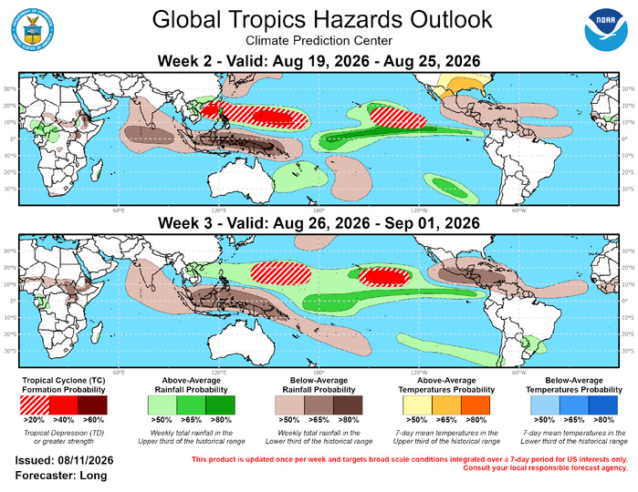
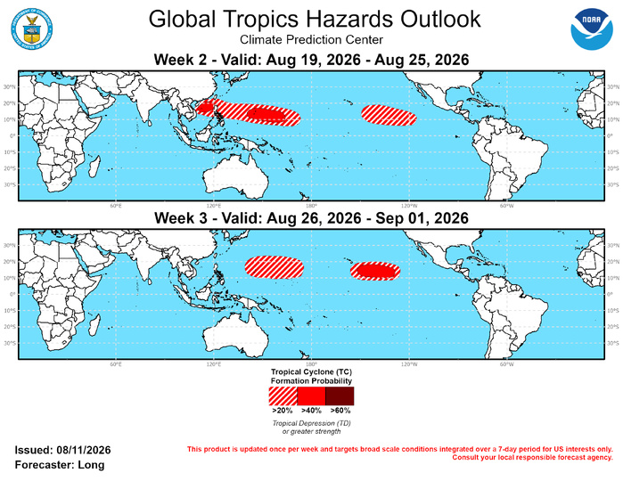
With the MJO and base state constructively interfering to create a strong convective envelope over the central and eastern Pacific, conditions are conducive for TC development over much of the Pacific Ocean during both Weeks 2 and 3. During Week-2, one broad area is highlighted with 20-40% chances of TC formation in the Western Pacific from about 108 to 173 deg E, with a focus on two areas containing 40-60% probabilities. These higher probabilities are posted over the South China Sea and farther east from 140 to 164 deg E. During Week-3, a 20-40% chance of formation is posted from about 140 to 175 deg E based on MJO TC composites for phases 6-7 and dynamical model support.
In the Eastern Pacific, strong wind shear is forecasted to remain over much of the region throughout the forecast period. Although models support TC formation along the Mexican coastline, it is difficult to expect anything to overcome this high shear environment. Formation is more likely farther west towards the Central Pacific where wind shear is forecasted to be weaker, resulting in a 20-40% chance of development from 150 to 115 deg W. During Week-3, a similar region shifted slightly westward is highlighted for 40-60% chances, located southeast of Hawaii. Model support increases for TC formation in the region during Week-3 and both weeks have support from MJO TC composites.
In the Atlantic, there is the possibility for a few potential disturbances off the African coast during weeks 2 and 3, but the high shear environment in the Main Development Region looks to inhibit any continued development as they move westward. Therefore, probabilities of formation remain below 20% and no corresponding TC areas are posted.
JTWC FACEBOOK
Joint Typhoon Warning Center
National Hurricane Center
GTH Outlook Discussion
Last Updated - 08/11/26
Valid - 08/19/26 - 09/01/26
The Madden Julian Oscillation (MJO) has continued a pattern of constructive and destructive interference with the El Nino low-frequency base state over the past few months as the El Nino signal has strengthened. Over the past week, the RMM-based index showed the MJO intensifying as it moved through the Maritime Continent and into the Western Pacific (Phase 6) where it once again began to constructively interfere with El Nino. The MJO signal has now reached a stronger amplitude than the last time it emerged in Phase 6, back in late June when the El Nino signal was superimposed on the enhanced phase of the MJO. Upper-level velocity potential anomalies over the past week show a weak MJO signal farther west moving through the Indian Ocean, suggesting that the strong El Nino background state may be distorting the position of the MJO in RMM-space.
With this ongoing constructive interference with the El Nino base state, RMM-based forecasts keep the MJO signal over the Western Pacific (Phase 6) for the next two weeks. Although consistent with phasing, models are split on the amplitude of the signal, with the ECMWF and CFS predicting a robust MJO over the next week and the GEFS maintaining a weaker signal. During Weeks 2 and 3, the GEFS begins to amplify the signal and maintains a strong MJO, while the ECMWF shows a weakening signal moving into the unit circle. By the end of week-3, the models agree on the signal moving into Phase 7. Over the next four weeks, the upper-level velocity potential anomalies show a stationary wave-1 pattern with the enhanced divergence envelope remaining over the Eastern Pacific. However, eastward propagation of the MJO signal can be seen in the wave filtering, showing the signal propagating from the Indian Ocean into the far Eastern Pacific.
Over the past week, three tropical cyclones (TCs) formed in the Western Pacific Ocean, while TC Dolphin (which formed back on 7/29) continued tracking westward towards the coast of China, finally making landfall in the Zhejiang Province, south of Shanghai, on 8/9. TC Kujira reached tropical storm strength on 8/5 as it turned westward, quickly making landfall along the western coast of the northern Philippines. After dissipating, the system interacted with TC Dolphin and reorganized, being renamed TC Peilou on 8/9. TC Peilou has been moving northeastward in the open ocean and is expected to dissipate shortly. TC Chan-Hom formed on 8/7 at a high latitude of 29N / 161E after starting out as a monsoonal depression. Chan-Hom moved westward and made landfall off the eastern coast of Honshu, Japan, tracking north of Tokyo. The Joint Typhoon Warning Center (JTWC) forecasts the system possibly reemerging over the Sea of Japan but will quickly dissipate under the high shear environment. Finally, 15W formed as a depression on 8/10 in the northern Western Pacific (26N/160E) and quickly dissipated on 8/11.
Over the next week, the JTWC is predicting a 70% chance of formation in the Western Pacific (91W) between 138 – 148 deg E, centered near 23N. There is also a disturbance in the South Pacific that is being watched for possible cyclogenesis (99P), but probabilities are low during the Southern Hemisphere off-season. The National Hurricane Center (NHC) is also watching many areas for possible cyclogenesis in both the Eastern Pacific and the Atlantic over the next week. In the Eastern Pacific, NHC has a 90% chance of development (CP93) about 1100 miles southeast of the Hawaiian Islands and interests across Hawaii are advised to closely monitor this system. There is also a 60% chance of development in the open waters from around 140 to 128 deg W. Over the Atlantic, NHC has a 70% chance of development stretching from 30 - 60 deg W in the Main Development Region (MDR) and a 10% chance of development in the open Atlantic above 35N. For further updates on active systems and possible Week-1 development, please refer to the JTWC at https://www.metoc.navy.mil/jtwc/jtwc.html and the NHC at https://www.nhc.noaa.gov/.
With the MJO and base state constructively interfering to create a strong convective envelope over the central and eastern Pacific, conditions are conducive for TC development over much of the Pacific Ocean during both Weeks 2 and 3. During Week-2, one broad area is highlighted with 20-40% chances of TC formation in the Western Pacific from about 108 to 173 deg E, with a focus on two areas containing 40-60% probabilities. These higher probabilities are posted over the South China Sea and farther east from 140 to 164 deg E. During Week-3, a 20-40% chance of formation is posted from about 140 to 175 deg E based on MJO TC composites for phases 6-7 and dynamical model support.
In the Eastern Pacific, strong wind shear is forecasted to remain over much of the region throughout the forecast period. Although models support TC formation along the Mexican coastline, it is difficult to expect anything to overcome this high shear environment. Formation is more likely farther west towards the Central Pacific where wind shear is forecasted to be weaker, resulting in a 20-40% chance of development from 150 to 115 deg W. During Week-3, a similar region shifted slightly westward is highlighted for 40-60% chances, located southeast of Hawaii. Model support increases for TC formation in the region during Week-3 and both weeks have support from MJO TC composites.
In the Atlantic, there is the possibility for a few potential disturbances off the African coast during weeks 2 and 3, but the high shear environment in the Main Development Region looks to inhibit any continued development as they move westward. Therefore, probabilities of formation remain below 20% and no corresponding TC areas are posted.

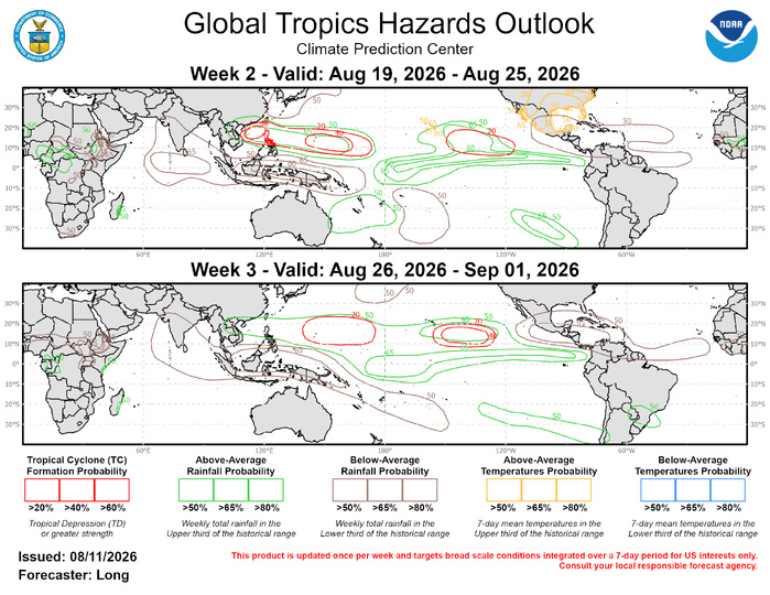
The precipitation outlook for Weeks 2 and 3 is based on the skill weighted consolidated blend of GEFS, CFS, and ECMWF ensemble forecast systems, historical composites during Jul-Sep for MJO phases 6-7, and the low frequency influence associated with El Nino. Below-average rainfall is expected to continue over the Indian Ocean, the Maritime Continent, and the Caribbean Sea. Above-normal rainfall is expected across the equatorial Pacific and the North Western Pacific in association with possible TC activity and the combined MJO-El Nino influence. Increased chances for above-normal temperatures are expected from the Central Plains to the Southeast United States during Week-2 and may result in prolonged periods of extreme heat in some areas. Increased chances for above-normal temperatures are also expected for all of Hawaii Islands. For hazardous weather conditions in your area during the next two weeks, please refer to your local NWS office, the Medium Range Hazards Forecast from the Weather Prediction Center (WPC), and the CPC Week-2 Hazards Outlook. Forecasts issued over Africa are made in coordination with the International Desk at CPC.